![](/images/other/stat-length.png)
![Randonnée A pied Dinant - Thynes-Taviet - Photo](https://media.geolcdn.com/t/1900/400/ext.pjpeg?maxdim=2&url=https%3A%2F%2Fstatic1.geolcdn.com%2Fsiteimages%2Fupload%2Ffiles%2F1545311037marcheuse_200dpi.jpg)
Thynes-Taviet
ValleedelaMeuse
Utilisateur
![Longueur](/images/other/stat-length.png)
Longueur
9,8 km
![Altitude max](https://static1.geolcdn.com/siteimages/upload/files/1508320355ic_sort_altitude_max_24dp.png)
Altitude max
302 m
![Dénivelé positif](https://static1.geolcdn.com/siteimages/upload/files/1508320355ic_sort_den_pos_24dp.png)
Dénivelé positif
216 m
![Km-Effort](/images/other/stat-length.png)
Km-Effort
12,7 km
![Altitude min](https://static1.geolcdn.com/siteimages/upload/files/1508320355ic_sort_altitude_min_24dp.png)
Altitude min
188 m
![Dénivelé négatif](https://static1.geolcdn.com/siteimages/upload/files/1508320355ic_sort_den_neg_24dp.png)
Dénivelé négatif
211 m
![Boucle](https://static1.geolcdn.com/siteimages/upload/files/16400158638029165_repeat_loop_refresh_sync_direction_icon.png)
Boucle
Oui
Date de création :
2019-10-04 11:55:14.248
Dernière modification :
2019-10-04 12:02:23.55
![A pied](https://static1.geolcdn.com/sitytour/trail-icons/100.png)
3h20
Difficulté : Facile
![Scannez ce code QR pour ouvrir la randonnée dans l'application SityTrail](https://capi.geolives.com/qq0zvz2zws4bq2lad0pu/sitytour/trails/2221573/qr.png?size=200)
Application GPS de randonnée GRATUITE
À propos
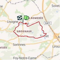
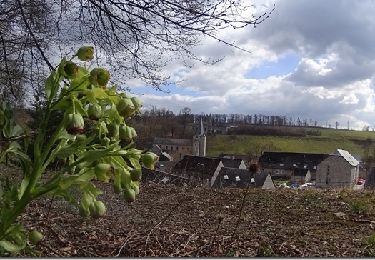
Randonnée A pied de 9,8 km à découvrir à Wallonie, Namur, Dinant. Cette randonnée est proposée par ValleedelaMeuse.
Description
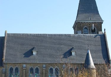
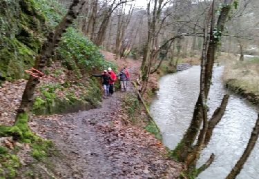
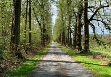
La balade commence devant l'église de Thynes .Sortir du village et rejoindre le GR 575.Au village de Taviet , retour sur Thynes par le bois Saint Jacques et le polissoir.
Localisation
Pays :
Belgique
Région :
Wallonie
Département/Province :
Namur
Commune :
Dinant
Localité :
Thynes
Départ:(Dec)
Départ:(UTM)
641560 ; 5571630 (31U) N.
Commentaires
Randonnées à proximité
![Randonnée Marche Yvoir - Balade à Spontin - Photo](https://media.geolcdn.com/t/375/260/ext.jpg?maxdim=2&url=https%3A%2F%2Fservices.sitytrail.com%2FGeolivesWS%2FDownloadMedia.ashx%3FTrailID%3D437057%26Media%3D4788e304-dd7c-47cc-a067-745c9f490e74.JPG)
![Marche Marche](https://static1.geolcdn.com/sitytour/trail-icons/101.png)
Balade à Spontin
Marche
Très facile
(4)
Yvoir,
Wallonie,
Namur,
Belgique
![](/images/other/stat-length.png)
5 km | 6,2 km-effort
1h 20min
![](https://static1.geolcdn.com/siteimages/upload/files/16400158638029165_repeat_loop_refresh_sync_direction_icon.png)
Oui
![Randonnée Marche Ciney - CINEY- Sovet- Promenade de la Chapelle de Jet - Photo](https://media.geolcdn.com/t/375/260/ext.jpg?maxdim=2&url=https%3A%2F%2Fservices.sitytrail.com%2FGeolivesWS%2FDownloadMedia.ashx%3FTrailID%3D250703%26Media%3Da960eafd-7fe9-4ce6-854f-8ccad456b86e.JPG)
![Marche Marche](https://static1.geolcdn.com/sitytour/trail-icons/101.png)
CINEY- Sovet- Promenade de la Chapelle de Jet
Marche
Très facile
(2)
Ciney,
Wallonie,
Namur,
Belgique
![](/images/other/stat-length.png)
7,2 km | 8,9 km-effort
1h 52min
![](https://static1.geolcdn.com/siteimages/upload/files/16400158638029165_repeat_loop_refresh_sync_direction_icon.png)
Oui
![Randonnée Marche Dinant - Dinant: autour de la Citadelle. - Photo](https://media.geolcdn.com/t/375/260/0debd692-1141-41b3-8018-db8fdb788a39.jpg&format=jpg&maxdim=2)
![Marche Marche](https://static1.geolcdn.com/sitytour/trail-icons/101.png)
Dinant: autour de la Citadelle.
Marche
Facile
(4)
Dinant,
Wallonie,
Namur,
Belgique
![](/images/other/stat-length.png)
5,7 km | 7,5 km-effort
1h 40min
![](https://static1.geolcdn.com/siteimages/upload/files/16400158638029165_repeat_loop_refresh_sync_direction_icon.png)
Oui
![Randonnée Marche Yvoir - PURNODE (Dessous-Ham) - Photo](https://media.geolcdn.com/t/375/260/ext.jpg?maxdim=2&url=https%3A%2F%2Fservices.sitytrail.com%2FGeolivesWS%2FDownloadMedia.ashx%3FTrailID%3D512858%26Media%3Dfix__20160114135435.jpg)
![Marche Marche](https://static1.geolcdn.com/sitytour/trail-icons/101.png)
PURNODE (Dessous-Ham)
Marche
Facile
(2)
Yvoir,
Wallonie,
Namur,
Belgique
![](/images/other/stat-length.png)
11,6 km | 14,9 km-effort
3h 21min
![](https://static1.geolcdn.com/siteimages/upload/files/16400158638029165_repeat_loop_refresh_sync_direction_icon.png)
Oui
![Randonnée Marche Ciney - Achene nouvelle balade - Photo](https://media.geolcdn.com/t/375/260/e6788412-cece-4747-ade2-b3343aad0d3b.jpg&format=jpg&maxdim=2)
![Marche Marche](https://static1.geolcdn.com/sitytour/trail-icons/101.png)
Achene nouvelle balade
Marche
Très difficile
(2)
Ciney,
Wallonie,
Namur,
Belgique
![](/images/other/stat-length.png)
16,4 km | 19,7 km-effort
3h 27min
![](https://static1.geolcdn.com/siteimages/upload/files/16400158638029165_repeat_loop_refresh_sync_direction_icon.png)
Oui
![Randonnée Marche Dinant - Foy notre dame - Photo](https://media.geolcdn.com/t/375/260/ext.jpg?maxdim=2&url=https%3A%2F%2Fservices.sitytrail.com%2FGeolivesWS%2FDownloadMedia.ashx%3FTrailID%3D559258%26Media%3D80207791-a904-47ff-b52d-c8dad350e753.jpg)
![Marche Marche](https://static1.geolcdn.com/sitytour/trail-icons/101.png)
Foy notre dame
Marche
Moyen
(2)
Dinant,
Wallonie,
Namur,
Belgique
![](/images/other/stat-length.png)
12,9 km | 17 km-effort
3h 36min
![](https://static1.geolcdn.com/siteimages/upload/files/16400158638029165_repeat_loop_refresh_sync_direction_icon.png)
Oui
![Randonnée Marche Yvoir - RF-Na-07-Spontin_Grande-boucle - Photo](https://media.geolcdn.com/t/375/260/ext.jpg?maxdim=2&url=https%3A%2F%2Fservices.sitytrail.com%2FGeolivesWS%2FDownloadMedia.ashx%3FTrailID%3D545760%26Media%3Dbedb3372-410c-457f-8651-d41c3c453cb6.JPG)
![Marche Marche](https://static1.geolcdn.com/sitytour/trail-icons/101.png)
RF-Na-07-Spontin_Grande-boucle
Marche
Moyen
(5)
Yvoir,
Wallonie,
Namur,
Belgique
![](/images/other/stat-length.png)
9,9 km | 12 km-effort
2h 36min
![](https://static1.geolcdn.com/siteimages/upload/files/16400158638029165_repeat_loop_refresh_sync_direction_icon.png)
Oui
![Randonnée Marche Ciney - CINEY- Sovet- Croix- Promenade de Croix - Photo](https://media.geolcdn.com/t/375/260/ext.jpg?maxdim=2&url=https%3A%2F%2Fservices.sitytrail.com%2FGeolivesWS%2FDownloadMedia.ashx%3FTrailID%3D250704%26Media%3Da960eafd-7fe9-4ce6-854f-8ccad456b86e.JPG)
![Marche Marche](https://static1.geolcdn.com/sitytour/trail-icons/101.png)
CINEY- Sovet- Croix- Promenade de Croix
Marche
Très facile
(2)
Ciney,
Wallonie,
Namur,
Belgique
![](/images/other/stat-length.png)
4,2 km | 5,2 km-effort
1h 5min
![](https://static1.geolcdn.com/siteimages/upload/files/16400158638029165_repeat_loop_refresh_sync_direction_icon.png)
Oui
![Randonnée Marche Dinant - De Thynes vers Taviet - Photo](https://media.geolcdn.com/t/375/260/ext.jpg?maxdim=2&url=https%3A%2F%2Fstatic1.geolcdn.com%2Fsiteimages%2Fupload%2Ffiles%2F1553511878bg_sport_marche.png)
![Marche Marche](https://static1.geolcdn.com/sitytour/trail-icons/101.png)
De Thynes vers Taviet
Marche
Facile
(4)
Dinant,
Wallonie,
Namur,
Belgique
![](/images/other/stat-length.png)
9,5 km | 12,5 km-effort
2h 30min
![](https://static1.geolcdn.com/siteimages/upload/files/16400158638029165_repeat_loop_refresh_sync_direction_icon.png)
Oui