Randonnée Marche Sainte-Foy-de-Peyrolières - la salvetat ste fot fait - Photo
 pidjam
pidjam

Utilisateur

© OpenStreetMap contributors
Longueur
Longueur
10,2 km
Altitude max
Altitude max
322 m
Dénivelé positif
Dénivelé positif
225 m
Km-Effort
Km-Effort  
13,1 km
Altitude min
Altitude min
244 m
Dénivelé négatif
Dénivelé négatif
220 m
Boucle
Boucle
Oui
Date de création :
2019-10-03 12:26:47.744
Dernière modification :
2019-10-03 15:00:33.166

(1 Avis)

Marche
Marche
2h32
Difficulté : Facile

Scannez ce code QR pour ouvrir la randonnée dans l'application SityTrail

Application GPS de randonnée GRATUITE

Logo SityTrail SityTrail

IGN / Instituts géographiques

Télécharger SityTrail sur l'App Store Télécharger SityTrail sur Google Play

Logo SityTrail SityTrail World

Le monde est à vous

Télécharger SityTrail sur l'App Store Télécharger SityTrail sur Google Play Télécharger SityTrail sur Huawei AppGallery

À propos

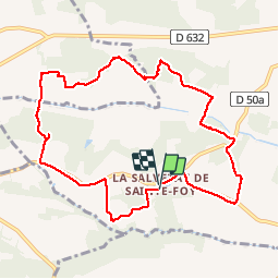
Randonnée Marche de 10,2 km à découvrir à Occitanie, Haute-Garonne, Sainte-Foy-de-Peyrolières. Cette randonnée est proposée par pidjam.

Profil altimétrique

Localisation

Pays :
France
Région :
Occitanie
Département/Province :
Haute-Garonne
Commune :
Sainte-Foy-de-Peyrolières
Localité :
Unknown
Départ:(UTM)
346558 ; 4814935 (31T) N.

Commentaires

Veuillez vous connecter pour laisser un commentaire ou une note


Belle balade conforme au descriptif


Randonnées à proximité

Randonnée Marche Sainte-Foy-de-Peyrolières - RANDO-Ste Foy Téléthon 2012 - Photo
Marche
Polo-31

Marche

Facile
Sainte-Foy-de-Peyrolières, Occitanie, Haute-Garonne, France
8 km | 9,3 km-effort
2h 2min
Oui
Randonnée Marche Sainte-Foy-de-Peyrolières - Lac et bois autour de Sainte Foy de Peyrolières - Photo
Marche
tracegps

Marche

Facile
Sainte-Foy-de-Peyrolières, Occitanie, Haute-Garonne, France
9 km | 11,2 km-effort
2h 30min
Oui
Randonnée Marche Sainte-Foy-de-Peyrolières - Ste Foy de Peyrolières 13 Avril 2020 - Photo
Marche
daniel3157

Marche

Facile
Sainte-Foy-de-Peyrolières, Occitanie, Haute-Garonne, France
16,4 km | 21 km-effort
4h 58min
Oui
Randonnée Marche Forgues - Forgues - Photo
Marche
pidjam

Marche

Facile
Forgues, Occitanie, Haute-Garonne, France
9,3 km | 12 km-effort
2h 34min
Oui
Randonnée Marche Sainte-Foy-de-Peyrolières - Randonnée Sainte Foy de Peyrolières  - Photo
Marche
Fafou64

Marche

Sainte-Foy-de-Peyrolières, Occitanie, Haute-Garonne, France
10,7 km | 12,9 km-effort
2h 39min
Oui
Randonnée Marche Rieumes - lahage - Photo
Marche
colducaillou

Marche

Très facile
Rieumes, Occitanie, Haute-Garonne, France
8,6 km | 10,9 km-effort
2h 25min
Oui
Randonnée Marche Saint-Thomas - st thomas long - Photo
Marche
pidjam

Marche

Facile
Saint-Thomas, Occitanie, Haute-Garonne, France
12,1 km | 15,8 km-effort
3h 22min
Oui
Randonnée Vélo Sainte-Foy-de-Peyrolières - V003-Tour LASSERRE - Photo
Vélo
Polo-31

Vélo

Difficile
Sainte-Foy-de-Peyrolières, Occitanie, Haute-Garonne, France
141 km | 163 km-effort
6h 0min
Oui
Randonnée Vélo Sainte-Foy-de-Peyrolières - V002-Ste Foy Col de la Core - Photo
Vélo
Polo-31

Vélo

Difficile
Sainte-Foy-de-Peyrolières, Occitanie, Haute-Garonne, France
223 km | 260 km-effort
14h 46min
Oui


Fermer
Mes abonnements