![](/images/other/stat-length.png)
![Randonnée Marche Arlon - Udange - Meix-le-Tige - Photo](https://media.geolcdn.com/t/1900/400/ext.pjpeg?maxdim=2&url=https%3A%2F%2Fstatic1.geolcdn.com%2Fsiteimages%2Fupload%2Ffiles%2F1553511878bg_sport_marche.png)
Udange - Meix-le-Tige
papa-sanglier
Utilisateur
![Longueur](/images/other/stat-length.png)
Longueur
12,6 km
![Altitude max](https://static1.geolcdn.com/siteimages/upload/files/1508320355ic_sort_altitude_max_24dp.png)
Altitude max
399 m
![Dénivelé positif](https://static1.geolcdn.com/siteimages/upload/files/1508320355ic_sort_den_pos_24dp.png)
Dénivelé positif
163 m
![Km-Effort](/images/other/stat-length.png)
Km-Effort
14,7 km
![Altitude min](https://static1.geolcdn.com/siteimages/upload/files/1508320355ic_sort_altitude_min_24dp.png)
Altitude min
310 m
![Dénivelé négatif](https://static1.geolcdn.com/siteimages/upload/files/1508320355ic_sort_den_neg_24dp.png)
Dénivelé négatif
165 m
![Boucle](https://static1.geolcdn.com/siteimages/upload/files/16400158638029165_repeat_loop_refresh_sync_direction_icon.png)
Boucle
Oui
Date de création :
2014-12-10 00:00:00.0
Dernière modification :
2014-12-10 00:00:00.0
![Marche](https://static1.geolcdn.com/sitytour/trail-icons/101.png)
2h09
Difficulté : Facile
![Scannez ce code QR pour ouvrir la randonnée dans l'application SityTrail](https://capi.geolives.com/qq0zvz2zws4bq2lad0pu/sitytour/trails/221771/qr.png?size=200)
Application GPS de randonnée GRATUITE
À propos
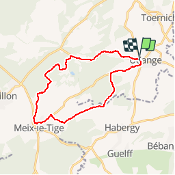
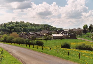
Randonnée Marche de 12,6 km à découvrir à Wallonie, Luxembourg, Arlon. Cette randonnée est proposée par papa-sanglier.
Description
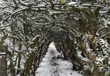
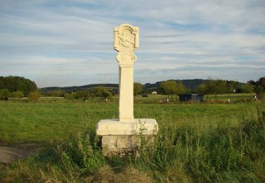
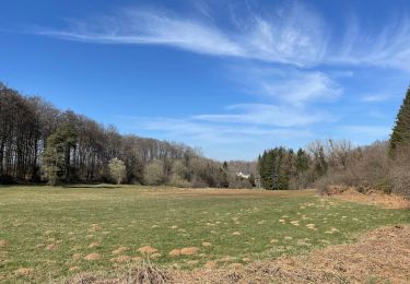
Promenade facile, empruntant des routes très peu fréquentées ou des chemins à travers bois. Nous croisons de nombreux arbres remarquables. Vue magnifique sur Habergy.
Localisation
Pays :
Belgique
Région :
Wallonie
Département/Province :
Luxembourg
Commune :
Arlon
Localité :
Toernich
Départ:(Dec)
Départ:(UTM)
699949 ; 5501994 (31U) N.
Commentaires
Randonnées à proximité
![Randonnée Marche Arlon - 31.265 Arlon - Vieille Ville - Photo](https://media.geolcdn.com/t/375/260/6e3c8fe1-1a08-4d78-ab40-dbec45946f7d.jpg&format=jpg&maxdim=2)
![Marche Marche](https://static1.geolcdn.com/sitytour/trail-icons/101.png)
31.265 Arlon - Vieille Ville
Marche
Facile
(1)
Arlon,
Wallonie,
Luxembourg,
Belgique
![](/images/other/stat-length.png)
4,6 km | 5,3 km-effort
1h 34min
![](https://static1.geolcdn.com/siteimages/upload/files/16400158638029165_repeat_loop_refresh_sync_direction_icon.png)
Oui
![Randonnée A pied Arlon - N° 2 - De Sesselich à Wolkrange - Photo](https://media.geolcdn.com/t/375/260/76977e4f-2882-4817-b7e6-b3bc029201a9.jpeg&format=jpg&maxdim=2)
![A pied A pied](https://static1.geolcdn.com/sitytour/trail-icons/100.png)
N° 2 - De Sesselich à Wolkrange
A pied
Facile
Arlon,
Wallonie,
Luxembourg,
Belgique
![](/images/other/stat-length.png)
7,6 km | 9,5 km-effort
2h 9min
![](https://static1.geolcdn.com/siteimages/upload/files/16400158638029165_repeat_loop_refresh_sync_direction_icon.png)
Oui
![Randonnée A pied Arlon - N° 5 - Udange - Au cœur de la forêt primitive - Photo](https://media.geolcdn.com/t/375/260/256ffff4-9371-48c3-8e4d-7f2e673b9ec6.jpeg&format=jpg&maxdim=2)
![A pied A pied](https://static1.geolcdn.com/sitytour/trail-icons/100.png)
N° 5 - Udange - Au cœur de la forêt primitive
A pied
Facile
Arlon,
Wallonie,
Luxembourg,
Belgique
![](/images/other/stat-length.png)
7 km | 8,6 km-effort
1h 57min
![](https://static1.geolcdn.com/siteimages/upload/files/16400158638029165_repeat_loop_refresh_sync_direction_icon.png)
Oui
![Randonnée A pied Messancy - Promenade de Bébange - Photo](https://media.geolcdn.com/t/375/260/ext.jpg?maxdim=2&url=https%3A%2F%2Fpivotmedia.tourismewallonie.be%2FOTH-A0-0061-225L%2FOTH-A0-0061-225L.jpg)
![A pied A pied](https://static1.geolcdn.com/sitytour/trail-icons/100.png)
Promenade de Bébange
A pied
Facile
(1)
Messancy,
Wallonie,
Luxembourg,
Belgique
![](/images/other/stat-length.png)
6 km | 7,5 km-effort
1h 41min
![](https://static1.geolcdn.com/siteimages/upload/files/16400158638029165_repeat_loop_refresh_sync_direction_icon.png)
Oui
![Randonnée A pied Messancy - Promenade d'Habergy - Photo](https://media.geolcdn.com/t/375/260/ext.jpg?maxdim=2&url=https%3A%2F%2Fpivotmedia.tourismewallonie.be%2FOTH-A0-0062-14VV%2FOTH-A0-0062-14VV.jpg)
![A pied A pied](https://static1.geolcdn.com/sitytour/trail-icons/100.png)
Promenade d'Habergy
A pied
Facile
Messancy,
Wallonie,
Luxembourg,
Belgique
![](/images/other/stat-length.png)
6,7 km | 8,4 km-effort
1h 54min
![](https://static1.geolcdn.com/siteimages/upload/files/16400158638029165_repeat_loop_refresh_sync_direction_icon.png)
Oui
![Randonnée A pied Arlon - La forêt primitive à Udange - Photo](https://media.geolcdn.com/t/375/260/ext.jpg?maxdim=2&url=https%3A%2F%2Fpivotmedia.tourismewallonie.be%2FOTH-A0-0067-0RST%2FOTH-A0-0067-0RST.jpg)
![A pied A pied](https://static1.geolcdn.com/sitytour/trail-icons/100.png)
La forêt primitive à Udange
A pied
Facile
Arlon,
Wallonie,
Luxembourg,
Belgique
![](/images/other/stat-length.png)
6,9 km | 8,5 km-effort
1h 56min
![](https://static1.geolcdn.com/siteimages/upload/files/16400158638029165_repeat_loop_refresh_sync_direction_icon.png)
Oui
![Randonnée A pied Arlon - De Sesselich et Wolkrange accessible à tous - Photo](https://media.geolcdn.com/t/375/260/ext.jpg?maxdim=2&url=https%3A%2F%2Fpivotmedia.tourismewallonie.be%2FOTH-A0-0067-0QTR%2FOTH-A0-0067-0QTR.jpg)
![A pied A pied](https://static1.geolcdn.com/sitytour/trail-icons/100.png)
De Sesselich et Wolkrange accessible à tous
A pied
Facile
Arlon,
Wallonie,
Luxembourg,
Belgique
![](/images/other/stat-length.png)
7,6 km | 9,5 km-effort
2h 9min
![](https://static1.geolcdn.com/siteimages/upload/files/16400158638029165_repeat_loop_refresh_sync_direction_icon.png)
Oui
![Randonnée A pied Arlon - Le Mont Hirtzenberg, prenez de la hauteur - Photo](https://media.geolcdn.com/t/375/260/ext.jpg?maxdim=2&url=https%3A%2F%2Fpivotmedia.tourismewallonie.be%2FOTH-A0-0067-0Q7S%2FOTH-A0-0067-0Q7S.jpg)
![A pied A pied](https://static1.geolcdn.com/sitytour/trail-icons/100.png)
Le Mont Hirtzenberg, prenez de la hauteur
A pied
Facile
Arlon,
Wallonie,
Luxembourg,
Belgique
![](/images/other/stat-length.png)
3,8 km | 5,1 km-effort
1h 8min
![](https://static1.geolcdn.com/siteimages/upload/files/16400158638029165_repeat_loop_refresh_sync_direction_icon.png)
Oui
![Randonnée A pied Arlon - Waltzing-Eischen, balade belgo-luxembourgeoise - Photo](https://media.geolcdn.com/t/375/260/ext.jpg?maxdim=2&url=https%3A%2F%2Fpivotmedia.tourismewallonie.be%2FOTH-A0-0067-0Q4E%2FOTH-A0-0067-0Q4E.jpg)
![A pied A pied](https://static1.geolcdn.com/sitytour/trail-icons/100.png)
Waltzing-Eischen, balade belgo-luxembourgeoise
A pied
Facile
(1)
Arlon,
Wallonie,
Luxembourg,
Belgique
![](/images/other/stat-length.png)
10,3 km | 13 km-effort
2h 57min
![](https://static1.geolcdn.com/siteimages/upload/files/16400158638029165_repeat_loop_refresh_sync_direction_icon.png)
Oui