![](/images/other/stat-length.png)
![Randonnée A pied Draveil - forêt de Sénart entre Draveil et Champrosay - Photo](https://media.geolcdn.com/t/1900/400/ext.pjpeg?maxdim=2&url=https%3A%2F%2Fstatic1.geolcdn.com%2Fsiteimages%2Fupload%2Ffiles%2F1545311037marcheuse_200dpi.jpg)
forêt de Sénart entre Draveil et Champrosay
Surot
Utilisateur
![Longueur](/images/other/stat-length.png)
Longueur
6,1 km
![Altitude max](https://static1.geolcdn.com/siteimages/upload/files/1508320355ic_sort_altitude_max_24dp.png)
Altitude max
95 m
![Dénivelé positif](https://static1.geolcdn.com/siteimages/upload/files/1508320355ic_sort_den_pos_24dp.png)
Dénivelé positif
56 m
![Km-Effort](/images/other/stat-length.png)
Km-Effort
6,8 km
![Altitude min](https://static1.geolcdn.com/siteimages/upload/files/1508320355ic_sort_altitude_min_24dp.png)
Altitude min
59 m
![Dénivelé négatif](https://static1.geolcdn.com/siteimages/upload/files/1508320355ic_sort_den_neg_24dp.png)
Dénivelé négatif
57 m
![Boucle](https://static1.geolcdn.com/siteimages/upload/files/16400158638029165_repeat_loop_refresh_sync_direction_icon.png)
Boucle
Oui
Date de création :
2019-09-25 16:13:12.542
Dernière modification :
2019-09-25 16:17:03.372
![A pied](https://static1.geolcdn.com/sitytour/trail-icons/100.png)
2h10
Difficulté : Facile
![Scannez ce code QR pour ouvrir la randonnée dans l'application SityTrail](https://capi.geolives.com/qq0zvz2zws4bq2lad0pu/sitytour/trails/2213892/qr.png?size=200)
Application GPS de randonnée GRATUITE
À propos
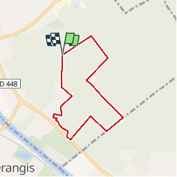
Randonnée A pied de 6,1 km à découvrir à Île-de-France, Essonne, Draveil. Cette randonnée est proposée par Surot.
Description
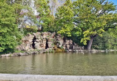
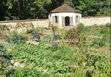
Boucle facile de6 km en forêt de Sénart pour rando douce, passant par le château de Champrosay où est cultivé en saison favorable un joli potager partagé. Pas de dénivelé ou très peu
Localisation
Pays :
France
Région :
Île-de-France
Département/Province :
Essonne
Commune :
Draveil
Localité :
Unknown
Départ:(Dec)
Départ:(UTM)
458023 ; 5391187 (31U) N.
Commentaires
Randonnées à proximité
![Randonnée Marche Juvisy-sur-Orge - GRP CV-IDF 16R Juvisy-sur-Orge à Ballainvilliers - Photo](https://media.geolcdn.com/t/375/260/fc32371e-a9db-4ebb-87ec-b0b2ec43c0ff.jpg&format=jpg&maxdim=2)
![Marche Marche](https://static1.geolcdn.com/sitytour/trail-icons/101.png)
GRP CV-IDF 16R Juvisy-sur-Orge à Ballainvilliers
Marche
Difficile
(1)
Juvisy-sur-Orge,
Île-de-France,
Essonne,
France
![](/images/other/stat-length.png)
14,8 km | 17 km-effort
3h 52min
![](https://static1.geolcdn.com/siteimages/upload/files/16400158638029165_repeat_loop_refresh_sync_direction_icon.png)
Non
![Randonnée Marche Montgeron - J 38 Montgeron la Pelouse, forêt de Sénart - Photo](https://media.geolcdn.com/t/375/260/f009853b-b232-40f1-8161-c380b5b5f65c.jpg&format=jpg&maxdim=2)
![Marche Marche](https://static1.geolcdn.com/sitytour/trail-icons/101.png)
J 38 Montgeron la Pelouse, forêt de Sénart
Marche
Difficile
(3)
Montgeron,
Île-de-France,
Essonne,
France
![](/images/other/stat-length.png)
12,4 km | 13,3 km-effort
3h 1min
![](https://static1.geolcdn.com/siteimages/upload/files/16400158638029165_repeat_loop_refresh_sync_direction_icon.png)
Oui
![Randonnée Marche Yerres - J 43 Yerres Parc Caillebotte, île des Prévôts - Photo](https://media.geolcdn.com/t/375/260/3326873b-9942-4059-9e6b-fa272d49fbc4.jpg&format=jpg&maxdim=2)
![Marche Marche](https://static1.geolcdn.com/sitytour/trail-icons/101.png)
J 43 Yerres Parc Caillebotte, île des Prévôts
Marche
Moyen
(4)
Yerres,
Île-de-France,
Essonne,
France
![](/images/other/stat-length.png)
11,4 km | 13,1 km-effort
2h 59min
![](https://static1.geolcdn.com/siteimages/upload/files/16400158638029165_repeat_loop_refresh_sync_direction_icon.png)
Oui
![Randonnée Marche Montgeron - JC 28 Sénart, Champrosay, Soisy sur Seine - Photo](https://media.geolcdn.com/t/375/260/522de49f-5948-4a3a-9c85-78e143643be3.jpg&format=jpg&maxdim=2)
![Marche Marche](https://static1.geolcdn.com/sitytour/trail-icons/101.png)
JC 28 Sénart, Champrosay, Soisy sur Seine
Marche
Difficile
(1)
Montgeron,
Île-de-France,
Essonne,
France
![](/images/other/stat-length.png)
21 km | 24 km-effort
5h 21min
![](https://static1.geolcdn.com/siteimages/upload/files/16400158638029165_repeat_loop_refresh_sync_direction_icon.png)
Oui
![Randonnée Marche Étiolles - JC 06 22 km Etiolles Draveil forêt de Sénart - Photo](https://media.geolcdn.com/t/375/260/9c72b108-ab14-460d-9fa7-b7a26e5db3f7.jpg&format=jpg&maxdim=2)
![Marche Marche](https://static1.geolcdn.com/sitytour/trail-icons/101.png)
JC 06 22 km Etiolles Draveil forêt de Sénart
Marche
Très difficile
(1)
Étiolles,
Île-de-France,
Essonne,
France
![](/images/other/stat-length.png)
21 km | 23 km-effort
5h 18min
![](https://static1.geolcdn.com/siteimages/upload/files/16400158638029165_repeat_loop_refresh_sync_direction_icon.png)
Oui
![Randonnée Marche Soisy-sur-Seine - Sénart arbres remarquables 1/2 - Photo](https://media.geolcdn.com/t/375/260/ext.jpg?maxdim=2&url=https%3A%2F%2Fservices.sitytrail.com%2FGeolivesWS%2FDownloadMedia.ashx%3FTrailID%3D672501%26Media%3D4b5c8d28-6a8d-4253-afe1-bf2640671c7d.jpg)
![Marche Marche](https://static1.geolcdn.com/sitytour/trail-icons/101.png)
Sénart arbres remarquables 1/2
Marche
Facile
(1)
Soisy-sur-Seine,
Île-de-France,
Essonne,
France
![](/images/other/stat-length.png)
12,2 km | 13,1 km-effort
2h 55min
![](https://static1.geolcdn.com/siteimages/upload/files/16400158638029165_repeat_loop_refresh_sync_direction_icon.png)
Oui
![Randonnée Marche Yerres - Marathon Rcy 2025 Yerres - Brie - Photo](https://media.geolcdn.com/t/375/260/9e9ae917-97b6-4c50-a6d8-c127e19a6bb4.jpg&format=jpg&maxdim=2)
![Marche Marche](https://static1.geolcdn.com/sitytour/trail-icons/101.png)
Marathon Rcy 2025 Yerres - Brie
Marche
Très difficile
Yerres,
Île-de-France,
Essonne,
France
![](/images/other/stat-length.png)
43 km | 47 km-effort
7h 42min
![](https://static1.geolcdn.com/siteimages/upload/files/16400158638029165_repeat_loop_refresh_sync_direction_icon.png)
Oui
![Randonnée Marche Yerres - Boucle 30 km Sénart et bords de l'YERRES - Photo](https://media.geolcdn.com/t/375/260/fbf9994b-859d-4be0-b50d-9a375c8ecfa7.jpg&format=jpg&maxdim=2)
![Marche Marche](https://static1.geolcdn.com/sitytour/trail-icons/101.png)
Boucle 30 km Sénart et bords de l'YERRES
Marche
Très difficile
Yerres,
Île-de-France,
Essonne,
France
![](/images/other/stat-length.png)
30 km | 33 km-effort
8h 10min
![](https://static1.geolcdn.com/siteimages/upload/files/16400158638029165_repeat_loop_refresh_sync_direction_icon.png)
Oui
![Randonnée Marche Draveil - Port aux Cerises - Ablon 21 km - Photo](https://media.geolcdn.com/t/375/260/ext.jpg?maxdim=2&url=https%3A%2F%2Fstatic1.geolcdn.com%2Fsiteimages%2Fupload%2Ffiles%2F1553511878bg_sport_marche.png)
![Marche Marche](https://static1.geolcdn.com/sitytour/trail-icons/101.png)
Port aux Cerises - Ablon 21 km
Marche
Très difficile
(1)
Draveil,
Île-de-France,
Essonne,
France
![](/images/other/stat-length.png)
22 km | 25 km-effort
4h 51min
![](https://static1.geolcdn.com/siteimages/upload/files/16400158638029165_repeat_loop_refresh_sync_direction_icon.png)
Oui