![](/images/other/stat-length.png)
![Randonnée Marche Néant-sur-Yvel - Autour des étangs à partir du gîte de tante Phonsine - Photo](https://media.geolcdn.com/t/1900/400/c9087903-e076-4035-95d3-8fbe645b66c6.jpg&format=pjpeg&maxdim=2)
Autour des étangs à partir du gîte de tante Phonsine
sebastienjacqmin
Utilisateur
![Longueur](/images/other/stat-length.png)
Longueur
4 km
![Altitude max](https://static1.geolcdn.com/siteimages/upload/files/1508320355ic_sort_altitude_max_24dp.png)
Altitude max
104 m
![Dénivelé positif](https://static1.geolcdn.com/siteimages/upload/files/1508320355ic_sort_den_pos_24dp.png)
Dénivelé positif
61 m
![Km-Effort](/images/other/stat-length.png)
Km-Effort
4,9 km
![Altitude min](https://static1.geolcdn.com/siteimages/upload/files/1508320355ic_sort_altitude_min_24dp.png)
Altitude min
64 m
![Dénivelé négatif](https://static1.geolcdn.com/siteimages/upload/files/1508320355ic_sort_den_neg_24dp.png)
Dénivelé négatif
62 m
![Boucle](https://static1.geolcdn.com/siteimages/upload/files/16400158638029165_repeat_loop_refresh_sync_direction_icon.png)
Boucle
Oui
Date de création :
2019-09-14 07:21:36.0
Dernière modification :
2019-09-19 04:53:17.861
![Marche](https://static1.geolcdn.com/sitytour/trail-icons/101.png)
1h00
Difficulté : Moyen
![Course à pied](https://static1.geolcdn.com/sitytour/trail-icons/103.png)
30m
Difficulté : Moyen
![Trail](https://static1.geolcdn.com/sitytour/trail-icons/104.png)
30m
Difficulté : Moyen
![Scannez ce code QR pour ouvrir la randonnée dans l'application SityTrail](https://capi.geolives.com/qq0zvz2zws4bq2lad0pu/sitytour/trails/2201588/qr.png?size=200)
Application GPS de randonnée GRATUITE
À propos
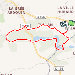
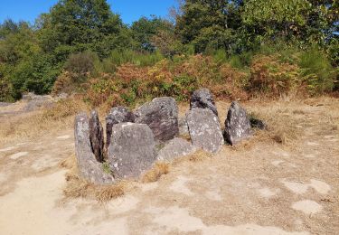
Randonnée Marche de 4 km à découvrir à Bretagne, Morbihan, Néant-sur-Yvel. Cette randonnée est proposée par sebastienjacqmin.
Description
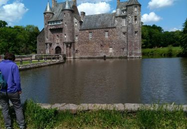
Une superbe marche d’une heure autour des étangs, le long des cours d’eau. À faire en toutes saisons. Petite zone qui peut être humide autour de l’étang de tlohan, en hiver prévoir bottes.
Localisation
Pays :
France
Région :
Bretagne
Département/Province :
Morbihan
Commune :
Néant-sur-Yvel
Localité :
Unknown
Départ:(Dec)
Départ:(UTM)
551497 ; 5317231 (30U) N.
Commentaires
Randonnées à proximité
![Randonnée Randonnée équestre Néant-sur-Yvel - Broceliande - Photo](https://media.geolcdn.com/t/375/260/203abf06-19c3-4c8f-9ce2-990712cb0787.jpg&format=jpg&maxdim=2)
![Randonnée équestre Randonnée équestre](https://static1.geolcdn.com/sitytour/trail-icons/301.png)
Broceliande
Randonnée équestre
Moyen
(1)
Néant-sur-Yvel,
Bretagne,
Morbihan,
France
![](/images/other/stat-length.png)
22 km | 26 km-effort
4h 46min
![](https://static1.geolcdn.com/siteimages/upload/files/16400158638029165_repeat_loop_refresh_sync_direction_icon.png)
Oui
![Randonnée Marche Campénéac - Château de TRECESSON - Tombeau du Géant - L'Hotié de la Fée Viviane - (8/2019) - Photo](https://media.geolcdn.com/t/375/260/6dc55585-1341-4962-8006-32206bea207b.jpg&format=jpg&maxdim=2)
![Marche Marche](https://static1.geolcdn.com/sitytour/trail-icons/101.png)
Château de TRECESSON - Tombeau du Géant - L'Hotié de la Fée Viviane - (8/2019)
Marche
Moyen
(1)
Campénéac,
Bretagne,
Morbihan,
France
![](/images/other/stat-length.png)
11 km | 13,4 km-effort
2h 43min
![](https://static1.geolcdn.com/siteimages/upload/files/16400158638029165_repeat_loop_refresh_sync_direction_icon.png)
Oui
![Randonnée Marche Tréhorenteuc - les landes de Gurwant et le Val sans retour - Photo](https://media.geolcdn.com/t/375/260/8ebdb65c-0df1-4e76-a908-0321b1ff5945.jpg&format=jpg&maxdim=2)
![Marche Marche](https://static1.geolcdn.com/sitytour/trail-icons/101.png)
les landes de Gurwant et le Val sans retour
Marche
Facile
Tréhorenteuc,
Bretagne,
Morbihan,
France
![](/images/other/stat-length.png)
14,9 km | 18,2 km-effort
4h 46min
![](https://static1.geolcdn.com/siteimages/upload/files/16400158638029165_repeat_loop_refresh_sync_direction_icon.png)
Oui
![Randonnée Marche Tréhorenteuc - Tréhorenteuc - Photo](https://media.geolcdn.com/t/375/260/d78e64c2-e4c4-446d-80e9-2d94e7737353.jpg&format=jpg&maxdim=2)
![Marche Marche](https://static1.geolcdn.com/sitytour/trail-icons/101.png)
![Randonnée Marche Mauron - GR_37_CF_40_Mauron_Taupont_20220925 - Photo](https://media.geolcdn.com/t/375/260/5934c0c6-bee8-44fc-9fe2-148a0c004337.jpg&format=jpg&maxdim=2)
![Marche Marche](https://static1.geolcdn.com/sitytour/trail-icons/101.png)
GR_37_CF_40_Mauron_Taupont_20220925
Marche
Très facile
Mauron,
Bretagne,
Morbihan,
France
![](/images/other/stat-length.png)
22 km | 25 km-effort
4h 47min
![](https://static1.geolcdn.com/siteimages/upload/files/16400158638029165_repeat_loop_refresh_sync_direction_icon.png)
Non
![Randonnée Marche Tréhorenteuc - Broceliande - Photo](https://media.geolcdn.com/t/375/260/81018fdd-76b5-4b1a-8652-c9a532731623.jpg&format=jpg&maxdim=2)
![Marche Marche](https://static1.geolcdn.com/sitytour/trail-icons/101.png)
![Randonnée A pied Campénéac - Les Landes de Gurwan - Photo](https://media.geolcdn.com/t/375/260/b737382d-2b17-4f2d-90a4-5777864a81d4.jpeg&format=jpg&maxdim=2)
![A pied A pied](https://static1.geolcdn.com/sitytour/trail-icons/100.png)
Les Landes de Gurwan
A pied
Facile
Campénéac,
Bretagne,
Morbihan,
France
![](/images/other/stat-length.png)
11,4 km | 13,7 km-effort
3h 6min
![](https://static1.geolcdn.com/siteimages/upload/files/16400158638029165_repeat_loop_refresh_sync_direction_icon.png)
Oui
![Randonnée Marche Néant-sur-Yvel - TUMULUS DU JARDIN AUX MOINES (9/20) - Photo](https://media.geolcdn.com/t/375/260/7bb9903b-d90a-4ad2-bb6c-2c00df8bd974.jpg&format=jpg&maxdim=2)
![Marche Marche](https://static1.geolcdn.com/sitytour/trail-icons/101.png)
TUMULUS DU JARDIN AUX MOINES (9/20)
Marche
Moyen
Néant-sur-Yvel,
Bretagne,
Morbihan,
France
![](/images/other/stat-length.png)
11,7 km | 14,2 km-effort
3h 30min
![](https://static1.geolcdn.com/siteimages/upload/files/16400158638029165_repeat_loop_refresh_sync_direction_icon.png)
Oui
![Randonnée Marche Campénéac - l'arbre d'or Val sans retour - Photo](https://media.geolcdn.com/t/375/260/1799521b-97a1-40bd-ba1e-99ab40d78482.jpg&format=jpg&maxdim=2)
![Marche Marche](https://static1.geolcdn.com/sitytour/trail-icons/101.png)
l'arbre d'or Val sans retour
Marche
Moyen
Campénéac,
Bretagne,
Morbihan,
France
![](/images/other/stat-length.png)
13,3 km | 0 m-effort
3h 15min
![](https://static1.geolcdn.com/siteimages/upload/files/16400158638029165_repeat_loop_refresh_sync_direction_icon.png)
Oui