![](/images/other/stat-length.png)
![Randonnée Marche Arrens-Marsous - Col de l'Hospitalet, lac Migouélou en boucle - Photo](https://media.geolcdn.com/t/1900/400/ext.pjpeg?maxdim=2&url=https%3A%2F%2Fstatic1.geolcdn.com%2Fsiteimages%2Fupload%2Ffiles%2F1553511878bg_sport_marche.png)
Col de l'Hospitalet, lac Migouélou en boucle
pacha56
Utilisateur
![Longueur](/images/other/stat-length.png)
Longueur
15,3 km
![Altitude max](https://static1.geolcdn.com/siteimages/upload/files/1508320355ic_sort_altitude_max_24dp.png)
Altitude max
2563 m
![Dénivelé positif](https://static1.geolcdn.com/siteimages/upload/files/1508320355ic_sort_den_pos_24dp.png)
Dénivelé positif
1344 m
![Km-Effort](/images/other/stat-length.png)
Km-Effort
33 km
![Altitude min](https://static1.geolcdn.com/siteimages/upload/files/1508320355ic_sort_altitude_min_24dp.png)
Altitude min
1216 m
![Dénivelé négatif](https://static1.geolcdn.com/siteimages/upload/files/1508320355ic_sort_den_neg_24dp.png)
Dénivelé négatif
1351 m
![Boucle](https://static1.geolcdn.com/siteimages/upload/files/16400158638029165_repeat_loop_refresh_sync_direction_icon.png)
Boucle
Oui
Date de création :
2019-09-12 07:33:51.818
Dernière modification :
2019-09-12 16:20:25.937
![Marche](https://static1.geolcdn.com/sitytour/trail-icons/101.png)
7h22
Difficulté : Difficile
![Scannez ce code QR pour ouvrir la randonnée dans l'application SityTrail](https://capi.geolives.com/qq0zvz2zws4bq2lad0pu/sitytour/trails/2200126/qr.png?size=200)
Application GPS de randonnée GRATUITE
À propos
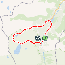
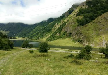
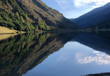
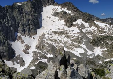
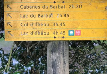
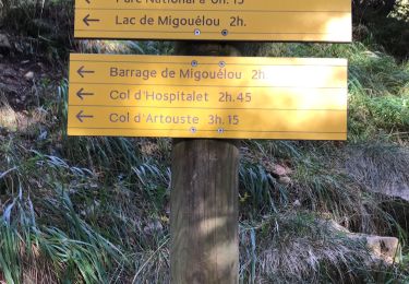
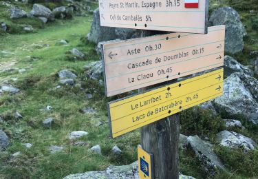
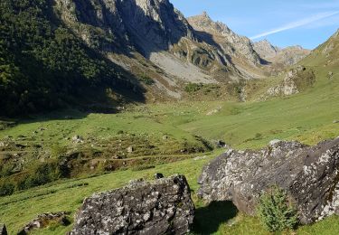
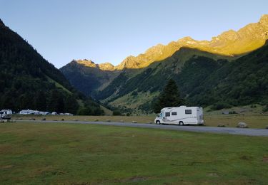
Randonnée Marche de 15,3 km à découvrir à Occitanie, Hautes-Pyrénées, Arrens-Marsous. Cette randonnée est proposée par pacha56.
Description
Belle randonnée, le début est long avant d'arriver au lac Migouélou, pas mal de pierriers à la descente.. belles vues et mûres, myrtilles et framboises à déguster...
Localisation
Pays :
France
Région :
Occitanie
Département/Province :
Hautes-Pyrénées
Commune :
Arrens-Marsous
Localité :
Unknown
Départ:(Dec)
Départ:(UTM)
722807 ; 4752191 (30T) N.
Commentaires
Randonnées à proximité
![Randonnée Marche Estaing - ESTAING RS le der de 2022 - Photo](https://media.geolcdn.com/t/375/260/0404f897-2945-4225-b4b6-dbaf65ce5d84.jpg&format=jpg&maxdim=2)
![Marche Marche](https://static1.geolcdn.com/sitytour/trail-icons/101.png)
ESTAING RS le der de 2022
Marche
Facile
Estaing,
Occitanie,
Hautes-Pyrénées,
France
![](/images/other/stat-length.png)
3,6 km | 5,1 km-effort
1h 5min
![](https://static1.geolcdn.com/siteimages/upload/files/16400158638029165_repeat_loop_refresh_sync_direction_icon.png)
Oui
![Randonnée Marche Estaing - Ruines et lac de Liantran - Photo](https://media.geolcdn.com/t/375/260/1b91bce4-1111-454c-9093-1e2ab24d6024.jpg&format=jpg&maxdim=2)
![Marche Marche](https://static1.geolcdn.com/sitytour/trail-icons/101.png)
Ruines et lac de Liantran
Marche
Facile
Estaing,
Occitanie,
Hautes-Pyrénées,
France
![](/images/other/stat-length.png)
17,7 km | 28 km-effort
6h 45min
![](https://static1.geolcdn.com/siteimages/upload/files/16400158638029165_repeat_loop_refresh_sync_direction_icon.png)
Oui
![Randonnée Marche Arrens-Marsous - pic de cristayet - Photo](https://media.geolcdn.com/t/375/260/4c1e26d5-197f-441e-9709-6adb4628c945.jpg&format=jpg&maxdim=2)
![Marche Marche](https://static1.geolcdn.com/sitytour/trail-icons/101.png)
pic de cristayet
Marche
Difficile
Arrens-Marsous,
Occitanie,
Hautes-Pyrénées,
France
![](/images/other/stat-length.png)
15,7 km | 35 km-effort
9h 32min
![](https://static1.geolcdn.com/siteimages/upload/files/16400158638029165_repeat_loop_refresh_sync_direction_icon.png)
Oui
![Randonnée Marche Estaing - Pyrénées jour 4 - Photo](https://media.geolcdn.com/t/375/260/5c6b756a-151d-456f-a813-d2eed350fb7d.jpg&format=jpg&maxdim=2)
![Marche Marche](https://static1.geolcdn.com/sitytour/trail-icons/101.png)
Pyrénées jour 4
Marche
Estaing,
Occitanie,
Hautes-Pyrénées,
France
![](/images/other/stat-length.png)
12,6 km | 22 km-effort
4h 6min
![](https://static1.geolcdn.com/siteimages/upload/files/16400158638029165_repeat_loop_refresh_sync_direction_icon.png)
Oui
![Randonnée Marche Arrens-Marsous - Pyrénées jour 3 - Photo](https://media.geolcdn.com/t/375/260/f0337aed-7c8f-4a4e-8cd6-fd5a1a5be425.jpg&format=jpg&maxdim=2)
![Marche Marche](https://static1.geolcdn.com/sitytour/trail-icons/101.png)
Pyrénées jour 3
Marche
Arrens-Marsous,
Occitanie,
Hautes-Pyrénées,
France
![](/images/other/stat-length.png)
9,7 km | 22 km-effort
5h 41min
![](https://static1.geolcdn.com/siteimages/upload/files/16400158638029165_repeat_loop_refresh_sync_direction_icon.png)
Oui
![Randonnée Marche Arrens-Marsous - Pyrénées jour 2 - Photo](https://media.geolcdn.com/t/375/260/47560504-9532-4271-bcaa-9f510a9d197b.jpg&format=jpg&maxdim=2)
![Marche Marche](https://static1.geolcdn.com/sitytour/trail-icons/101.png)
Pyrénées jour 2
Marche
Arrens-Marsous,
Occitanie,
Hautes-Pyrénées,
France
![](/images/other/stat-length.png)
13 km | 23 km-effort
7h 0min
![](https://static1.geolcdn.com/siteimages/upload/files/16400158638029165_repeat_loop_refresh_sync_direction_icon.png)
Oui
![Randonnée Marche Arrens-Marsous - Tech - Ausseila. - Photo](https://media.geolcdn.com/t/375/260/12428191-124f-4fd1-ab66-0d522905b93b.jpg&format=jpg&maxdim=2)
![Marche Marche](https://static1.geolcdn.com/sitytour/trail-icons/101.png)
Tech - Ausseila.
Marche
Moyen
Arrens-Marsous,
Occitanie,
Hautes-Pyrénées,
France
![](/images/other/stat-length.png)
14,3 km | 28 km-effort
8h 39min
![](https://static1.geolcdn.com/siteimages/upload/files/16400158638029165_repeat_loop_refresh_sync_direction_icon.png)
Oui
![Randonnée Marche Arrens-Marsous - Refuge de LARRIBET - Photo](https://media.geolcdn.com/t/375/260/a45753d2-1ce8-41ec-9fa9-20d3b65809a7.jpg&format=jpg&maxdim=2)
![Marche Marche](https://static1.geolcdn.com/sitytour/trail-icons/101.png)
Refuge de LARRIBET
Marche
Moyen
Arrens-Marsous,
Occitanie,
Hautes-Pyrénées,
France
![](/images/other/stat-length.png)
12,2 km | 20 km-effort
5h 57min
![](https://static1.geolcdn.com/siteimages/upload/files/16400158638029165_repeat_loop_refresh_sync_direction_icon.png)
Oui
![Randonnée Marche Estaing - Circulaire lac Estaing par brèche de Hourat - Photo](https://media.geolcdn.com/t/375/260/26209189-3d34-4e85-887a-a4af7697d195.jpg&format=jpg&maxdim=2)
![Marche Marche](https://static1.geolcdn.com/sitytour/trail-icons/101.png)
Circulaire lac Estaing par brèche de Hourat
Marche
Très difficile
Estaing,
Occitanie,
Hautes-Pyrénées,
France
![](/images/other/stat-length.png)
23 km | 46 km-effort
15h 45min
![](https://static1.geolcdn.com/siteimages/upload/files/16400158638029165_repeat_loop_refresh_sync_direction_icon.png)
Oui