![](/images/other/stat-length.png)
![Randonnée Marche Argenton-sur-Creuse - Argenton -Gargilesse - Photo](https://media.geolcdn.com/t/1900/400/ext.pjpeg?maxdim=2&url=https%3A%2F%2Fstatic1.geolcdn.com%2Fsiteimages%2Fupload%2Ffiles%2F1553511878bg_sport_marche.png)
Argenton -Gargilesse
pgeiger
Utilisateur
![Longueur](/images/other/stat-length.png)
Longueur
16 km
![Altitude max](https://static1.geolcdn.com/siteimages/upload/files/1508320355ic_sort_altitude_max_24dp.png)
Altitude max
196 m
![Dénivelé positif](https://static1.geolcdn.com/siteimages/upload/files/1508320355ic_sort_den_pos_24dp.png)
Dénivelé positif
256 m
![Km-Effort](/images/other/stat-length.png)
Km-Effort
19,3 km
![Altitude min](https://static1.geolcdn.com/siteimages/upload/files/1508320355ic_sort_altitude_min_24dp.png)
Altitude min
105 m
![Dénivelé négatif](https://static1.geolcdn.com/siteimages/upload/files/1508320355ic_sort_den_neg_24dp.png)
Dénivelé négatif
214 m
![Boucle](https://static1.geolcdn.com/siteimages/upload/files/16400158638029165_repeat_loop_refresh_sync_direction_icon.png)
Boucle
Non
Date de création :
2019-09-09 08:14:56.0
Dernière modification :
2019-09-09 15:25:30.372
![Marche](https://static1.geolcdn.com/sitytour/trail-icons/101.png)
6h56
Difficulté : Facile
![Scannez ce code QR pour ouvrir la randonnée dans l'application SityTrail](https://capi.geolives.com/qq0zvz2zws4bq2lad0pu/sitytour/trails/2196472/qr.png?size=200)
Application GPS de randonnée GRATUITE
À propos
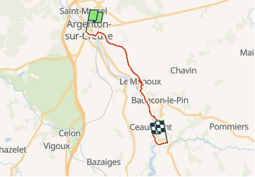
Randonnée Marche de 16 km à découvrir à Centre-Val de Loire, Indre, Argenton-sur-Creuse. Cette randonnée est proposée par pgeiger.
Description
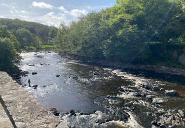
Longue sortie d’Argenton, il vaut mieux prendre l’option rive gauche. 6h 56 parce qu’arrêter assez long au Menoux pour visiter l’église et l’atelier du sculpteur et arrêt déjeuner prolongé au bord de la creuse...
Localisation
Pays :
France
Région :
Centre-Val de Loire
Département/Province :
Indre
Commune :
Argenton-sur-Creuse
Localité :
Unknown
Départ:(Dec)
Départ:(UTM)
386396 ; 5160278 (31T) N.
Commentaires
Randonnées à proximité
![Randonnée V.T.T. Le Menoux - Vallée de la Creuse 1 - Photo](https://media.geolcdn.com/t/375/260/ext.jpg?maxdim=2&url=https%3A%2F%2Fstatic1.geolcdn.com%2Fsiteimages%2Fupload%2Ffiles%2F1524743154velo.jpg)
![V.T.T. V.T.T.](https://static1.geolcdn.com/sitytour/trail-icons/202.png)
Vallée de la Creuse 1
V.T.T.
Moyen
(1)
Le Menoux,
Centre-Val de Loire,
Indre,
France
![](/images/other/stat-length.png)
51 km | 63 km-effort
Inconnu
![](https://static1.geolcdn.com/siteimages/upload/files/16400158638029165_repeat_loop_refresh_sync_direction_icon.png)
Non
![Randonnée sport Le Menoux - Sob 17 le menoux cuzion - Photo](https://media.geolcdn.com/t/375/260/a7ea09a4-f376-4dab-a4f6-85126f46f916.jpg&format=jpg&maxdim=2)
Sob 17 le menoux cuzion
sport
Très facile
Le Menoux,
Centre-Val de Loire,
Indre,
France
![](/images/other/stat-length.png)
16,6 km | 21 km-effort
Inconnu
![](https://static1.geolcdn.com/siteimages/upload/files/16400158638029165_repeat_loop_refresh_sync_direction_icon.png)
Non
![Randonnée sport Argenton-sur-Creuse - Sob 17 argenton le menoux - Photo](https://media.geolcdn.com/t/375/260/f0e88c99-83b7-4f39-964f-dc35c2f4422f.jpg&format=jpg&maxdim=2)
Sob 17 argenton le menoux
sport
Très facile
Argenton-sur-Creuse,
Centre-Val de Loire,
Indre,
France
![](/images/other/stat-length.png)
8,3 km | 9,5 km-effort
Inconnu
![](https://static1.geolcdn.com/siteimages/upload/files/16400158638029165_repeat_loop_refresh_sync_direction_icon.png)
Non
![Randonnée Marche Argenton-sur-Creuse - SityTrail - Argenton sur Creuse - le Menoux - Photo](https://media.geolcdn.com/t/375/260/ext.jpg?maxdim=2&url=https%3A%2F%2Fstatic1.geolcdn.com%2Fsiteimages%2Fupload%2Ffiles%2F1553511878bg_sport_marche.png)
![Marche Marche](https://static1.geolcdn.com/sitytour/trail-icons/101.png)
SityTrail - Argenton sur Creuse - le Menoux
Marche
Très difficile
Argenton-sur-Creuse,
Centre-Val de Loire,
Indre,
France
![](/images/other/stat-length.png)
21 km | 25 km-effort
5h 45min
![](https://static1.geolcdn.com/siteimages/upload/files/16400158638029165_repeat_loop_refresh_sync_direction_icon.png)
Oui
![Randonnée Vélo de route Argenton-sur-Creuse - Autour de la vallée de la Creuse à vélo - Photo](https://media.geolcdn.com/t/375/260/ext.jpg?maxdim=2&url=https%3A%2F%2Fstatic1.geolcdn.com%2Fsiteimages%2Fupload%2Ffiles%2F1524743154velo.jpg)
![Vélo de route Vélo de route](https://static1.geolcdn.com/sitytour/trail-icons/201.png)
Autour de la vallée de la Creuse à vélo
Vélo de route
Très difficile
Argenton-sur-Creuse,
Centre-Val de Loire,
Indre,
France
![](/images/other/stat-length.png)
75 km | 90 km-effort
5h 14min
![](https://static1.geolcdn.com/siteimages/upload/files/16400158638029165_repeat_loop_refresh_sync_direction_icon.png)
Oui
![Randonnée Marche Argenton-sur-Creuse - La Penoterie - Photo](https://media.geolcdn.com/t/375/260/ext.jpg?maxdim=2&url=https%3A%2F%2Fstatic1.geolcdn.com%2Fsiteimages%2Fupload%2Ffiles%2F1553511878bg_sport_marche.png)
![Marche Marche](https://static1.geolcdn.com/sitytour/trail-icons/101.png)
La Penoterie
Marche
Facile
Argenton-sur-Creuse,
Centre-Val de Loire,
Indre,
France
![](/images/other/stat-length.png)
10,9 km | 14,3 km-effort
3h 3min
![](https://static1.geolcdn.com/siteimages/upload/files/16400158638029165_repeat_loop_refresh_sync_direction_icon.png)
Oui
![Randonnée Marche Argenton-sur-Creuse - VEZ-12a-Argenton sur Creuse-Gargilesse - Photo](https://media.geolcdn.com/t/375/260/ext.jpg?maxdim=2&url=https%3A%2F%2Fstatic1.geolcdn.com%2Fsiteimages%2Fupload%2Ffiles%2F1553511878bg_sport_marche.png)
![Marche Marche](https://static1.geolcdn.com/sitytour/trail-icons/101.png)
VEZ-12a-Argenton sur Creuse-Gargilesse
Marche
Facile
Argenton-sur-Creuse,
Centre-Val de Loire,
Indre,
France
![](/images/other/stat-length.png)
12,4 km | 15,3 km-effort
Inconnu
![](https://static1.geolcdn.com/siteimages/upload/files/16400158638029165_repeat_loop_refresh_sync_direction_icon.png)
Non
![Randonnée Marche Le Pont-Chrétien-Chabenet - LE PONT-CHRETIEN-CHABENET Entre ponts et châteaux - Photo](https://media.geolcdn.com/t/375/260/ext.jpg?maxdim=2&url=https%3A%2F%2Fstatic1.geolcdn.com%2Fsiteimages%2Fupload%2Ffiles%2F1553511878bg_sport_marche.png)
![Marche Marche](https://static1.geolcdn.com/sitytour/trail-icons/101.png)
LE PONT-CHRETIEN-CHABENET Entre ponts et châteaux
Marche
Moyen
Le Pont-Chrétien-Chabenet,
Centre-Val de Loire,
Indre,
France
![](/images/other/stat-length.png)
8,9 km | 10,5 km-effort
2h 22min
![](https://static1.geolcdn.com/siteimages/upload/files/16400158638029165_repeat_loop_refresh_sync_direction_icon.png)
Oui
![Randonnée Marche Le Pont-Chrétien-Chabenet - Entre ponts et châteaux (Le pont-chrétien-Chabenet) - Photo](https://media.geolcdn.com/t/375/260/ext.jpg?maxdim=2&url=https%3A%2F%2Fstatic1.geolcdn.com%2Fsiteimages%2Fupload%2Ffiles%2F1553511878bg_sport_marche.png)
![Marche Marche](https://static1.geolcdn.com/sitytour/trail-icons/101.png)
Entre ponts et châteaux (Le pont-chrétien-Chabenet)
Marche
Moyen
Le Pont-Chrétien-Chabenet,
Centre-Val de Loire,
Indre,
France
![](/images/other/stat-length.png)
8,9 km | 10,5 km-effort
2h 23min
![](https://static1.geolcdn.com/siteimages/upload/files/16400158638029165_repeat_loop_refresh_sync_direction_icon.png)
Oui