![](/images/other/stat-length.png)
![Randonnée Marche Montréal - Pointe aux Carrières et Île Bizard - Photo](https://media.geolcdn.com/t/1900/400/ext.pjpeg?maxdim=2&url=https%3A%2F%2Fstatic1.geolcdn.com%2Fsiteimages%2Fupload%2Ffiles%2F1553511878bg_sport_marche.png)
Pointe aux Carrières et Île Bizard
Alizée.pee
Utilisateur GUIDE
![Longueur](/images/other/stat-length.png)
Longueur
9,9 km
![Altitude max](https://static1.geolcdn.com/siteimages/upload/files/1508320355ic_sort_altitude_max_24dp.png)
Altitude max
46 m
![Dénivelé positif](https://static1.geolcdn.com/siteimages/upload/files/1508320355ic_sort_den_pos_24dp.png)
Dénivelé positif
110 m
![Km-Effort](/images/other/stat-length.png)
Km-Effort
11,3 km
![Altitude min](https://static1.geolcdn.com/siteimages/upload/files/1508320355ic_sort_altitude_min_24dp.png)
Altitude min
21 m
![Dénivelé négatif](https://static1.geolcdn.com/siteimages/upload/files/1508320355ic_sort_den_neg_24dp.png)
Dénivelé négatif
110 m
![Boucle](https://static1.geolcdn.com/siteimages/upload/files/16400158638029165_repeat_loop_refresh_sync_direction_icon.png)
Boucle
Oui
Date de création :
2019-09-06 14:19:18.418
Dernière modification :
2019-09-06 14:24:42.978
![Marche](https://static1.geolcdn.com/sitytour/trail-icons/101.png)
2h29
Difficulté : Moyen
![Scannez ce code QR pour ouvrir la randonnée dans l'application SityTrail](https://capi.geolives.com/qq0zvz2zws4bq2lad0pu/sitytour/trails/2193453/qr.png?size=200)
Application GPS de randonnée GRATUITE
À propos
Randonnée Marche de 9,9 km à découvrir à Québec, Agglomération de Montréal, Montréal. Cette randonnée est proposée par Alizée.pee.
Description
Sentier se trouvant près de Montréal, qui comprend un lac. La randonnée propose de magnifiques vues sur le lac et elle est très agréable ! Je vous la recommande vivement.
Localisation
Pays :
Canada
Région :
Québec
Département/Province :
Agglomération de Montréal
Commune :
Montréal
Localité :
Unknown
Départ:(Dec)
Départ:(UTM)
585924 ; 5040920 (18T) N.
Commentaires
Randonnées à proximité
![Randonnée Marche Oka - Sommer Calvaire du parc national d'Oka - Photo](https://media.geolcdn.com/t/375/260/ext.jpg?maxdim=2&url=https%3A%2F%2Fstatic1.geolcdn.com%2Fsiteimages%2Fupload%2Ffiles%2F1553511878bg_sport_marche.png)
![Marche Marche](https://static1.geolcdn.com/sitytour/trail-icons/101.png)
Sommer Calvaire du parc national d'Oka
Marche
Difficile
Oka,
Québec,
Deux-Montagnes,
Canada
![](/images/other/stat-length.png)
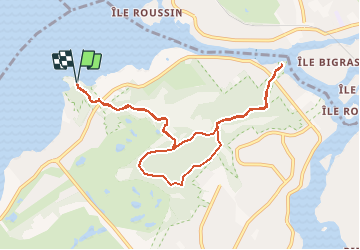
12,3 km | 16,3 km-effort
3h 28min
![](https://static1.geolcdn.com/siteimages/upload/files/16400158638029165_repeat_loop_refresh_sync_direction_icon.png)
Oui
![Randonnée Marche Mirabel - Bois belle riviere - Photo](https://media.geolcdn.com/t/375/260/ext.jpg?maxdim=2&url=https%3A%2F%2Fstatic1.geolcdn.com%2Fsiteimages%2Fupload%2Ffiles%2F1553511878bg_sport_marche.png)
![Marche Marche](https://static1.geolcdn.com/sitytour/trail-icons/101.png)
Bois belle riviere
Marche
Moyen
Mirabel,
Québec,
Inconnu,
Canada
![](/images/other/stat-length.png)
6,3 km | 7,4 km-effort
1h 37min
![](https://static1.geolcdn.com/siteimages/upload/files/16400158638029165_repeat_loop_refresh_sync_direction_icon.png)
Oui
![Randonnée Marche Montréal - Parc Nature du Cap Saint-Jacques -Sentier du Lapin - Photo](https://media.geolcdn.com/t/375/260/ext.jpg?maxdim=2&url=https%3A%2F%2Fstatic1.geolcdn.com%2Fsiteimages%2Fupload%2Ffiles%2F1553511878bg_sport_marche.png)
![Marche Marche](https://static1.geolcdn.com/sitytour/trail-icons/101.png)
Parc Nature du Cap Saint-Jacques -Sentier du Lapin
Marche
Moyen
Montréal,
Québec,
Agglomération de Montréal,
Canada
![](/images/other/stat-length.png)
5,9 km | 6,6 km-effort
1h 27min
![](https://static1.geolcdn.com/siteimages/upload/files/16400158638029165_repeat_loop_refresh_sync_direction_icon.png)
Oui
![Randonnée V.T.T. Mirabel - ben2 - Photo](https://media.geolcdn.com/t/375/260/ext.jpg?maxdim=2&url=https%3A%2F%2Fstatic1.geolcdn.com%2Fsiteimages%2Fupload%2Ffiles%2F1524743154velo.jpg)
![V.T.T. V.T.T.](https://static1.geolcdn.com/sitytour/trail-icons/202.png)
![Randonnée Vélo Mirabel - benoit - Photo](https://media.geolcdn.com/t/375/260/ext.jpg?maxdim=2&url=https%3A%2F%2Fstatic1.geolcdn.com%2Fsiteimages%2Fupload%2Ffiles%2F1524743154velo.jpg)
![Vélo Vélo](https://static1.geolcdn.com/sitytour/trail-icons/200.png)
![Randonnée Vélo électrique Sainte-Anne-de-Bellevue - l'île Perrot - Photo](https://media.geolcdn.com/t/375/260/ext.jpg?maxdim=2&url=https%3A%2F%2Fstatic1.geolcdn.com%2Fsiteimages%2Fupload%2Ffiles%2F1524743154velo.jpg)
![Vélo électrique Vélo électrique](https://static1.geolcdn.com/sitytour/trail-icons/205.png)
l'île Perrot
Vélo électrique
Très facile
Sainte-Anne-de-Bellevue,
Québec,
Agglomération de Montréal,
Canada
![](/images/other/stat-length.png)
18,2 km | 19,5 km-effort
1h 0min
![](https://static1.geolcdn.com/siteimages/upload/files/16400158638029165_repeat_loop_refresh_sync_direction_icon.png)
Non
![Randonnée Marche Sainte-Anne-de-Bellevue - Ste Anne Baie d'Urfé - Photo](https://media.geolcdn.com/t/375/260/b76493de-83e4-43c3-95fd-87dbcfcb63d1.jpg&format=jpg&maxdim=2)
![Marche Marche](https://static1.geolcdn.com/sitytour/trail-icons/101.png)
Ste Anne Baie d'Urfé
Marche
Très facile
Sainte-Anne-de-Bellevue,
Québec,
Agglomération de Montréal,
Canada
![](/images/other/stat-length.png)
2,3 km | 2,5 km-effort
50min
![](https://static1.geolcdn.com/siteimages/upload/files/16400158638029165_repeat_loop_refresh_sync_direction_icon.png)
Non
![Randonnée Voiture Beaconsfield - Baie d'Urfe - Photo](https://media.geolcdn.com/t/375/260/ext.jpg?maxdim=2&url=https%3A%2F%2Fstatic1.geolcdn.com%2Fsiteimages%2Fupload%2Ffiles%2F15247431544x4.jpg)
![Voiture Voiture](https://static1.geolcdn.com/sitytour/trail-icons/401.png)
Baie d'Urfe
Voiture
Très facile
Beaconsfield,
Québec,
Agglomération de Montréal,
Canada
![](/images/other/stat-length.png)
11,8 km | 12,9 km-effort
27min
![](https://static1.geolcdn.com/siteimages/upload/files/16400158638029165_repeat_loop_refresh_sync_direction_icon.png)
Non
![Randonnée Marche Montréal - Montréal 17.08.2019 - Photo](https://media.geolcdn.com/t/375/260/ext.jpg?maxdim=2&url=https%3A%2F%2Fstatic1.geolcdn.com%2Fsiteimages%2Fupload%2Ffiles%2F1553511878bg_sport_marche.png)
![Marche Marche](https://static1.geolcdn.com/sitytour/trail-icons/101.png)
Montréal 17.08.2019
Marche
Montréal,
Québec,
Agglomération de Montréal,
Canada
![](/images/other/stat-length.png)
3,1 km | 3,5 km-effort
1h 23min
![](https://static1.geolcdn.com/siteimages/upload/files/16400158638029165_repeat_loop_refresh_sync_direction_icon.png)
Oui