![](/images/other/stat-length.png)
![Randonnée Marche Labelle - Green Mountain - Photo](https://media.geolcdn.com/t/1900/400/ext.pjpeg?maxdim=2&url=https%3A%2F%2Fstatic1.geolcdn.com%2Fsiteimages%2Fupload%2Ffiles%2F1553511878bg_sport_marche.png)
Green Mountain
Alizée.pee
Utilisateur GUIDE
![Longueur](/images/other/stat-length.png)
Longueur
4,8 km
![Altitude max](https://static1.geolcdn.com/siteimages/upload/files/1508320355ic_sort_altitude_max_24dp.png)
Altitude max
480 m
![Dénivelé positif](https://static1.geolcdn.com/siteimages/upload/files/1508320355ic_sort_den_pos_24dp.png)
Dénivelé positif
212 m
![Km-Effort](/images/other/stat-length.png)
Km-Effort
7,6 km
![Altitude min](https://static1.geolcdn.com/siteimages/upload/files/1508320355ic_sort_altitude_min_24dp.png)
Altitude min
279 m
![Dénivelé négatif](https://static1.geolcdn.com/siteimages/upload/files/1508320355ic_sort_den_neg_24dp.png)
Dénivelé négatif
210 m
![Boucle](https://static1.geolcdn.com/siteimages/upload/files/16400158638029165_repeat_loop_refresh_sync_direction_icon.png)
Boucle
Oui
Date de création :
2019-09-06 13:50:18.685
Dernière modification :
2019-09-06 13:50:59.231
![Marche](https://static1.geolcdn.com/sitytour/trail-icons/101.png)
1h33
Difficulté : Moyen
![Scannez ce code QR pour ouvrir la randonnée dans l'application SityTrail](https://capi.geolives.com/qq0zvz2zws4bq2lad0pu/sitytour/trails/2193398/qr.png?size=200)
Application GPS de randonnée GRATUITE
À propos
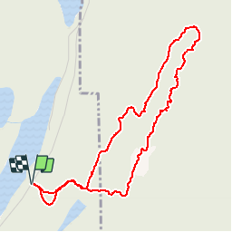
Randonnée Marche de 4,8 km à découvrir à Québec, Les Laurentides, Labelle. Cette randonnée est proposée par Alizée.pee.
Description
c’est un sentier très sympathique avec plusieurs points de vue sur gros rocher, sur les montagnes ainsi que les lacs environnants. C’est une randonnée assez courte, facile à faire avec des enfants. La piste avait de nombreux belvédères magnifiques. Se situe près de Labelle.
Localisation
Pays :
Canada
Région :
Québec
Département/Province :
Les Laurentides
Commune :
Labelle
Localité :
Unknown
Départ:(Dec)
Départ:(UTM)
524453 ; 5121975 (18T) N.
Commentaires
Randonnées à proximité
![Randonnée Marche Labelle - Montagne verte et nez de l'indien - Photo](https://media.geolcdn.com/t/375/260/ext.jpg?maxdim=2&url=https%3A%2F%2Fstatic1.geolcdn.com%2Fsiteimages%2Fupload%2Ffiles%2F1553511878bg_sport_marche.png)
![Marche Marche](https://static1.geolcdn.com/sitytour/trail-icons/101.png)
Montagne verte et nez de l'indien
Marche
Difficile
Labelle,
Québec,
Les Laurentides,
Canada
![](/images/other/stat-length.png)
12,4 km | 21 km-effort
4h 14min
![](https://static1.geolcdn.com/siteimages/upload/files/16400158638029165_repeat_loop_refresh_sync_direction_icon.png)
Oui
![Randonnée Canoë - kayak Labelle - Rivière Rouge - Photo](https://media.geolcdn.com/t/375/260/ext.jpg?maxdim=2&url=https%3A%2F%2Fsecurestorage.geolives.com%2Fsitytour%2Ftrail-bg%2Fdefault.jpg)
![Canoë - kayak Canoë - kayak](https://static1.geolcdn.com/sitytour/trail-icons/703.png)
Rivière Rouge
Canoë - kayak
Moyen
Labelle,
Québec,
Les Laurentides,
Canada
![](/images/other/stat-length.png)
25 km | 27 km-effort
4h 10min
![](https://static1.geolcdn.com/siteimages/upload/files/16400158638029165_repeat_loop_refresh_sync_direction_icon.png)
Non