![](/images/other/stat-length.png)
![Randonnée Marche Plateau-des-Petites-Roches - Col de Marcieu, Pas de Ragris - Photo](https://media.geolcdn.com/t/1900/400/ext.pjpeg?maxdim=2&url=https%3A%2F%2Fstatic1.geolcdn.com%2Fsiteimages%2Fupload%2Ffiles%2F1553511878bg_sport_marche.png)
Col de Marcieu, Pas de Ragris
algecko
Utilisateur
![Longueur](/images/other/stat-length.png)
Longueur
13,3 km
![Altitude max](https://static1.geolcdn.com/siteimages/upload/files/1508320355ic_sort_altitude_max_24dp.png)
Altitude max
1919 m
![Dénivelé positif](https://static1.geolcdn.com/siteimages/upload/files/1508320355ic_sort_den_pos_24dp.png)
Dénivelé positif
1021 m
![Km-Effort](/images/other/stat-length.png)
Km-Effort
27 km
![Altitude min](https://static1.geolcdn.com/siteimages/upload/files/1508320355ic_sort_altitude_min_24dp.png)
Altitude min
1069 m
![Dénivelé négatif](https://static1.geolcdn.com/siteimages/upload/files/1508320355ic_sort_den_neg_24dp.png)
Dénivelé négatif
1023 m
![Boucle](https://static1.geolcdn.com/siteimages/upload/files/16400158638029165_repeat_loop_refresh_sync_direction_icon.png)
Boucle
Oui
Date de création :
2019-09-06 06:56:00.0
Dernière modification :
2019-09-08 10:13:01.559
![Marche](https://static1.geolcdn.com/sitytour/trail-icons/101.png)
5h50
Difficulté : Très difficile
![Scannez ce code QR pour ouvrir la randonnée dans l'application SityTrail](https://capi.geolives.com/qq0zvz2zws4bq2lad0pu/sitytour/trails/2193344/qr.png?size=200)
Application GPS de randonnée GRATUITE
À propos
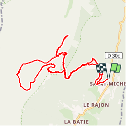
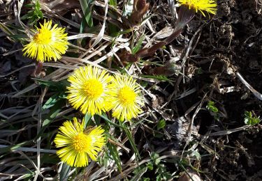
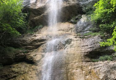
Randonnée Marche de 13,3 km à découvrir à Auvergne-Rhône-Alpes, Isère, Plateau-des-Petites-Roches. Cette randonnée est proposée par algecko.
Description
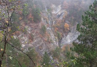
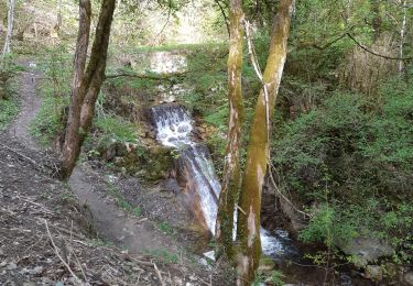
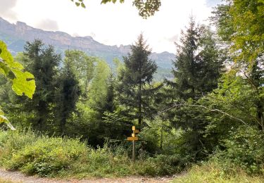
Col de Marcieu, pas de Ragris (fin de la montée périlleuse), antenne radio, alpage de l'Aulp du Seuil, passage de l'Aulp du Seuil. Faire attention à la montée et la descente.
Localisation
Pays :
France
Région :
Auvergne-Rhône-Alpes
Département/Province :
Isère
Commune :
Plateau-des-Petites-Roches
Localité :
Saint-Bernard
Départ:(Dec)
Départ:(UTM)
728462 ; 5026486 (31T) N.
Commentaires
Randonnées à proximité
![Randonnée Marche La Terrasse - Les Cascades du Glesy et le Belvédère du Puy - Photo](https://media.geolcdn.com/t/375/260/ext.jpg?maxdim=2&url=https%3A%2F%2Fservices.sitytrail.com%2FGeolivesWS%2FDownloadMedia.ashx%3FTrailID%3D859792%26Media%3Dfix__20171109135601.jpg)
![Marche Marche](https://static1.geolcdn.com/sitytour/trail-icons/101.png)
Les Cascades du Glesy et le Belvédère du Puy
Marche
Moyen
(1)
La Terrasse,
Auvergne-Rhône-Alpes,
Isère,
France
![](/images/other/stat-length.png)
9,1 km | 18,6 km-effort
3h 55min
![](https://static1.geolcdn.com/siteimages/upload/files/16400158638029165_repeat_loop_refresh_sync_direction_icon.png)
Oui
![Randonnée Marche Plateau-des-Petites-Roches - Piton et Dôme de Bellefont - Photo](https://media.geolcdn.com/t/375/260/ext.jpg?maxdim=2&url=https%3A%2F%2Fservices.sitytrail.com%2FGeolivesWS%2FDownloadMedia.ashx%3FTrailID%3D101446%26Media%3D1519_1.jpg)
![Marche Marche](https://static1.geolcdn.com/sitytour/trail-icons/101.png)
Piton et Dôme de Bellefont
Marche
Difficile
(1)
Plateau-des-Petites-Roches,
Auvergne-Rhône-Alpes,
Isère,
France
![](/images/other/stat-length.png)
10,1 km | 24 km-effort
6h 45min
![](https://static1.geolcdn.com/siteimages/upload/files/16400158638029165_repeat_loop_refresh_sync_direction_icon.png)
Oui
![Randonnée Marche Saint-Vincent-de-Mercuze - 38 cascades d alloix - Photo](https://media.geolcdn.com/t/375/260/ac959965-e9e6-43ac-868c-d1afc5ef4777.jpg&format=jpg&maxdim=2)
![Marche Marche](https://static1.geolcdn.com/sitytour/trail-icons/101.png)
38 cascades d alloix
Marche
Moyen
Saint-Vincent-de-Mercuze,
Auvergne-Rhône-Alpes,
Isère,
France
![](/images/other/stat-length.png)
10,7 km | 20 km-effort
5h 42min
![](https://static1.geolcdn.com/siteimages/upload/files/16400158638029165_repeat_loop_refresh_sync_direction_icon.png)
Non
![Randonnée Marche Plateau-des-Petites-Roches - Dent de Crolles tour - Photo](https://media.geolcdn.com/t/375/260/ext.jpg?maxdim=2&url=https%3A%2F%2Fstatic1.geolcdn.com%2Fsiteimages%2Fupload%2Ffiles%2F1553511878bg_sport_marche.png)
![Marche Marche](https://static1.geolcdn.com/sitytour/trail-icons/101.png)
Dent de Crolles tour
Marche
Très facile
(1)
Plateau-des-Petites-Roches,
Auvergne-Rhône-Alpes,
Isère,
France
![](/images/other/stat-length.png)
14,2 km | 32 km-effort
8h 33min
![](https://static1.geolcdn.com/siteimages/upload/files/16400158638029165_repeat_loop_refresh_sync_direction_icon.png)
Oui
![Randonnée Marche La Terrasse - 38 croix coquet - Photo](https://media.geolcdn.com/t/375/260/b4142c47-b708-48d1-bde5-f071ad1815cd.jpg&format=jpg&maxdim=2)
![Marche Marche](https://static1.geolcdn.com/sitytour/trail-icons/101.png)
38 croix coquet
Marche
Difficile
La Terrasse,
Auvergne-Rhône-Alpes,
Isère,
France
![](/images/other/stat-length.png)
13,1 km | 25 km-effort
6h 12min
![](https://static1.geolcdn.com/siteimages/upload/files/16400158638029165_repeat_loop_refresh_sync_direction_icon.png)
Non
![Randonnée Marche Saint-Vincent-de-Mercuze - Grande cascade de Montalieu - Photo](https://media.geolcdn.com/t/375/260/ext.jpg?maxdim=2&url=https%3A%2F%2Fstatic1.geolcdn.com%2Fsiteimages%2Fupload%2Ffiles%2F1553511878bg_sport_marche.png)
![Marche Marche](https://static1.geolcdn.com/sitytour/trail-icons/101.png)
Grande cascade de Montalieu
Marche
Moyen
(1)
Saint-Vincent-de-Mercuze,
Auvergne-Rhône-Alpes,
Isère,
France
![](/images/other/stat-length.png)
8,5 km | 13,5 km-effort
2h 33min
![](https://static1.geolcdn.com/siteimages/upload/files/16400158638029165_repeat_loop_refresh_sync_direction_icon.png)
Oui
![Randonnée Marche Plateau-des-Petites-Roches - Cascade du Douix - Photo](https://media.geolcdn.com/t/375/260/3a1b7b7d-55bf-4975-b1cc-5364380d6d1a.jpg&format=jpg&maxdim=2)
![Marche Marche](https://static1.geolcdn.com/sitytour/trail-icons/101.png)
Cascade du Douix
Marche
Moyen
Plateau-des-Petites-Roches,
Auvergne-Rhône-Alpes,
Isère,
France
![](/images/other/stat-length.png)
5,4 km | 7 km-effort
2h 11min
![](https://static1.geolcdn.com/siteimages/upload/files/16400158638029165_repeat_loop_refresh_sync_direction_icon.png)
Non
![Randonnée Marche Plateau-des-Petites-Roches - Cabane de l'Aulp du Seuil au part du col de Marcieu - Photo](https://media.geolcdn.com/t/375/260/2eee0c8f-e00c-49d7-8e11-2f874442064a.jpg&format=jpg&maxdim=2)
![Marche Marche](https://static1.geolcdn.com/sitytour/trail-icons/101.png)
Cabane de l'Aulp du Seuil au part du col de Marcieu
Marche
Moyen
Plateau-des-Petites-Roches,
Auvergne-Rhône-Alpes,
Isère,
France
![](/images/other/stat-length.png)
9,5 km | 22 km-effort
3h 35min
![](https://static1.geolcdn.com/siteimages/upload/files/16400158638029165_repeat_loop_refresh_sync_direction_icon.png)
Oui
![Randonnée Marche Saint-Vincent-de-Mercuze - Cascades de l’Alloix Montalieu - Photo](https://media.geolcdn.com/t/375/260/8601530d-e476-4556-ae2d-7b5494f9bf11.jpg&format=jpg&maxdim=2)
![Marche Marche](https://static1.geolcdn.com/sitytour/trail-icons/101.png)
Cascades de l’Alloix Montalieu
Marche
Difficile
Saint-Vincent-de-Mercuze,
Auvergne-Rhône-Alpes,
Isère,
France
![](/images/other/stat-length.png)
13,6 km | 23 km-effort
3h 52min
![](https://static1.geolcdn.com/siteimages/upload/files/16400158638029165_repeat_loop_refresh_sync_direction_icon.png)
Oui