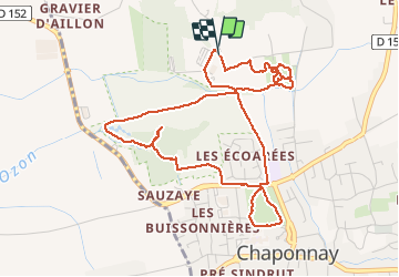
![](/images/other/stat-length.png)
![Randonnée Marche Chaponnay - Chaponnay-Ecoarees 6 a 49 - Photo](https://media.geolcdn.com/t/1900/400/ext.pjpeg?maxdim=2&url=https%3A%2F%2Fstatic1.geolcdn.com%2Fsiteimages%2Fupload%2Ffiles%2F1553511878bg_sport_marche.png)
Chaponnay-Ecoarees 6 a 49
jtraverse
Utilisateur
![Longueur](/images/other/stat-length.png)
![Altitude max](https://static1.geolcdn.com/siteimages/upload/files/1508320355ic_sort_altitude_max_24dp.png)
![Dénivelé positif](https://static1.geolcdn.com/siteimages/upload/files/1508320355ic_sort_den_pos_24dp.png)
![Km-Effort](/images/other/stat-length.png)
![Altitude min](https://static1.geolcdn.com/siteimages/upload/files/1508320355ic_sort_altitude_min_24dp.png)
![Dénivelé négatif](https://static1.geolcdn.com/siteimages/upload/files/1508320355ic_sort_den_neg_24dp.png)
![Boucle](https://static1.geolcdn.com/siteimages/upload/files/16400158638029165_repeat_loop_refresh_sync_direction_icon.png)
![Marche](https://static1.geolcdn.com/sitytour/trail-icons/101.png)
2h45
Difficulté : Facile
![Scannez ce code QR pour ouvrir la randonnée dans l'application SityTrail](https://capi.geolives.com/qq0zvz2zws4bq2lad0pu/sitytour/trails/2190637/qr.png?size=200)
Application GPS de randonnée GRATUITE
À propos
Randonnée Marche de 5,7 km à découvrir à Auvergne-Rhône-Alpes, Rhône, Chaponnay. Cette randonnée est proposée par jtraverse.
Description
Chaponnay-Ecoarées Trajet voiture 9.4km 17min
GPS Pk 45.6388,4.9287 ou 45°38'16"N 4°55'43"E
Trajet du 5 rue de l’Egalité : 9.4km 16 mn
• Sortir du parking à gauche, suivre la rue de l’Egalité jusqu’au bout, jusqu’au gros rond-point
• Prendre la 3e sortie sur route de MIONS, direction MIONS-Centre, continuer jusqu’à la sortie de MIONS Au rond-point, prendre la 1re sortie sur Rue Salvador Allende/D149
• Au rond-point, prendre à gauche Route de Chaponnay/D152, dans Chaponnay la D152 tourne à droite (chemin de l’Ozon) le suivre sur 750m, puis tourner à gauche rue du Stade .Le parking sera sur la droite.
notes :
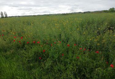
1 - Des tables de pique nique et des bancs ont été installés en 2019 dans la zone du parcours de santé
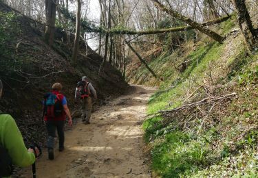
2- Le détour vers le nord nous a permis de voir que le passage est fermé par des barbelés
3 - le détour vers le nord-est nous a permis de repérer un chemin qui n'apparaît pas sur la carte
Localisation
Commentaires
Randonnées à proximité
![Randonnée Marche Marennes - 69 marennes-villette-V2-17km-420m - Photo](https://media.geolcdn.com/t/375/260/25f97240-4655-4bff-897e-e00f442ce49e.jpg&format=jpg&maxdim=2)
![Marche Marche](https://static1.geolcdn.com/sitytour/trail-icons/101.png)
Marche
![](/images/other/stat-length.png)
![](https://static1.geolcdn.com/siteimages/upload/files/16400158638029165_repeat_loop_refresh_sync_direction_icon.png)
![Randonnée V.T.T. Chaponnay - Chaponnay - Valencin - Photo](https://media.geolcdn.com/t/375/260/ext.jpg?maxdim=2&url=https%3A%2F%2Fstatic1.geolcdn.com%2Fsiteimages%2Fupload%2Ffiles%2F1524743154velo.jpg)
![V.T.T. V.T.T.](https://static1.geolcdn.com/sitytour/trail-icons/202.png)
V.T.T.
![](/images/other/stat-length.png)
![](https://static1.geolcdn.com/siteimages/upload/files/16400158638029165_repeat_loop_refresh_sync_direction_icon.png)
![Randonnée A pied Feyzin - Sentier des Alouettes - Photo](https://media.geolcdn.com/t/375/260/196abbf9-cf3c-423e-8745-e82f535258da.jpeg&format=jpg&maxdim=2)
![A pied A pied](https://static1.geolcdn.com/sitytour/trail-icons/100.png)
A pied
![](/images/other/stat-length.png)
![](https://static1.geolcdn.com/siteimages/upload/files/16400158638029165_repeat_loop_refresh_sync_direction_icon.png)
![Randonnée Marche Chaponnay - 69-chaponnay-a-luzinay-20KM-430m-sensH-mai21 - Photo](https://media.geolcdn.com/t/375/260/b9109f10-61ca-47fa-8b0f-ffddb86e6f59.jpg&format=jpg&maxdim=2)
![Marche Marche](https://static1.geolcdn.com/sitytour/trail-icons/101.png)
Marche
![](/images/other/stat-length.png)
![](https://static1.geolcdn.com/siteimages/upload/files/16400158638029165_repeat_loop_refresh_sync_direction_icon.png)
![Randonnée V.T.T. Corbas - Corbas bois de st jean - Photo](https://media.geolcdn.com/t/375/260/ce84024e-6114-4bc0-bf26-193adabf40f8.jpg&format=jpg&maxdim=2)
![V.T.T. V.T.T.](https://static1.geolcdn.com/sitytour/trail-icons/202.png)
V.T.T.
![](/images/other/stat-length.png)
![](https://static1.geolcdn.com/siteimages/upload/files/16400158638029165_repeat_loop_refresh_sync_direction_icon.png)
![Randonnée Marche Toussieu - 69 Toussieu poypes 2 vallons 21km 420m - Photo](https://media.geolcdn.com/t/375/260/9791a08c-19f2-4a10-84d0-f188f7daef8a.jpg&format=jpg&maxdim=2)
![Marche Marche](https://static1.geolcdn.com/sitytour/trail-icons/101.png)
Marche
![](/images/other/stat-length.png)
![](https://static1.geolcdn.com/siteimages/upload/files/16400158638029165_repeat_loop_refresh_sync_direction_icon.png)
![Randonnée V.T.T. Chaponnay - Boucle VTT autour de Chaponnay - Photo](https://media.geolcdn.com/t/375/260/ext.jpg?maxdim=2&url=https%3A%2F%2Fservices.sitytrail.com%2FGeolivesWS%2FDownloadMedia.ashx%3FTrailID%3D316958%26Media%3D16078_6.jpg)
![V.T.T. V.T.T.](https://static1.geolcdn.com/sitytour/trail-icons/202.png)
V.T.T.
![](/images/other/stat-length.png)
![](https://static1.geolcdn.com/siteimages/upload/files/16400158638029165_repeat_loop_refresh_sync_direction_icon.png)
![Randonnée V.T.T. Saint-Pierre-de-Chandieu - autour de la ferme de savoye vers luzinay - Photo](https://media.geolcdn.com/t/375/260/ext.jpg?maxdim=2&url=https%3A%2F%2Fservices.sitytrail.com%2FGeolivesWS%2FDownloadMedia.ashx%3FTrailID%3D85531%26Media%3D20110918172032.jpeg)
![V.T.T. V.T.T.](https://static1.geolcdn.com/sitytour/trail-icons/202.png)
V.T.T.
![](/images/other/stat-length.png)
![](https://static1.geolcdn.com/siteimages/upload/files/16400158638029165_repeat_loop_refresh_sync_direction_icon.png)
![Randonnée V.T.T. Chaponnay - Chaponnay marennes villette - Photo](https://media.geolcdn.com/t/375/260/ext.jpg?maxdim=2&url=https%3A%2F%2Fstatic1.geolcdn.com%2Fsiteimages%2Fupload%2Ffiles%2F1524743154velo.jpg)
![V.T.T. V.T.T.](https://static1.geolcdn.com/sitytour/trail-icons/202.png)
V.T.T.
![](/images/other/stat-length.png)
![](https://static1.geolcdn.com/siteimages/upload/files/16400158638029165_repeat_loop_refresh_sync_direction_icon.png)