![](/images/other/stat-length.png)
![Randonnée Marche Notre-Dame-des-Bois - Mont Saint-Joseph, Mont Victoria et Mont-Mégantic - Photo](https://media.geolcdn.com/t/1900/400/ext.pjpeg?maxdim=2&url=https%3A%2F%2Fstatic1.geolcdn.com%2Fsiteimages%2Fupload%2Ffiles%2F1553511878bg_sport_marche.png)
Mont Saint-Joseph, Mont Victoria et Mont-Mégantic
Alizée.pee
Utilisateur GUIDE
![Longueur](/images/other/stat-length.png)
![Altitude max](https://static1.geolcdn.com/siteimages/upload/files/1508320355ic_sort_altitude_max_24dp.png)
![Dénivelé positif](https://static1.geolcdn.com/siteimages/upload/files/1508320355ic_sort_den_pos_24dp.png)
![Km-Effort](/images/other/stat-length.png)
![Altitude min](https://static1.geolcdn.com/siteimages/upload/files/1508320355ic_sort_altitude_min_24dp.png)
![Dénivelé négatif](https://static1.geolcdn.com/siteimages/upload/files/1508320355ic_sort_den_neg_24dp.png)
![Boucle](https://static1.geolcdn.com/siteimages/upload/files/16400158638029165_repeat_loop_refresh_sync_direction_icon.png)
![Marche](https://static1.geolcdn.com/sitytour/trail-icons/101.png)
7h00
Difficulté : Très difficile
![Scannez ce code QR pour ouvrir la randonnée dans l'application SityTrail](https://capi.geolives.com/qq0zvz2zws4bq2lad0pu/sitytour/trails/2190472/qr.png?size=200)
Application GPS de randonnée GRATUITE
À propos
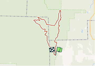
Randonnée Marche de 16,5 km à découvrir à Québec, Le Granit, Notre-Dame-des-Bois. Cette randonnée est proposée par Alizée.pee.
Description
Le sentier commence tout d’abord par l’ascension vers le mont Saint-Joseph qui vous amène vers une petite chapelle très mignonne. Ensuite, vous allez rejoindre le mont Victoria par le Sentier des Crêtes (avec un dénivelé assez faible). Le sommet du Mont Victoria est assez boisé. Ensuite, le sentier continue vers le sommet du Mont Mégantic sur lequel se trouve l’Observatoire astronomique, à visiter ! Lorsque le temps est de la partie, il est possible d’observer depuis le sommet du Mont Mégantic, le Mont Orford. Après une petite pause pour observer la magnifique vue qui s’offre à vous, il vous suffit de redescendre vers le point d’arrivée en suivant les indications.
Points d'intérêt
Localisation
Commentaires
Randonnées à proximité
![Randonnée Marche Notre-Dame-des-Bois - Parc national du Mont-Mégantic / Sentier du Mont-Saint-Joseph - Photo](https://media.geolcdn.com/t/375/260/ext.jpg?maxdim=2&url=https%3A%2F%2Fstatic1.geolcdn.com%2Fsiteimages%2Fupload%2Ffiles%2F1553511878bg_sport_marche.png)
![Marche Marche](https://static1.geolcdn.com/sitytour/trail-icons/101.png)
Marche
![](/images/other/stat-length.png)
![](https://static1.geolcdn.com/siteimages/upload/files/16400158638029165_repeat_loop_refresh_sync_direction_icon.png)
![Randonnée Marche Notre-Dame-des-Bois - Mont Saint-Joseph - Photo](https://media.geolcdn.com/t/375/260/ext.jpg?maxdim=2&url=https%3A%2F%2Fstatic1.geolcdn.com%2Fsiteimages%2Fupload%2Ffiles%2F1553511878bg_sport_marche.png)
![Marche Marche](https://static1.geolcdn.com/sitytour/trail-icons/101.png)
Marche
![](/images/other/stat-length.png)
![](https://static1.geolcdn.com/siteimages/upload/files/16400158638029165_repeat_loop_refresh_sync_direction_icon.png)
![Randonnée Trail Notre-Dame-des-Bois - mont saint Joseph - Photo](https://media.geolcdn.com/t/375/260/ext.jpg?maxdim=2&url=https%3A%2F%2Fstatic1.geolcdn.com%2Fsiteimages%2Fupload%2Ffiles%2F1524743154running.jpg)
![Trail Trail](https://static1.geolcdn.com/sitytour/trail-icons/104.png)
Trail
![](/images/other/stat-length.png)
![](https://static1.geolcdn.com/siteimages/upload/files/16400158638029165_repeat_loop_refresh_sync_direction_icon.png)