![](/images/other/stat-length.png)
![Randonnée Marche Unknown - Vallée du Paradis - Photo](https://media.geolcdn.com/t/1900/400/ext.pjpeg?maxdim=2&url=https%3A%2F%2Fstatic1.geolcdn.com%2Fsiteimages%2Fupload%2Ffiles%2F1553511878bg_sport_marche.png)
Vallée du Paradis
Alizée.pee
Utilisateur GUIDE
![Longueur](/images/other/stat-length.png)
Longueur
21 km
![Altitude max](https://static1.geolcdn.com/siteimages/upload/files/1508320355ic_sort_altitude_max_24dp.png)
Altitude max
2134 m
![Dénivelé positif](https://static1.geolcdn.com/siteimages/upload/files/1508320355ic_sort_den_pos_24dp.png)
Dénivelé positif
629 m
![Km-Effort](/images/other/stat-length.png)
Km-Effort
29 km
![Altitude min](https://static1.geolcdn.com/siteimages/upload/files/1508320355ic_sort_altitude_min_24dp.png)
Altitude min
1725 m
![Dénivelé négatif](https://static1.geolcdn.com/siteimages/upload/files/1508320355ic_sort_den_neg_24dp.png)
Dénivelé négatif
631 m
![Boucle](https://static1.geolcdn.com/siteimages/upload/files/16400158638029165_repeat_loop_refresh_sync_direction_icon.png)
Boucle
Oui
Date de création :
2019-08-26 12:53:54.811
Dernière modification :
2019-08-26 12:59:35.522
![Marche](https://static1.geolcdn.com/sitytour/trail-icons/101.png)
6h06
Difficulté : Très difficile
![Scannez ce code QR pour ouvrir la randonnée dans l'application SityTrail](https://capi.geolives.com/qq0zvz2zws4bq2lad0pu/sitytour/trails/2183590/qr.png?size=200)
Application GPS de randonnée GRATUITE
À propos
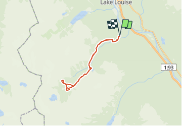
Randonnée Marche de 21 km à découvrir à Alberta, Improvement District No. 9. Cette randonnée est proposée par Alizée.pee.
Description
Randonnée assez longue mais avec des vues magnifiques ! Passages par des points d'eau, de jolies chutes d'eau et de beaux points de vue sur des montagnes et vallées.
Beaucoup de dénivelés mais très sympa !
Localisation
Pays :
Canada
Région :
Alberta
Département/Province :
Improvement District No. 9
Commune :
Unknown
Localité :
Unknown
Départ:(Dec)
Départ:(UTM)
557607 ; 5694197 (11U) N.
Commentaires
Randonnées à proximité
![Randonnée Marche - La plaine des 6 glaciers - Photo](https://media.geolcdn.com/t/375/260/ext.jpg?maxdim=2&url=https%3A%2F%2Fstatic1.geolcdn.com%2Fsiteimages%2Fupload%2Ffiles%2F1553511878bg_sport_marche.png)
![Marche Marche](https://static1.geolcdn.com/sitytour/trail-icons/101.png)
La plaine des 6 glaciers
Marche
Moyen
,
Alberta,
Improvement District No. 9,
Canada
![](/images/other/stat-length.png)
13,8 km | 21 km-effort
4h 17min
![](https://static1.geolcdn.com/siteimages/upload/files/16400158638029165_repeat_loop_refresh_sync_direction_icon.png)
Oui
![Randonnée Marche - Sentier du Lac Agnès - Photo](https://media.geolcdn.com/t/375/260/ext.jpg?maxdim=2&url=https%3A%2F%2Fstatic1.geolcdn.com%2Fsiteimages%2Fupload%2Ffiles%2F1553511878bg_sport_marche.png)
![Marche Marche](https://static1.geolcdn.com/sitytour/trail-icons/101.png)
Sentier du Lac Agnès
Marche
Difficile
,
Alberta,
Improvement District No. 9,
Canada
![](/images/other/stat-length.png)
12,4 km | 21 km-effort
4h 13min
![](https://static1.geolcdn.com/siteimages/upload/files/16400158638029165_repeat_loop_refresh_sync_direction_icon.png)
Oui
![Randonnée Marche - Lac Louise et Lac Agnès, Alberta - Photo](https://media.geolcdn.com/t/375/260/ext.jpg?maxdim=2&url=https%3A%2F%2Fstatic1.geolcdn.com%2Fsiteimages%2Fupload%2Ffiles%2F1553511878bg_sport_marche.png)
![Marche Marche](https://static1.geolcdn.com/sitytour/trail-icons/101.png)
Lac Louise et Lac Agnès, Alberta
Marche
Difficile
,
Alberta,
Improvement District No. 9,
Canada
![](/images/other/stat-length.png)
12,4 km | 21 km-effort
4h 13min
![](https://static1.geolcdn.com/siteimages/upload/files/16400158638029165_repeat_loop_refresh_sync_direction_icon.png)
Oui
![Randonnée Autre activité - Sentinel Pass - Photo](https://media.geolcdn.com/t/375/260/ext.jpg?maxdim=2&url=https%3A%2F%2Fstatic1.geolcdn.com%2Fsiteimages%2Fupload%2Ffiles%2F1545311037marcheuse_200dpi.jpg)
![Autre activité Autre activité](https://static1.geolcdn.com/sitytour/trail-icons/900.png)
Sentinel Pass
Autre activité
Très facile
,
Alberta,
Improvement District No. 9,
Canada
![](/images/other/stat-length.png)
15,1 km | 33 km-effort
Inconnu
![](https://static1.geolcdn.com/siteimages/upload/files/16400158638029165_repeat_loop_refresh_sync_direction_icon.png)
Non
![Randonnée Autre activité - Louise Lake - Photo](https://media.geolcdn.com/t/375/260/ext.jpg?maxdim=2&url=https%3A%2F%2Fstatic1.geolcdn.com%2Fsiteimages%2Fupload%2Ffiles%2F1545311037marcheuse_200dpi.jpg)
![Autre activité Autre activité](https://static1.geolcdn.com/sitytour/trail-icons/900.png)
Louise Lake
Autre activité
Très facile
,
Alberta,
Improvement District No. 9,
Canada
![](/images/other/stat-length.png)
8,1 km | 18,4 km-effort
Inconnu
![](https://static1.geolcdn.com/siteimages/upload/files/16400158638029165_repeat_loop_refresh_sync_direction_icon.png)
Non