![](/images/other/stat-length.png)
![Randonnée Marche Brewster Creek - Cory pass - Photo](https://media.geolcdn.com/t/1900/400/ext.pjpeg?maxdim=2&url=https%3A%2F%2Fstatic1.geolcdn.com%2Fsiteimages%2Fupload%2Ffiles%2F1553511878bg_sport_marche.png)
Cory pass
Alizée.pee
Utilisateur GUIDE
![Longueur](/images/other/stat-length.png)
Longueur
13,6 km
![Altitude max](https://static1.geolcdn.com/siteimages/upload/files/1508320355ic_sort_altitude_max_24dp.png)
Altitude max
2361 m
![Dénivelé positif](https://static1.geolcdn.com/siteimages/upload/files/1508320355ic_sort_den_pos_24dp.png)
Dénivelé positif
1057 m
![Km-Effort](/images/other/stat-length.png)
Km-Effort
28 km
![Altitude min](https://static1.geolcdn.com/siteimages/upload/files/1508320355ic_sort_altitude_min_24dp.png)
Altitude min
1389 m
![Dénivelé négatif](https://static1.geolcdn.com/siteimages/upload/files/1508320355ic_sort_den_neg_24dp.png)
Dénivelé négatif
1061 m
![Boucle](https://static1.geolcdn.com/siteimages/upload/files/16400158638029165_repeat_loop_refresh_sync_direction_icon.png)
Boucle
Oui
Date de création :
2019-08-26 11:37:49.317
Dernière modification :
2019-08-26 11:43:01.497
![Marche](https://static1.geolcdn.com/sitytour/trail-icons/101.png)
5h29
Difficulté : Très difficile
![Scannez ce code QR pour ouvrir la randonnée dans l'application SityTrail](https://capi.geolives.com/qq0zvz2zws4bq2lad0pu/sitytour/trails/2183497/qr.png?size=200)
Application GPS de randonnée GRATUITE
À propos
Randonnée Marche de 13,6 km à découvrir à Alberta, Improvement District No. 9. Cette randonnée est proposée par Alizée.pee.
Description
Randonnée sympa avec des vues magnifiques. Elle demande beaucoup d'efforts et de cardio mais ça en vaut la peine. Les vues sont déja splendides dès le début de la rando !
Localisation
Pays :
Canada
Région :
Alberta
Département/Province :
Improvement District No. 9
Commune :
Brewster Creek
Localité :
Unknown
Départ:(Dec)
Départ:(UTM)
593668 ; 5669682 (11U) N.
Commentaires
Randonnées à proximité
![Randonnée Marche - Johnston Canyon - Photo](https://media.geolcdn.com/t/375/260/ext.jpg?maxdim=2&url=https%3A%2F%2Fstatic1.geolcdn.com%2Fsiteimages%2Fupload%2Ffiles%2F1553511878bg_sport_marche.png)
![Marche Marche](https://static1.geolcdn.com/sitytour/trail-icons/101.png)
Johnston Canyon
Marche
Difficile
,
Alberta,
Improvement District No. 9,
Canada
![](/images/other/stat-length.png)
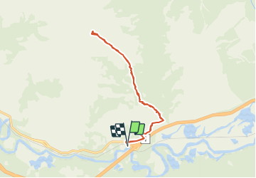
13,4 km | 20 km-effort
4h 10min
![](https://static1.geolcdn.com/siteimages/upload/files/16400158638029165_repeat_loop_refresh_sync_direction_icon.png)
Oui
![Randonnée Marche - Sentier Sulphur Mountain - Photo](https://media.geolcdn.com/t/375/260/ext.jpg?maxdim=2&url=https%3A%2F%2Fstatic1.geolcdn.com%2Fsiteimages%2Fupload%2Ffiles%2F1553511878bg_sport_marche.png)
![Marche Marche](https://static1.geolcdn.com/sitytour/trail-icons/101.png)
Sentier Sulphur Mountain
Marche
Très difficile
,
Alberta,
Improvement District No. 9,
Canada
![](/images/other/stat-length.png)
18,9 km | 31 km-effort
6h 26min
![](https://static1.geolcdn.com/siteimages/upload/files/16400158638029165_repeat_loop_refresh_sync_direction_icon.png)
Oui
![Randonnée Marche - Lac Minnewanka - Parc National de Banff - Photo](https://media.geolcdn.com/t/375/260/ext.jpg?maxdim=2&url=https%3A%2F%2Fstatic1.geolcdn.com%2Fsiteimages%2Fupload%2Ffiles%2F1553511878bg_sport_marche.png)
![Marche Marche](https://static1.geolcdn.com/sitytour/trail-icons/101.png)
Lac Minnewanka - Parc National de Banff
Marche
Moyen
,
Alberta,
Improvement District No. 9,
Canada
![](/images/other/stat-length.png)
6,4 km | 8 km-effort
1h 43min
![](https://static1.geolcdn.com/siteimages/upload/files/16400158638029165_repeat_loop_refresh_sync_direction_icon.png)
Oui
![Randonnée Autre activité - Castle-Mountain - Photo](https://media.geolcdn.com/t/375/260/ext.jpg?maxdim=2&url=https%3A%2F%2Fstatic1.geolcdn.com%2Fsiteimages%2Fupload%2Ffiles%2F1545311037marcheuse_200dpi.jpg)
![Autre activité Autre activité](https://static1.geolcdn.com/sitytour/trail-icons/900.png)
Castle-Mountain
Autre activité
Très facile
,
Alberta,
Improvement District No. 9,
Canada
![](/images/other/stat-length.png)
8,3 km | 16,3 km-effort
Inconnu
![](https://static1.geolcdn.com/siteimages/upload/files/16400158638029165_repeat_loop_refresh_sync_direction_icon.png)
Non
![Randonnée Autre activité - ata - Photo](https://media.geolcdn.com/t/375/260/ext.jpg?maxdim=2&url=https%3A%2F%2Fstatic1.geolcdn.com%2Fsiteimages%2Fupload%2Ffiles%2F1545311037marcheuse_200dpi.jpg)
![Autre activité Autre activité](https://static1.geolcdn.com/sitytour/trail-icons/900.png)