![](/images/other/stat-length.png)
![Randonnée Marche Lac-Pikauba - Sentier Le Pioui, Parc National des Grands-Jardins . - Photo](https://media.geolcdn.com/t/1900/400/ext.pjpeg?maxdim=2&url=https%3A%2F%2Fstatic1.geolcdn.com%2Fsiteimages%2Fupload%2Ffiles%2F1553511878bg_sport_marche.png)
Sentier Le Pioui, Parc National des Grands-Jardins .
Alizée.pee
Utilisateur GUIDE
![Longueur](/images/other/stat-length.png)
Longueur
10,8 km
![Altitude max](https://static1.geolcdn.com/siteimages/upload/files/1508320355ic_sort_altitude_max_24dp.png)
Altitude max
966 m
![Dénivelé positif](https://static1.geolcdn.com/siteimages/upload/files/1508320355ic_sort_den_pos_24dp.png)
Dénivelé positif
596 m
![Km-Effort](/images/other/stat-length.png)
Km-Effort
18,7 km
![Altitude min](https://static1.geolcdn.com/siteimages/upload/files/1508320355ic_sort_altitude_min_24dp.png)
Altitude min
526 m
![Dénivelé négatif](https://static1.geolcdn.com/siteimages/upload/files/1508320355ic_sort_den_neg_24dp.png)
Dénivelé négatif
598 m
![Boucle](https://static1.geolcdn.com/siteimages/upload/files/16400158638029165_repeat_loop_refresh_sync_direction_icon.png)
Boucle
Oui
Date de création :
2019-08-23 14:20:08.376
Dernière modification :
2019-08-23 14:21:41.663
![Marche](https://static1.geolcdn.com/sitytour/trail-icons/101.png)
3h48
Difficulté : Difficile
![Scannez ce code QR pour ouvrir la randonnée dans l'application SityTrail](https://capi.geolives.com/qq0zvz2zws4bq2lad0pu/sitytour/trails/2180433/qr.png?size=200)
Application GPS de randonnée GRATUITE
À propos
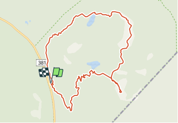
Randonnée Marche de 10,8 km à découvrir à Québec, Charlevoix, Lac-Pikauba. Cette randonnée est proposée par Alizée.pee.
Description
Cette randonnée est composée d'une ascension soutenue ainsi qu'un morceau sur les crêtes. Au sommet, il y a la présence d'une tourbière ainsi que de la végétation alpine.
Localisation
Pays :
Canada
Région :
Québec
Département/Province :
Charlevoix
Commune :
Lac-Pikauba
Localité :
Unknown
Départ:(Dec)
Départ:(UTM)
377793 ; 5280639 (19T) N.
Commentaires
Randonnées à proximité
![Randonnée Marche Lac-Pikauba - La Chouenne - Photo](https://media.geolcdn.com/t/375/260/ext.jpg?maxdim=2&url=https%3A%2F%2Fstatic1.geolcdn.com%2Fsiteimages%2Fupload%2Ffiles%2F1553511878bg_sport_marche.png)
![Marche Marche](https://static1.geolcdn.com/sitytour/trail-icons/101.png)
La Chouenne
Marche
Facile
(1)
Lac-Pikauba,
Québec,
Charlevoix,
Canada
![](/images/other/stat-length.png)
4,7 km | 7,6 km-effort
1h 33min
![](https://static1.geolcdn.com/siteimages/upload/files/16400158638029165_repeat_loop_refresh_sync_direction_icon.png)
Oui
![Randonnée Vélo Lac-Pikauba - Mont du lac a L'Empeche et Mont Dufour - Photo](https://media.geolcdn.com/t/375/260/ext.jpg?maxdim=2&url=https%3A%2F%2Fstatic1.geolcdn.com%2Fsiteimages%2Fupload%2Ffiles%2F1524743154velo.jpg)
![Vélo Vélo](https://static1.geolcdn.com/sitytour/trail-icons/200.png)
Mont du lac a L'Empeche et Mont Dufour
Vélo
Moyen
Lac-Pikauba,
Québec,
Charlevoix,
Canada
![](/images/other/stat-length.png)
13,1 km | 21 km-effort
2h 0min
![](https://static1.geolcdn.com/siteimages/upload/files/16400158638029165_repeat_loop_refresh_sync_direction_icon.png)
Oui
![Randonnée Marche Lac-Pikauba - Mont du Dôme, Zec des Martres - Photo](https://media.geolcdn.com/t/375/260/ext.jpg?maxdim=2&url=https%3A%2F%2Fstatic1.geolcdn.com%2Fsiteimages%2Fupload%2Ffiles%2F1553511878bg_sport_marche.png)
![Marche Marche](https://static1.geolcdn.com/sitytour/trail-icons/101.png)
Mont du Dôme, Zec des Martres
Marche
Facile
Lac-Pikauba,
Québec,
Charlevoix,
Canada
![](/images/other/stat-length.png)
7,7 km | 13,1 km-effort
3h 30min
![](https://static1.geolcdn.com/siteimages/upload/files/16400158638029165_repeat_loop_refresh_sync_direction_icon.png)
Oui
![Randonnée Marche Lac-Pikauba - Le Mont du Lac à l'Empêche et Du Four - Photo](https://media.geolcdn.com/t/375/260/ext.jpg?maxdim=2&url=https%3A%2F%2Fstatic1.geolcdn.com%2Fsiteimages%2Fupload%2Ffiles%2F1553511878bg_sport_marche.png)
![Marche Marche](https://static1.geolcdn.com/sitytour/trail-icons/101.png)
Le Mont du Lac à l'Empêche et Du Four
Marche
Moyen
(1)
Lac-Pikauba,
Québec,
Charlevoix,
Canada
![](/images/other/stat-length.png)
13,5 km | 22 km-effort
6h 0min
![](https://static1.geolcdn.com/siteimages/upload/files/16400158638029165_repeat_loop_refresh_sync_direction_icon.png)
Oui
![Randonnée Marche Lac-Pikauba - Mont de l'Ours et Mont du Lac des Cygnes - Photo](https://media.geolcdn.com/t/375/260/ext.jpg?maxdim=2&url=https%3A%2F%2Fstatic1.geolcdn.com%2Fsiteimages%2Fupload%2Ffiles%2F1553511878bg_sport_marche.png)
![Marche Marche](https://static1.geolcdn.com/sitytour/trail-icons/101.png)
Mont de l'Ours et Mont du Lac des Cygnes
Marche
Moyen
Lac-Pikauba,
Québec,
Charlevoix,
Canada
![](/images/other/stat-length.png)
11,4 km | 19,4 km-effort
5h 0min
![](https://static1.geolcdn.com/siteimages/upload/files/16400158638029165_repeat_loop_refresh_sync_direction_icon.png)
Oui
![Randonnée Marche Lac-Pikauba - Sentier la Chouenne - Parc national des Grands-Jardins - Photo](https://media.geolcdn.com/t/375/260/ext.jpg?maxdim=2&url=https%3A%2F%2Fstatic1.geolcdn.com%2Fsiteimages%2Fupload%2Ffiles%2F1553511878bg_sport_marche.png)
![Marche Marche](https://static1.geolcdn.com/sitytour/trail-icons/101.png)
Sentier la Chouenne - Parc national des Grands-Jardins
Marche
Moyen
(1)
Lac-Pikauba,
Québec,
Charlevoix,
Canada
![](/images/other/stat-length.png)
4,6 km | 7,5 km-effort
1h 32min
![](https://static1.geolcdn.com/siteimages/upload/files/16400158638029165_repeat_loop_refresh_sync_direction_icon.png)
Oui
![Randonnée Marche Lac-Pikauba - Le mont du lac des cygnes - Photo](https://media.geolcdn.com/t/375/260/ext.jpg?maxdim=2&url=https%3A%2F%2Fstatic1.geolcdn.com%2Fsiteimages%2Fupload%2Ffiles%2F1553511878bg_sport_marche.png)
![Marche Marche](https://static1.geolcdn.com/sitytour/trail-icons/101.png)
Le mont du lac des cygnes
Marche
Moyen
Lac-Pikauba,
Québec,
Charlevoix,
Canada
![](/images/other/stat-length.png)
4 km | 8,2 km-effort
1h 55min
![](https://static1.geolcdn.com/siteimages/upload/files/16400158638029165_repeat_loop_refresh_sync_direction_icon.png)
Non
![Randonnée Marche Lac-Pikauba - mont du lac des cygnes - Photo](https://media.geolcdn.com/t/375/260/ext.jpg?maxdim=2&url=https%3A%2F%2Fstatic1.geolcdn.com%2Fsiteimages%2Fupload%2Ffiles%2F1553511878bg_sport_marche.png)
![Marche Marche](https://static1.geolcdn.com/sitytour/trail-icons/101.png)
mont du lac des cygnes
Marche
Moyen
Lac-Pikauba,
Québec,
Charlevoix,
Canada
![](/images/other/stat-length.png)
12,1 km | 20 km-effort
5h 8min
![](https://static1.geolcdn.com/siteimages/upload/files/16400158638029165_repeat_loop_refresh_sync_direction_icon.png)
Oui