![](/images/other/stat-length.png)
![Randonnée Marche Névache - RA 2019 Tour Mont Thabor J4 - Photo](https://media.geolcdn.com/t/1900/400/232381b5-1925-4c46-98a1-99d524da3daf.jpg&format=pjpeg&maxdim=2)
RA 2019 Tour Mont Thabor J4
dfluzin
Utilisateur
![Longueur](/images/other/stat-length.png)
![Altitude max](https://static1.geolcdn.com/siteimages/upload/files/1508320355ic_sort_altitude_max_24dp.png)
![Dénivelé positif](https://static1.geolcdn.com/siteimages/upload/files/1508320355ic_sort_den_pos_24dp.png)
![Km-Effort](/images/other/stat-length.png)
![Altitude min](https://static1.geolcdn.com/siteimages/upload/files/1508320355ic_sort_altitude_min_24dp.png)
![Dénivelé négatif](https://static1.geolcdn.com/siteimages/upload/files/1508320355ic_sort_den_neg_24dp.png)
![Boucle](https://static1.geolcdn.com/siteimages/upload/files/16400158638029165_repeat_loop_refresh_sync_direction_icon.png)
![Marche](https://static1.geolcdn.com/sitytour/trail-icons/101.png)
6h53
Difficulté : Difficile
![Scannez ce code QR pour ouvrir la randonnée dans l'application SityTrail](https://capi.geolives.com/qq0zvz2zws4bq2lad0pu/sitytour/trails/2180187/qr.png?size=200)
Application GPS de randonnée GRATUITE
À propos
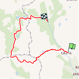
Randonnée Marche de 16,1 km à découvrir à Provence-Alpes-Côte d'Azur, Hautes-Alpes, Névache. Cette randonnée est proposée par dfluzin.
Description
Nous continuons notre périple par l'incontournable Tour des Cerces où la féerie des lacs bat son plein. En partant du refuge de Laval, nous sommes presque de suite dans la partie la plus physique de la journée avec la montée d'un trait au col des Béraudes. Bien sûr le lac des Béraudes vaut à lui seul la montée, mais les autres à venir sont autant de joyaux. Tour très varié dans ses paysages, et une fois le col des Béraudes passé (préférez de loin le temps sec) le parcours permet d'apprécier. Nous rejoignons le lac source de la Clarée et la descente vers les Drayères d'effectue sans aucune difficulté
Localisation
Commentaires
Randonnées à proximité
![Randonnée Marche Névache - Névache - l'Argentière Lac Laramon Lac du Serpent - 10km 600m 3h10 (30mn) - 2014 06 01 - Photo](https://media.geolcdn.com/t/375/260/ext.jpg?maxdim=2&url=https%3A%2F%2Fservices.sitytrail.com%2FGeolivesWS%2FDownloadMedia.ashx%3FTrailID%3D308075%26Media%3Dfix__20140601111157.jpg)
![Marche Marche](https://static1.geolcdn.com/sitytour/trail-icons/101.png)
Marche
![](/images/other/stat-length.png)
![](https://static1.geolcdn.com/siteimages/upload/files/16400158638029165_repeat_loop_refresh_sync_direction_icon.png)
![Randonnée Marche Névache - Col du Chardonnet - Névache - Photo](https://media.geolcdn.com/t/375/260/ext.jpg?maxdim=2&url=https%3A%2F%2Fservices.sitytrail.com%2FGeolivesWS%2FDownloadMedia.ashx%3FTrailID%3D172510%26Media%3D13871_4.jpg)
![Marche Marche](https://static1.geolcdn.com/sitytour/trail-icons/101.png)
Marche
![](/images/other/stat-length.png)
![](https://static1.geolcdn.com/siteimages/upload/files/16400158638029165_repeat_loop_refresh_sync_direction_icon.png)
![Randonnée Marche Névache - Beraudes - Photo](https://media.geolcdn.com/t/375/260/0b2aacf4-b966-4747-8342-45afac1d45d3.jpg&format=jpg&maxdim=2)
![Marche Marche](https://static1.geolcdn.com/sitytour/trail-icons/101.png)
Marche
![](/images/other/stat-length.png)
![](https://static1.geolcdn.com/siteimages/upload/files/16400158638029165_repeat_loop_refresh_sync_direction_icon.png)
![Randonnée Marche Névache - Col de Buffère - Photo](https://media.geolcdn.com/t/375/260/29173095-8bad-4703-9f92-e4d79283feeb.jpg&format=jpg&maxdim=2)
![Marche Marche](https://static1.geolcdn.com/sitytour/trail-icons/101.png)
Marche
![](/images/other/stat-length.png)
![](https://static1.geolcdn.com/siteimages/upload/files/16400158638029165_repeat_loop_refresh_sync_direction_icon.png)
![Randonnée Marche Névache - Col roche noire - Photo](https://media.geolcdn.com/t/375/260/677a67a8-134f-4e40-9c36-524ac13be98e.jpg&format=jpg&maxdim=2)
![Marche Marche](https://static1.geolcdn.com/sitytour/trail-icons/101.png)
Marche
![](/images/other/stat-length.png)
![](https://static1.geolcdn.com/siteimages/upload/files/16400158638029165_repeat_loop_refresh_sync_direction_icon.png)
![Randonnée Via ferrata Le Monêtier-les-Bains - Via ferrata Aiguillette du Lauzet - Photo](https://media.geolcdn.com/t/375/260/f94c7ee2-184f-466f-9471-9131d6d51143.jpg&format=jpg&maxdim=2)
![Via ferrata Via ferrata](https://static1.geolcdn.com/sitytour/trail-icons/902.png)
Via ferrata
![](/images/other/stat-length.png)
![](https://static1.geolcdn.com/siteimages/upload/files/16400158638029165_repeat_loop_refresh_sync_direction_icon.png)
![Randonnée Marche Névache - la roche du Chardonnet - Photo](https://media.geolcdn.com/t/375/260/ext.jpg?maxdim=2&url=https%3A%2F%2Fservices.sitytrail.com%2FGeolivesWS%2FDownloadMedia.ashx%3FTrailID%3D1011228%26Media%3Dfix__20180726084936.jpg)
![Marche Marche](https://static1.geolcdn.com/sitytour/trail-icons/101.png)
Marche
![](/images/other/stat-length.png)
![](https://static1.geolcdn.com/siteimages/upload/files/16400158638029165_repeat_loop_refresh_sync_direction_icon.png)
![Randonnée Marche Névache - Lacs Laramon et Serpent - Photo](https://media.geolcdn.com/t/375/260/ext.jpg?maxdim=2&url=https%3A%2F%2Fstatic1.geolcdn.com%2Fsiteimages%2Fupload%2Ffiles%2F1553511878bg_sport_marche.png)
![Marche Marche](https://static1.geolcdn.com/sitytour/trail-icons/101.png)
Marche
![](/images/other/stat-length.png)
![](https://static1.geolcdn.com/siteimages/upload/files/16400158638029165_repeat_loop_refresh_sync_direction_icon.png)
![Randonnée Autre activité Névache - Pointe des Cerces . Circuit du lac rouge - Photo](https://media.geolcdn.com/t/375/260/ext.jpg?maxdim=2&url=https%3A%2F%2Fservices.sitytrail.com%2FGeolivesWS%2FDownloadMedia.ashx%3FTrailID%3D580876%26Media%3Dfix__20160518102430.jpg)
![Autre activité Autre activité](https://static1.geolcdn.com/sitytour/trail-icons/900.png)
Autre activité
![](/images/other/stat-length.png)
![](https://static1.geolcdn.com/siteimages/upload/files/16400158638029165_repeat_loop_refresh_sync_direction_icon.png)