![](/images/other/stat-length.png)
![Randonnée Marche Mont-Albert - Mont xalibu - Photo](https://media.geolcdn.com/t/1900/400/ext.pjpeg?maxdim=2&url=https%3A%2F%2Fstatic1.geolcdn.com%2Fsiteimages%2Fupload%2Ffiles%2F1553511878bg_sport_marche.png)
Mont xalibu
Alizée.pee
Utilisateur GUIDE
![Longueur](/images/other/stat-length.png)
Longueur
12,3 km
![Altitude max](https://static1.geolcdn.com/siteimages/upload/files/1508320355ic_sort_altitude_max_24dp.png)
Altitude max
1135 m
![Dénivelé positif](https://static1.geolcdn.com/siteimages/upload/files/1508320355ic_sort_den_pos_24dp.png)
Dénivelé positif
573 m
![Km-Effort](/images/other/stat-length.png)
Km-Effort
19,9 km
![Altitude min](https://static1.geolcdn.com/siteimages/upload/files/1508320355ic_sort_altitude_min_24dp.png)
Altitude min
600 m
![Dénivelé négatif](https://static1.geolcdn.com/siteimages/upload/files/1508320355ic_sort_den_neg_24dp.png)
Dénivelé négatif
573 m
![Boucle](https://static1.geolcdn.com/siteimages/upload/files/16400158638029165_repeat_loop_refresh_sync_direction_icon.png)
Boucle
Oui
Date de création :
2019-08-22 12:32:39.04
Dernière modification :
2019-08-22 12:34:57.47
![Marche](https://static1.geolcdn.com/sitytour/trail-icons/101.png)
4h05
Difficulté : Difficile
![Scannez ce code QR pour ouvrir la randonnée dans l'application SityTrail](https://capi.geolives.com/qq0zvz2zws4bq2lad0pu/sitytour/trails/2179177/qr.png?size=200)
Application GPS de randonnée GRATUITE
À propos
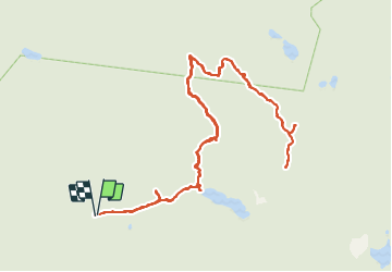
Randonnée Marche de 12,3 km à découvrir à Québec, La Haute-Gaspésie, Mont-Albert. Cette randonnée est proposée par Alizée.pee.
Description
Situé dans le parc national de la Gaspésie, le Mont-Xalibu est un des plus hauts sommets des monts Notre-Dame. La randonnée offre une magnifique vue d'un lac. L'ascension n'est pas des plus simples mais elle en vaut la peine !
Localisation
Pays :
Canada
Région :
Québec
Département/Province :
La Haute-Gaspésie
Commune :
Mont-Albert
Localité :
Unknown
Départ:(Dec)
Départ:(UTM)
716479 ; 5426637 (19U) N.
Commentaires
Randonnées à proximité
![Randonnée Marche Mont-Albert - Mont Ernest-Laforce - Photo](https://media.geolcdn.com/t/375/260/ext.jpg?maxdim=2&url=https%3A%2F%2Fstatic1.geolcdn.com%2Fsiteimages%2Fupload%2Ffiles%2F1553511878bg_sport_marche.png)
![Marche Marche](https://static1.geolcdn.com/sitytour/trail-icons/101.png)
Mont Ernest-Laforce
Marche
Facile
(1)
Mont-Albert,
Québec,
La Haute-Gaspésie,
Canada
![](/images/other/stat-length.png)
4,5 km | 7 km-effort
1h 50min
![](https://static1.geolcdn.com/siteimages/upload/files/16400158638029165_repeat_loop_refresh_sync_direction_icon.png)
Oui
![Randonnée Marche Mont-Albert - Parc National de la Gaspésie - Sentier du Mont Richardson - Photo](https://media.geolcdn.com/t/375/260/ext.jpg?maxdim=2&url=https%3A%2F%2Fstatic1.geolcdn.com%2Fsiteimages%2Fupload%2Ffiles%2F1553511878bg_sport_marche.png)
![Marche Marche](https://static1.geolcdn.com/sitytour/trail-icons/101.png)
Parc National de la Gaspésie - Sentier du Mont Richardson
Marche
Très difficile
Mont-Albert,
Québec,
La Haute-Gaspésie,
Canada
![](/images/other/stat-length.png)
11,6 km | 22 km-effort
4h 26min
![](https://static1.geolcdn.com/siteimages/upload/files/16400158638029165_repeat_loop_refresh_sync_direction_icon.png)
Oui
![Randonnée Marche Mont-Albert - Parc National de la Gaspésie - Mont Ernest Laforce - Photo](https://media.geolcdn.com/t/375/260/ext.jpg?maxdim=2&url=https%3A%2F%2Fstatic1.geolcdn.com%2Fsiteimages%2Fupload%2Ffiles%2F1553511878bg_sport_marche.png)
![Marche Marche](https://static1.geolcdn.com/sitytour/trail-icons/101.png)
Parc National de la Gaspésie - Mont Ernest Laforce
Marche
Moyen
Mont-Albert,
Québec,
La Haute-Gaspésie,
Canada
![](/images/other/stat-length.png)
5,5 km | 8,6 km-effort
1h 46min
![](https://static1.geolcdn.com/siteimages/upload/files/16400158638029165_repeat_loop_refresh_sync_direction_icon.png)
Oui
![Randonnée Marche Mont-Albert - Tour du mont Ernest Laforce - Photo](https://media.geolcdn.com/t/375/260/ext.jpg?maxdim=2&url=https%3A%2F%2Fstatic1.geolcdn.com%2Fsiteimages%2Fupload%2Ffiles%2F1553511878bg_sport_marche.png)
![Marche Marche](https://static1.geolcdn.com/sitytour/trail-icons/101.png)
Tour du mont Ernest Laforce
Marche
Très facile
Mont-Albert,
Québec,
La Haute-Gaspésie,
Canada
![](/images/other/stat-length.png)
7,8 km | 11,1 km-effort
1h 15min
![](https://static1.geolcdn.com/siteimages/upload/files/16400158638029165_repeat_loop_refresh_sync_direction_icon.png)
Non
![Randonnée Marche Mont-Albert - mont xalibu - Gaspésie - Photo](https://media.geolcdn.com/t/375/260/ext.jpg?maxdim=2&url=https%3A%2F%2Fstatic1.geolcdn.com%2Fsiteimages%2Fupload%2Ffiles%2F1553511878bg_sport_marche.png)
![Marche Marche](https://static1.geolcdn.com/sitytour/trail-icons/101.png)
mont xalibu - Gaspésie
Marche
Moyen
Mont-Albert,
Québec,
La Haute-Gaspésie,
Canada
![](/images/other/stat-length.png)
11,3 km | 18,6 km-effort
2h 51min
![](https://static1.geolcdn.com/siteimages/upload/files/16400158638029165_repeat_loop_refresh_sync_direction_icon.png)
Non
![Randonnée Marche Mont-Albert - mont Ernest Laforce - Photo](https://media.geolcdn.com/t/375/260/ext.jpg?maxdim=2&url=https%3A%2F%2Fstatic1.geolcdn.com%2Fsiteimages%2Fupload%2Ffiles%2F1553511878bg_sport_marche.png)
![Marche Marche](https://static1.geolcdn.com/sitytour/trail-icons/101.png)
mont Ernest Laforce
Marche
Facile
Mont-Albert,
Québec,
La Haute-Gaspésie,
Canada
![](/images/other/stat-length.png)
4,8 km | 7,3 km-effort
1h 30min
![](https://static1.geolcdn.com/siteimages/upload/files/16400158638029165_repeat_loop_refresh_sync_direction_icon.png)
Oui
![Randonnée Marche Mont-Albert - mont ernest laforce - Photo](https://media.geolcdn.com/t/375/260/ext.jpg?maxdim=2&url=https%3A%2F%2Fstatic1.geolcdn.com%2Fsiteimages%2Fupload%2Ffiles%2F1553511878bg_sport_marche.png)
![Marche Marche](https://static1.geolcdn.com/sitytour/trail-icons/101.png)
mont ernest laforce
Marche
Facile
Mont-Albert,
Québec,
La Haute-Gaspésie,
Canada
![](/images/other/stat-length.png)
4,7 km | 7,1 km-effort
1h 46min
![](https://static1.geolcdn.com/siteimages/upload/files/16400158638029165_repeat_loop_refresh_sync_direction_icon.png)
Oui
![Randonnée Marche Mont-Albert - Mt Ernest Laforce (Parc de Gaspésie) 5 sept 2018 - Photo](https://media.geolcdn.com/t/375/260/ext.jpg?maxdim=2&url=https%3A%2F%2Fstatic1.geolcdn.com%2Fsiteimages%2Fupload%2Ffiles%2F1553511878bg_sport_marche.png)
![Marche Marche](https://static1.geolcdn.com/sitytour/trail-icons/101.png)
Mt Ernest Laforce (Parc de Gaspésie) 5 sept 2018
Marche
Facile
Mont-Albert,
Québec,
La Haute-Gaspésie,
Canada
![](/images/other/stat-length.png)
5 km | 7,5 km-effort
1h 33min
![](https://static1.geolcdn.com/siteimages/upload/files/16400158638029165_repeat_loop_refresh_sync_direction_icon.png)
Oui
![Randonnée Marche Mont-Albert - CANADA PARK GASPESIE Mont Ernest LAFORCE_2018_10_02 - Photo](https://media.geolcdn.com/t/375/260/ext.jpg?maxdim=2&url=https%3A%2F%2Fstatic1.geolcdn.com%2Fsiteimages%2Fupload%2Ffiles%2F1553511878bg_sport_marche.png)
![Marche Marche](https://static1.geolcdn.com/sitytour/trail-icons/101.png)
CANADA PARK GASPESIE Mont Ernest LAFORCE_2018_10_02
Marche
Très facile
Mont-Albert,
Québec,
La Haute-Gaspésie,
Canada
![](/images/other/stat-length.png)
4,3 km | 6,8 km-effort
Inconnu
![](https://static1.geolcdn.com/siteimages/upload/files/16400158638029165_repeat_loop_refresh_sync_direction_icon.png)
Oui