![](/images/other/stat-length.png)
![Randonnée Cyclotourisme La Haye - NL.Voorburg.64.361VTC - Photo](https://media.geolcdn.com/t/1900/400/ext.pjpeg?maxdim=2&url=https%3A%2F%2Fstatic1.geolcdn.com%2Fsiteimages%2Fupload%2Ffiles%2F1524743154velo.jpg)
NL.Voorburg.64.361VTC
francois58
Utilisateur
![Longueur](/images/other/stat-length.png)
![Altitude max](https://static1.geolcdn.com/siteimages/upload/files/1508320355ic_sort_altitude_max_24dp.png)
![Dénivelé positif](https://static1.geolcdn.com/siteimages/upload/files/1508320355ic_sort_den_pos_24dp.png)
![Km-Effort](/images/other/stat-length.png)
![Altitude min](https://static1.geolcdn.com/siteimages/upload/files/1508320355ic_sort_altitude_min_24dp.png)
![Dénivelé négatif](https://static1.geolcdn.com/siteimages/upload/files/1508320355ic_sort_den_neg_24dp.png)
![Boucle](https://static1.geolcdn.com/siteimages/upload/files/16400158638029165_repeat_loop_refresh_sync_direction_icon.png)
![Cyclotourisme](https://static1.geolcdn.com/sitytour/trail-icons/204.png)
--
Difficulté : Très facile
![Scannez ce code QR pour ouvrir la randonnée dans l'application SityTrail](https://capi.geolives.com/qq0zvz2zws4bq2lad0pu/sitytour/trails/2179025/qr.png?size=200)
Application GPS de randonnée GRATUITE
À propos
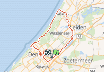
Randonnée Cyclotourisme de 64 km à découvrir à Hollande-Méridionale, Inconnu, La Haye. Cette randonnée est proposée par francois58.
Description
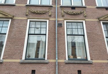
Belle sortie alliant de la randonnée vélo à une flânerie découverte de "Den Haag".
Tracé : 64km praticable en city bike et vélo route
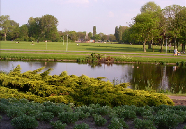
Intérêt : randonnée variée sur des chemins de halage, dans les dunes de bord de mer, sur les digues de Schevelingen et de Catwijk, un passage en forêt et une découverte culturelle et architecturale de "Den Haag".
Attention : à certains endroits (visite de Den Haag), il est demandé aux cyclistes de mettre pied à terre. En outre, il pourrait subsister de courts passages à contresens sur piste cyclable. Soyez vigilants.
Points d'intérêt
Localisation
Commentaires
Randonnées à proximité
![Randonnée Vélo Ryswick - Fietsroute in Den Haag - Photo](https://media.geolcdn.com/t/375/260/ext.jpg?maxdim=2&url=https%3A%2F%2Fservices.sitytrail.com%2FGeolivesWS%2FDownloadMedia.ashx%3FTrailID%3D112924%26Media%3Dc8fe9f09-7d23-4c32-8cc8-f12dff499768.png)
![Vélo Vélo](https://static1.geolcdn.com/sitytour/trail-icons/200.png)
Vélo
![](/images/other/stat-length.png)
![](https://static1.geolcdn.com/siteimages/upload/files/16400158638029165_repeat_loop_refresh_sync_direction_icon.png)
![Randonnée A pied La Haye - NS-wandeling Meijendel - Photo](https://media.geolcdn.com/t/375/260/6c24e446-94f5-490a-afd2-d15b11b6a22d.jpeg&format=jpg&maxdim=2)
![A pied A pied](https://static1.geolcdn.com/sitytour/trail-icons/100.png)
A pied
![](/images/other/stat-length.png)
![](https://static1.geolcdn.com/siteimages/upload/files/16400158638029165_repeat_loop_refresh_sync_direction_icon.png)
![Randonnée Marche La Haye - Zuid-Holland - Waalsdorpervlakte Meyendel en strand - Photo](https://media.geolcdn.com/t/375/260/ext.jpg?maxdim=2&url=https%3A%2F%2Fstatic1.geolcdn.com%2Fsiteimages%2Fupload%2Ffiles%2F1553511878bg_sport_marche.png)
![Marche Marche](https://static1.geolcdn.com/sitytour/trail-icons/101.png)
Marche
![](/images/other/stat-length.png)
![](https://static1.geolcdn.com/siteimages/upload/files/16400158638029165_repeat_loop_refresh_sync_direction_icon.png)
![Randonnée A pied La Haye - Monumentale bomen- en hofjesroute - Photo](https://media.geolcdn.com/t/375/260/c9449f43-f06d-4b0b-affa-2929ab655377.jpeg&format=jpg&maxdim=2)
![A pied A pied](https://static1.geolcdn.com/sitytour/trail-icons/100.png)
A pied
![](/images/other/stat-length.png)
![](https://static1.geolcdn.com/siteimages/upload/files/16400158638029165_repeat_loop_refresh_sync_direction_icon.png)
![Randonnée A pied La Haye - Groen met historie - Photo](https://media.geolcdn.com/t/375/260/5bc20cb0-b310-454a-ac19-ad713442ed35.jpeg&format=jpg&maxdim=2)
![A pied A pied](https://static1.geolcdn.com/sitytour/trail-icons/100.png)
A pied
![](/images/other/stat-length.png)
![](https://static1.geolcdn.com/siteimages/upload/files/16400158638029165_repeat_loop_refresh_sync_direction_icon.png)
![Randonnée A pied Leidschendam-Voorburg - Blauwe wandelroute - Photo](https://media.geolcdn.com/t/375/260/680fe59a-60e7-42ce-95ae-a286862edcea.jpeg&format=jpg&maxdim=2)
![A pied A pied](https://static1.geolcdn.com/sitytour/trail-icons/100.png)
A pied
![](/images/other/stat-length.png)
![](https://static1.geolcdn.com/siteimages/upload/files/16400158638029165_repeat_loop_refresh_sync_direction_icon.png)
![Randonnée A pied Leidschendam-Voorburg - Rode wandelroute - Photo](https://media.geolcdn.com/t/375/260/9edb32ad-de04-433b-8aee-b42e43e99df0.jpeg&format=jpg&maxdim=2)
![A pied A pied](https://static1.geolcdn.com/sitytour/trail-icons/100.png)
A pied
![](/images/other/stat-length.png)
![](https://static1.geolcdn.com/siteimages/upload/files/16400158638029165_repeat_loop_refresh_sync_direction_icon.png)
![Randonnée A pied Leidschendam-Voorburg - Oranje wandelroute - Photo](https://media.geolcdn.com/t/375/260/f1d3c9fc-acd1-4e59-b539-1c83ec2ee283.jpeg&format=jpg&maxdim=2)
![A pied A pied](https://static1.geolcdn.com/sitytour/trail-icons/100.png)
A pied
![](/images/other/stat-length.png)
![](https://static1.geolcdn.com/siteimages/upload/files/16400158638029165_repeat_loop_refresh_sync_direction_icon.png)
![Randonnée A pied Wassenaar - Gele wandelroute Clingendael - Photo](https://media.geolcdn.com/t/375/260/0aab8b00-b6d9-4d29-ba30-e423f1436156.jpeg&format=jpg&maxdim=2)
![A pied A pied](https://static1.geolcdn.com/sitytour/trail-icons/100.png)
A pied
![](/images/other/stat-length.png)
![](https://static1.geolcdn.com/siteimages/upload/files/16400158638029165_repeat_loop_refresh_sync_direction_icon.png)