![](/images/other/stat-length.png)
Chateau Thierry à Vélo 2
Bntg
Utilisateur
![Longueur](/images/other/stat-length.png)
![Altitude max](https://static1.geolcdn.com/siteimages/upload/files/1508320355ic_sort_altitude_max_24dp.png)
![Dénivelé positif](https://static1.geolcdn.com/siteimages/upload/files/1508320355ic_sort_den_pos_24dp.png)
![Km-Effort](/images/other/stat-length.png)
![Altitude min](https://static1.geolcdn.com/siteimages/upload/files/1508320355ic_sort_altitude_min_24dp.png)
![Dénivelé négatif](https://static1.geolcdn.com/siteimages/upload/files/1508320355ic_sort_den_neg_24dp.png)
![Boucle](https://static1.geolcdn.com/siteimages/upload/files/16400158638029165_repeat_loop_refresh_sync_direction_icon.png)
![V.T.C.](https://static1.geolcdn.com/sitytour/trail-icons/203.png)
--
Difficulté : Très facile
![Scannez ce code QR pour ouvrir la randonnée dans l'application SityTrail](https://capi.geolives.com/qq0zvz2zws4bq2lad0pu/sitytour/trails/2176084/qr.png?size=200)
Application GPS de randonnée GRATUITE
À propos
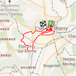
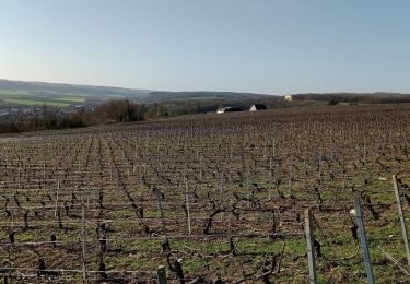
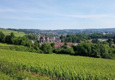
Randonnée V.T.C. de 13,4 km à découvrir à Hauts-de-France, Aisne, Château-Thierry. Cette randonnée est proposée par Bntg.
Description
Parcours conçu à partir de la carte et des points à voir listés sur le net.
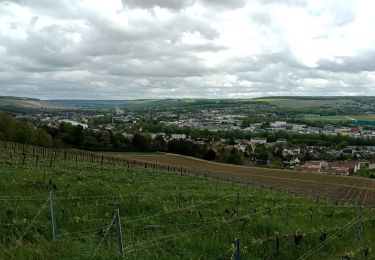
Attention entre km 1 et km 2, très difficile et partiellement impraticable en VTC et vélo de ville. La redescente par les vignes est agréable à la vue mais également réservée aux VTTistes. Le reste du parcours est fort agréable.
Localisation
Commentaires
Randonnées à proximité
![Randonnée Marche Château-Thierry - Château-Thierry du 20-10-2024 - Photo](https://media.geolcdn.com/t/375/260/01f4364c-7132-4755-84cb-ad0105634b93.jpg&format=jpg&maxdim=2)
![Marche Marche](https://static1.geolcdn.com/sitytour/trail-icons/101.png)
Marche
![](/images/other/stat-length.png)
![](https://static1.geolcdn.com/siteimages/upload/files/16400158638029165_repeat_loop_refresh_sync_direction_icon.png)
![Randonnée Marche Château-Thierry - Le chemin de St Colomban en IDF Etape 1 Chateau Thierry - Nanteuil sur Marne - Photo](https://media.geolcdn.com/t/375/260/9609d3ad-ab5e-4f8f-9f67-aa273e117c14.jpg&format=jpg&maxdim=2)
![Marche Marche](https://static1.geolcdn.com/sitytour/trail-icons/101.png)
Marche
![](/images/other/stat-length.png)
![](https://static1.geolcdn.com/siteimages/upload/files/16400158638029165_repeat_loop_refresh_sync_direction_icon.png)
![Randonnée Marche Château-Thierry - Les Vignes Castelles trace du 28-04-2024 - Photo](https://media.geolcdn.com/t/375/260/4b525fce-e0c7-44a3-ac4d-c251652c2d56.jpg&format=jpg&maxdim=2)
![Marche Marche](https://static1.geolcdn.com/sitytour/trail-icons/101.png)
Marche
![](/images/other/stat-length.png)
![](https://static1.geolcdn.com/siteimages/upload/files/16400158638029165_repeat_loop_refresh_sync_direction_icon.png)
![Randonnée Marche Château-Thierry - Les vignes Castelles - version 8 km - Photo](https://media.geolcdn.com/t/375/260/02397956-c095-41df-bc0b-2c08db7076aa.jpg&format=jpg&maxdim=2)
![Marche Marche](https://static1.geolcdn.com/sitytour/trail-icons/101.png)
Marche
![](/images/other/stat-length.png)
![](https://static1.geolcdn.com/siteimages/upload/files/16400158638029165_repeat_loop_refresh_sync_direction_icon.png)
![Randonnée Marche Chierry - Chierry - Photo](https://media.geolcdn.com/t/375/260/ext.jpg?maxdim=2&url=https%3A%2F%2Fstatic1.geolcdn.com%2Fsiteimages%2Fupload%2Ffiles%2F1553511878bg_sport_marche.png)
![Marche Marche](https://static1.geolcdn.com/sitytour/trail-icons/101.png)
Marche
![](/images/other/stat-length.png)
![](https://static1.geolcdn.com/siteimages/upload/files/16400158638029165_repeat_loop_refresh_sync_direction_icon.png)
![Randonnée Marche Nesles-la-Montagne - Nesles la Montagne du 02/06/2020 - Photo](https://media.geolcdn.com/t/375/260/e9e49450-fac4-4ee3-aafc-a88d23d73e0c.jpg&format=jpg&maxdim=2)
![Marche Marche](https://static1.geolcdn.com/sitytour/trail-icons/101.png)
Marche
![](/images/other/stat-length.png)
![](https://static1.geolcdn.com/siteimages/upload/files/16400158638029165_repeat_loop_refresh_sync_direction_icon.png)
![Randonnée V.T.T. Château-Thierry - Château / Mont St Père / Azy / Château - Photo](https://media.geolcdn.com/t/375/260/faaee0cb-6e62-4da4-afa4-df40725828c1.jpg&format=jpg&maxdim=2)
![V.T.T. V.T.T.](https://static1.geolcdn.com/sitytour/trail-icons/202.png)
V.T.T.
![](/images/other/stat-length.png)
![](https://static1.geolcdn.com/siteimages/upload/files/16400158638029165_repeat_loop_refresh_sync_direction_icon.png)
![Randonnée Marche Château-Thierry - Château - Aulnois - Château du 26/05/2020 - Photo](https://media.geolcdn.com/t/375/260/5c13f2d8-e6c8-4489-a7e8-8e373eb07263.jpg&format=jpg&maxdim=2)
![Marche Marche](https://static1.geolcdn.com/sitytour/trail-icons/101.png)
Marche
![](/images/other/stat-length.png)
![](https://static1.geolcdn.com/siteimages/upload/files/16400158638029165_repeat_loop_refresh_sync_direction_icon.png)
![Randonnée Course à pied Verdilly - Verdilly Balcons de la Marne - Photo](https://media.geolcdn.com/t/375/260/ext.jpg?maxdim=2&url=https%3A%2F%2Fstatic1.geolcdn.com%2Fsiteimages%2Fupload%2Ffiles%2F1524743154running.jpg)
![Course à pied Course à pied](https://static1.geolcdn.com/sitytour/trail-icons/103.png)
Course à pied
![](/images/other/stat-length.png)
![](https://static1.geolcdn.com/siteimages/upload/files/16400158638029165_repeat_loop_refresh_sync_direction_icon.png)