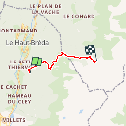
![](/images/other/stat-length.png)
![Randonnée Marche Le Haut-Bréda - refuge de l'Oule via le Lac du Léat - Photo](https://media.geolcdn.com/t/1900/400/ext.pjpeg?maxdim=2&url=https%3A%2F%2Fstatic1.geolcdn.com%2Fsiteimages%2Fupload%2Ffiles%2F1553511878bg_sport_marche.png)
refuge de l'Oule via le Lac du Léat
GuyVachet
Utilisateur
![Longueur](/images/other/stat-length.png)
![Altitude max](https://static1.geolcdn.com/siteimages/upload/files/1508320355ic_sort_altitude_max_24dp.png)
![Dénivelé positif](https://static1.geolcdn.com/siteimages/upload/files/1508320355ic_sort_den_pos_24dp.png)
![Km-Effort](/images/other/stat-length.png)
![Altitude min](https://static1.geolcdn.com/siteimages/upload/files/1508320355ic_sort_altitude_min_24dp.png)
![Dénivelé négatif](https://static1.geolcdn.com/siteimages/upload/files/1508320355ic_sort_den_neg_24dp.png)
![Boucle](https://static1.geolcdn.com/siteimages/upload/files/16400158638029165_repeat_loop_refresh_sync_direction_icon.png)
![Marche](https://static1.geolcdn.com/sitytour/trail-icons/101.png)
4h12
Difficulté : Moyen
![Scannez ce code QR pour ouvrir la randonnée dans l'application SityTrail](https://capi.geolives.com/qq0zvz2zws4bq2lad0pu/sitytour/trails/2170927/qr.png?size=200)
Application GPS de randonnée GRATUITE
À propos
Randonnée Marche de 7,1 km à découvrir à Auvergne-Rhône-Alpes, Isère, Le Haut-Bréda. Cette randonnée est proposée par GuyVachet.
Description
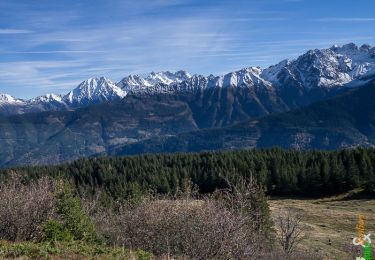
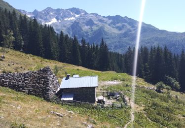
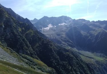
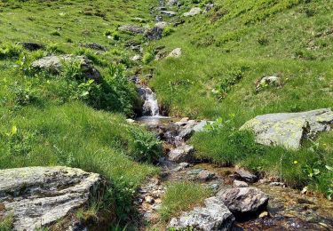
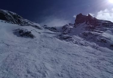
1er des 2 jours de la boucle pour découvrir les lacs de la Grande Valloire. La montée démarre en forêt à partir dans les premiers lacets de la route forestière au dessus du Grand Thiervoz. Quitter rapidement la piste pour le sentier en lacets (vieux panneau Tigneux) montée soutenue suivant la croupe. Au niveau du premier Chalet de Tigneux, obliquer Nord pour le lac du Léat via le Crêt du Tambour et enfin montée directe à la Croix du Léat. Montée à la Pierre du Pin (1904m) pour redescendre à l'alpage et montée finale au refuge de l'Oule afin d'accéder le jour suivant, aux très beaux panoramas des cols et lacs de la Grande Valloire.
Localisation
Commentaires
Randonnées à proximité
![Randonnée Marche Le Haut-Bréda - Lac Blanc Lac de la Folle - Photo](https://media.geolcdn.com/t/375/260/f4e38b80-48fc-49d4-b675-d255436e858e.jpg&format=jpg&maxdim=2)
![Marche Marche](https://static1.geolcdn.com/sitytour/trail-icons/101.png)
Marche
![](/images/other/stat-length.png)
![](https://static1.geolcdn.com/siteimages/upload/files/16400158638029165_repeat_loop_refresh_sync_direction_icon.png)
![Randonnée Marche Crêts-en-Belledonne - Le Grand Rocher 1926m, depuis le Foyer du Barioz - Photo](https://media.geolcdn.com/t/375/260/ext.jpg?maxdim=2&url=https%3A%2F%2Fservices.sitytrail.com%2FGeolivesWS%2FDownloadMedia.ashx%3FTrailID%3D317211%26Media%3D16386_1.jpg)
![Marche Marche](https://static1.geolcdn.com/sitytour/trail-icons/101.png)
Marche
![](/images/other/stat-length.png)
![](https://static1.geolcdn.com/siteimages/upload/files/16400158638029165_repeat_loop_refresh_sync_direction_icon.png)
![Randonnée Marche Le Haut-Bréda - Lac de Moretan avec bivouac - Photo](https://media.geolcdn.com/t/375/260/3f6f6c9a-9eda-4898-9aca-c8a8ce663caf.jpg&format=jpg&maxdim=2)
![Marche Marche](https://static1.geolcdn.com/sitytour/trail-icons/101.png)
Marche
![](/images/other/stat-length.png)
![](https://static1.geolcdn.com/siteimages/upload/files/16400158638029165_repeat_loop_refresh_sync_direction_icon.png)
![Randonnée Ski de randonnée Le Haut-Bréda - Col de Morétan - Photo](https://media.geolcdn.com/t/375/260/873ab7f9-f7ca-4112-a0d8-deee5e8e09db.jpg&format=jpg&maxdim=2)
![Ski de randonnée Ski de randonnée](https://static1.geolcdn.com/sitytour/trail-icons/503.png)
Ski de randonnée
![](/images/other/stat-length.png)
![](https://static1.geolcdn.com/siteimages/upload/files/16400158638029165_repeat_loop_refresh_sync_direction_icon.png)
![Randonnée Marche Le Haut-Bréda - Montagne de Périoule - Photo](https://media.geolcdn.com/t/375/260/2f5383cd-a0ab-4c06-9cbc-7601a3f9dca7.jpg&format=jpg&maxdim=2)
![Marche Marche](https://static1.geolcdn.com/sitytour/trail-icons/101.png)
Marche
![](/images/other/stat-length.png)
![](https://static1.geolcdn.com/siteimages/upload/files/16400158638029165_repeat_loop_refresh_sync_direction_icon.png)
![Randonnée Marche Le Haut-Bréda - Combe du Prat - Photo](https://media.geolcdn.com/t/375/260/6714bc1b-1337-4dda-8a6e-4ad571484b33.jpg&format=jpg&maxdim=2)
![Marche Marche](https://static1.geolcdn.com/sitytour/trail-icons/101.png)
Marche
![](/images/other/stat-length.png)
![](https://static1.geolcdn.com/siteimages/upload/files/16400158638029165_repeat_loop_refresh_sync_direction_icon.png)
![Randonnée Ski de randonnée Le Haut-Bréda - Belle Etoile et Pic des Cabottes couloir S - Photo](https://media.geolcdn.com/t/375/260/3f446dca-8587-476b-b4f9-492466f114e8.jpg&format=jpg&maxdim=2)
![Ski de randonnée Ski de randonnée](https://static1.geolcdn.com/sitytour/trail-icons/503.png)
Ski de randonnée
![](/images/other/stat-length.png)
![](https://static1.geolcdn.com/siteimages/upload/files/16400158638029165_repeat_loop_refresh_sync_direction_icon.png)
![Randonnée Marche Le Haut-Bréda - Les lacs sept Claux - Photo](https://media.geolcdn.com/t/375/260/ab2c771e-7afd-4d71-bf80-bad543cd1a27.jpg&format=jpg&maxdim=2)
![Marche Marche](https://static1.geolcdn.com/sitytour/trail-icons/101.png)
Marche
![](/images/other/stat-length.png)
![](https://static1.geolcdn.com/siteimages/upload/files/16400158638029165_repeat_loop_refresh_sync_direction_icon.png)
![Randonnée Marche Le Haut-Bréda - cascade du Pissou - Photo](https://media.geolcdn.com/t/375/260/7fdcfb11-ea55-4bb4-a796-d901baffbbd4.jpg&format=jpg&maxdim=2)
![Marche Marche](https://static1.geolcdn.com/sitytour/trail-icons/101.png)
Marche
![](/images/other/stat-length.png)
![](https://static1.geolcdn.com/siteimages/upload/files/16400158638029165_repeat_loop_refresh_sync_direction_icon.png)