![](/images/other/stat-length.png)
![Randonnée Marche Le Haut-Bréda - Cret du Poulet - Photo](https://media.geolcdn.com/t/1900/400/ext.pjpeg?maxdim=2&url=https%3A%2F%2Fstatic1.geolcdn.com%2Fsiteimages%2Fupload%2Ffiles%2F1553511878bg_sport_marche.png)
Cret du Poulet
patpounet73
Utilisateur
![Longueur](/images/other/stat-length.png)
![Altitude max](https://static1.geolcdn.com/siteimages/upload/files/1508320355ic_sort_altitude_max_24dp.png)
![Dénivelé positif](https://static1.geolcdn.com/siteimages/upload/files/1508320355ic_sort_den_pos_24dp.png)
![Km-Effort](/images/other/stat-length.png)
![Altitude min](https://static1.geolcdn.com/siteimages/upload/files/1508320355ic_sort_altitude_min_24dp.png)
![Dénivelé négatif](https://static1.geolcdn.com/siteimages/upload/files/1508320355ic_sort_den_neg_24dp.png)
![Boucle](https://static1.geolcdn.com/siteimages/upload/files/16400158638029165_repeat_loop_refresh_sync_direction_icon.png)
![Marche](https://static1.geolcdn.com/sitytour/trail-icons/101.png)
3h18
Difficulté : Moyen
![Scannez ce code QR pour ouvrir la randonnée dans l'application SityTrail](https://capi.geolives.com/qq0zvz2zws4bq2lad0pu/sitytour/trails/217057/qr.png?size=200)
Application GPS de randonnée GRATUITE
À propos
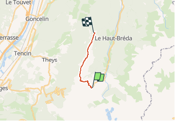
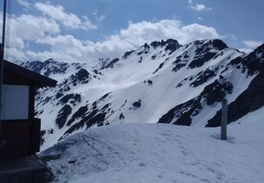
Randonnée Marche de 9,3 km à découvrir à Auvergne-Rhône-Alpes, Isère, Le Haut-Bréda. Cette randonnée est proposée par patpounet73.
Description
Départ du Pleynet, montée par la forêt (possibilité de monter par la piste, plus longue mais moins pentue) puis cheminement par les crêtes au travers des alpages jusqu'au refuge du Crêt du Poulet. Retour pas le même itinéraire. Attention la distance et le dénivelé indiqué ne sont calculés que pour l'aller. L'aller-retour est donc de 18,6 km avec un dénivelé global de 800 m. La seule difficulté est due à la distance. Trés beau panorama sur les vallées du Grésivaudan et du Bréda.
Localisation
Commentaires
Randonnées à proximité
![Randonnée Marche Le Haut-Bréda - Lac Blanc Lac de la Folle - Photo](https://media.geolcdn.com/t/375/260/f4e38b80-48fc-49d4-b675-d255436e858e.jpg&format=jpg&maxdim=2)
![Marche Marche](https://static1.geolcdn.com/sitytour/trail-icons/101.png)
Marche
![](/images/other/stat-length.png)
![](https://static1.geolcdn.com/siteimages/upload/files/16400158638029165_repeat_loop_refresh_sync_direction_icon.png)
![Randonnée Marche Les Adrets - les 7 laux - Photo](https://media.geolcdn.com/t/375/260/ext.jpg?maxdim=2&url=https%3A%2F%2Fservices.sitytrail.com%2FGeolivesWS%2FDownloadMedia.ashx%3FTrailID%3D210621%26Media%3Dfix__20130806134428.jpg)
![Marche Marche](https://static1.geolcdn.com/sitytour/trail-icons/101.png)
Marche
![](/images/other/stat-length.png)
![](https://static1.geolcdn.com/siteimages/upload/files/16400158638029165_repeat_loop_refresh_sync_direction_icon.png)
![Randonnée Marche Le Haut-Bréda - Combe du Prat - Photo](https://media.geolcdn.com/t/375/260/6714bc1b-1337-4dda-8a6e-4ad571484b33.jpg&format=jpg&maxdim=2)
![Marche Marche](https://static1.geolcdn.com/sitytour/trail-icons/101.png)
Marche
![](/images/other/stat-length.png)
![](https://static1.geolcdn.com/siteimages/upload/files/16400158638029165_repeat_loop_refresh_sync_direction_icon.png)
![Randonnée Ski de randonnée Le Haut-Bréda - Belle Etoile et Pic des Cabottes couloir S - Photo](https://media.geolcdn.com/t/375/260/3f446dca-8587-476b-b4f9-492466f114e8.jpg&format=jpg&maxdim=2)
![Ski de randonnée Ski de randonnée](https://static1.geolcdn.com/sitytour/trail-icons/503.png)
Ski de randonnée
![](/images/other/stat-length.png)
![](https://static1.geolcdn.com/siteimages/upload/files/16400158638029165_repeat_loop_refresh_sync_direction_icon.png)
![Randonnée Ski de randonnée Les Adrets - le jas de lièvre et vol de Bédina - Photo](https://media.geolcdn.com/t/375/260/fb6d4008-e294-44a8-86f0-b378b0a893a8.jpg&format=jpg&maxdim=2)
![Ski de randonnée Ski de randonnée](https://static1.geolcdn.com/sitytour/trail-icons/503.png)
Ski de randonnée
![](/images/other/stat-length.png)
![](https://static1.geolcdn.com/siteimages/upload/files/16400158638029165_repeat_loop_refresh_sync_direction_icon.png)
![Randonnée V.T.T. Theys - Autour du crêt de Chazay - Photo](https://media.geolcdn.com/t/375/260/ext.jpg?maxdim=2&url=https%3A%2F%2Fstatic1.geolcdn.com%2Fsiteimages%2Fupload%2Ffiles%2F1524743154velo.jpg)
![V.T.T. V.T.T.](https://static1.geolcdn.com/sitytour/trail-icons/202.png)
V.T.T.
![](/images/other/stat-length.png)
![](https://static1.geolcdn.com/siteimages/upload/files/16400158638029165_repeat_loop_refresh_sync_direction_icon.png)
![Randonnée Marche Le Haut-Bréda - Les lacs sept Claux - Photo](https://media.geolcdn.com/t/375/260/ab2c771e-7afd-4d71-bf80-bad543cd1a27.jpg&format=jpg&maxdim=2)
![Marche Marche](https://static1.geolcdn.com/sitytour/trail-icons/101.png)
Marche
![](/images/other/stat-length.png)
![](https://static1.geolcdn.com/siteimages/upload/files/16400158638029165_repeat_loop_refresh_sync_direction_icon.png)
![Randonnée Marche Le Haut-Bréda - cascade du Pissou - Photo](https://media.geolcdn.com/t/375/260/7fdcfb11-ea55-4bb4-a796-d901baffbbd4.jpg&format=jpg&maxdim=2)
![Marche Marche](https://static1.geolcdn.com/sitytour/trail-icons/101.png)
Marche
![](/images/other/stat-length.png)
![](https://static1.geolcdn.com/siteimages/upload/files/16400158638029165_repeat_loop_refresh_sync_direction_icon.png)
![Randonnée Ski de randonnée Le Haut-Bréda - cime de la Jase, col de la pouta, col de l'évêque - Photo](https://media.geolcdn.com/t/375/260/398c2455-32f4-45bc-ac0e-2e98301f4be7.jpg&format=jpg&maxdim=2)
![Ski de randonnée Ski de randonnée](https://static1.geolcdn.com/sitytour/trail-icons/503.png)
Ski de randonnée
![](/images/other/stat-length.png)
![](https://static1.geolcdn.com/siteimages/upload/files/16400158638029165_repeat_loop_refresh_sync_direction_icon.png)