![](/images/other/stat-length.png)
![Randonnée Marche Montrevault-sur-Èvre - Montrevault 3 - Photo](https://media.geolcdn.com/t/1900/400/ext.pjpeg?maxdim=2&url=https%3A%2F%2Fstatic1.geolcdn.com%2Fsiteimages%2Fupload%2Ffiles%2F1553511878bg_sport_marche.png)
Montrevault 3
PatrickMatuszewski
Utilisateur
![Longueur](/images/other/stat-length.png)
Longueur
17 km
![Altitude max](https://static1.geolcdn.com/siteimages/upload/files/1508320355ic_sort_altitude_max_24dp.png)
Altitude max
103 m
![Dénivelé positif](https://static1.geolcdn.com/siteimages/upload/files/1508320355ic_sort_den_pos_24dp.png)
Dénivelé positif
312 m
![Km-Effort](/images/other/stat-length.png)
Km-Effort
21 km
![Altitude min](https://static1.geolcdn.com/siteimages/upload/files/1508320355ic_sort_altitude_min_24dp.png)
Altitude min
21 m
![Dénivelé négatif](https://static1.geolcdn.com/siteimages/upload/files/1508320355ic_sort_den_neg_24dp.png)
Dénivelé négatif
314 m
![Boucle](https://static1.geolcdn.com/siteimages/upload/files/16400158638029165_repeat_loop_refresh_sync_direction_icon.png)
Boucle
Oui
Date de création :
2016-12-04 00:00:00.0
Dernière modification :
2016-12-04 00:00:00.0
![Marche](https://static1.geolcdn.com/sitytour/trail-icons/101.png)
4h39
Difficulté : Très facile
![Scannez ce code QR pour ouvrir la randonnée dans l'application SityTrail](https://capi.geolives.com/qq0zvz2zws4bq2lad0pu/sitytour/trails/216874/qr.png?size=200)
Application GPS de randonnée GRATUITE
À propos
Randonnée Marche de 17 km à découvrir à Pays de la Loire, Maine-et-Loire, Montrevault-sur-Èvre. Cette randonnée est proposée par PatrickMatuszewski.
Description
Montrevault Chemin bleu Attention le petit Perray: Fermier pas agréable et refuse le passage qui est pourtant balisé.
Localisation
Pays :
France
Région :
Pays de la Loire
Département/Province :
Maine-et-Loire
Commune :
Montrevault-sur-Èvre
Localité :
Unknown
Départ:(Dec)
Départ:(UTM)
647878 ; 5236092 (30T) N.
Commentaires
Randonnées à proximité
![Randonnée Marche Montrevault-sur-Èvre - le moulin du GOUAS ST Pierre Montlimart - Photo](https://media.geolcdn.com/t/375/260/0d3570cf-5fa9-42fc-9d02-ee9b967646f2.jpg&format=jpg&maxdim=2)
![Marche Marche](https://static1.geolcdn.com/sitytour/trail-icons/101.png)
le moulin du GOUAS ST Pierre Montlimart
Marche
Moyen
Montrevault-sur-Èvre,
Pays de la Loire,
Maine-et-Loire,
France
![](/images/other/stat-length.png)
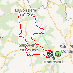
8,2 km | 9,8 km-effort
2h 31min
![](https://static1.geolcdn.com/siteimages/upload/files/16400158638029165_repeat_loop_refresh_sync_direction_icon.png)
Oui
![Randonnée Marche Montrevault-sur-Èvre - St Rémy en mauges - Photo](https://media.geolcdn.com/t/375/260/bdbe4416-8aff-4641-bf20-65247de902cd.jpg&format=jpg&maxdim=2)
![Marche Marche](https://static1.geolcdn.com/sitytour/trail-icons/101.png)
St Rémy en mauges
Marche
Difficile
Montrevault-sur-Èvre,
Pays de la Loire,
Maine-et-Loire,
France
![](/images/other/stat-length.png)
28 km | 34 km-effort
5h 22min
![](https://static1.geolcdn.com/siteimages/upload/files/16400158638029165_repeat_loop_refresh_sync_direction_icon.png)
Oui
![Randonnée Marche Montrevault-sur-Èvre - Montrevault - Photo](https://media.geolcdn.com/t/375/260/ext.jpg?maxdim=2&url=https%3A%2F%2Fstatic1.geolcdn.com%2Fsiteimages%2Fupload%2Ffiles%2F1553511878bg_sport_marche.png)
![Marche Marche](https://static1.geolcdn.com/sitytour/trail-icons/101.png)
Montrevault
Marche
Facile
Montrevault-sur-Èvre,
Pays de la Loire,
Maine-et-Loire,
France
![](/images/other/stat-length.png)
8,7 km | 10,8 km-effort
2h 19min
![](https://static1.geolcdn.com/siteimages/upload/files/16400158638029165_repeat_loop_refresh_sync_direction_icon.png)
Oui
![Randonnée Marche Mauges-sur-Loire - Botz en Mauges - Photo](https://media.geolcdn.com/t/375/260/ext.jpg?maxdim=2&url=https%3A%2F%2Fstatic1.geolcdn.com%2Fsiteimages%2Fupload%2Ffiles%2F1553511878bg_sport_marche.png)
![Marche Marche](https://static1.geolcdn.com/sitytour/trail-icons/101.png)
Botz en Mauges
Marche
Facile
Mauges-sur-Loire,
Pays de la Loire,
Maine-et-Loire,
France
![](/images/other/stat-length.png)
11,1 km | 13,3 km-effort
3h 4min
![](https://static1.geolcdn.com/siteimages/upload/files/16400158638029165_repeat_loop_refresh_sync_direction_icon.png)
Oui
![Randonnée Marche Montrevault-sur-Èvre - Du Buis à la Trezenne-La Boissiere sur Evre - Photo](https://media.geolcdn.com/t/375/260/ext.jpg?maxdim=2&url=https%3A%2F%2Fstatic1.geolcdn.com%2Fsiteimages%2Fupload%2Ffiles%2F1553511878bg_sport_marche.png)
![Marche Marche](https://static1.geolcdn.com/sitytour/trail-icons/101.png)
Du Buis à la Trezenne-La Boissiere sur Evre
Marche
Moyen
Montrevault-sur-Èvre,
Pays de la Loire,
Maine-et-Loire,
France
![](/images/other/stat-length.png)
15 km | 17,6 km-effort
3h 56min
![](https://static1.geolcdn.com/siteimages/upload/files/16400158638029165_repeat_loop_refresh_sync_direction_icon.png)
Oui
![Randonnée Marche Mauges-sur-Loire - Au fil du St Laurent - Photo](https://media.geolcdn.com/t/375/260/ext.jpg?maxdim=2&url=https%3A%2F%2Fstatic1.geolcdn.com%2Fsiteimages%2Fupload%2Ffiles%2F1553511878bg_sport_marche.png)
![Marche Marche](https://static1.geolcdn.com/sitytour/trail-icons/101.png)
Au fil du St Laurent
Marche
Facile
Mauges-sur-Loire,
Pays de la Loire,
Maine-et-Loire,
France
![](/images/other/stat-length.png)
9,4 km | 11,2 km-effort
2h 27min
![](https://static1.geolcdn.com/siteimages/upload/files/16400158638029165_repeat_loop_refresh_sync_direction_icon.png)
Oui
![Randonnée Marche Montrevault-sur-Èvre - variante St jacques de Compostelle Montrevault-Beaupréau - Photo](https://media.geolcdn.com/t/375/260/ext.jpg?maxdim=2&url=https%3A%2F%2Fstatic1.geolcdn.com%2Fsiteimages%2Fupload%2Ffiles%2F1553511878bg_sport_marche.png)
![Marche Marche](https://static1.geolcdn.com/sitytour/trail-icons/101.png)
variante St jacques de Compostelle Montrevault-Beaupréau
Marche
Moyen
Montrevault-sur-Èvre,
Pays de la Loire,
Maine-et-Loire,
France
![](/images/other/stat-length.png)
19 km | 24 km-effort
5h 8min
![](https://static1.geolcdn.com/siteimages/upload/files/16400158638029165_repeat_loop_refresh_sync_direction_icon.png)
Non
![Randonnée V.T.T. Montrevault-sur-Èvre - Mont Rebel - Photo](https://media.geolcdn.com/t/375/260/ext.jpg?maxdim=2&url=https%3A%2F%2Fstatic1.geolcdn.com%2Fsiteimages%2Fupload%2Ffiles%2F1524743154velo.jpg)
![V.T.T. V.T.T.](https://static1.geolcdn.com/sitytour/trail-icons/202.png)
Mont Rebel
V.T.T.
Difficile
Montrevault-sur-Èvre,
Pays de la Loire,
Maine-et-Loire,
France
![](/images/other/stat-length.png)
19,9 km | 25 km-effort
1h 30min
![](https://static1.geolcdn.com/siteimages/upload/files/16400158638029165_repeat_loop_refresh_sync_direction_icon.png)
Oui
![Randonnée Marche Montrevault-sur-Èvre - Le Fief Sauvin - Photo](https://media.geolcdn.com/t/375/260/ext.jpg?maxdim=2&url=https%3A%2F%2Fstatic1.geolcdn.com%2Fsiteimages%2Fupload%2Ffiles%2F1553511878bg_sport_marche.png)
![Marche Marche](https://static1.geolcdn.com/sitytour/trail-icons/101.png)
Le Fief Sauvin
Marche
Facile
Montrevault-sur-Èvre,
Pays de la Loire,
Maine-et-Loire,
France
![](/images/other/stat-length.png)
31 km | 37 km-effort
6h 9min
![](https://static1.geolcdn.com/siteimages/upload/files/16400158638029165_repeat_loop_refresh_sync_direction_icon.png)
Oui