Randonnée Marche Moissac-Vallée-Française - saumane - Photo
 patmess
patmess

Utilisateur

© OpenStreetMap contributors
Longueur
Longueur
14,3 km
Altitude max
Altitude max
746 m
Dénivelé positif
Dénivelé positif
493 m
Km-Effort
Km-Effort  
21 km
Altitude min
Altitude min
323 m
Dénivelé négatif
Dénivelé négatif
494 m
Boucle
Boucle
Oui
Date de création :
2019-08-12 12:15:37.119
Dernière modification :
2019-08-20 12:47:56.755

(0 Avis)

Marche
Marche
5h20
Difficulté : Facile

Scannez ce code QR pour ouvrir la randonnée dans l'application SityTrail

Application GPS de randonnée GRATUITE

Logo SityTrail SityTrail

IGN / Instituts géographiques

Télécharger SityTrail sur l'App Store Télécharger SityTrail sur Google Play

Logo SityTrail SityTrail World

Le monde est à vous

Télécharger SityTrail sur l'App Store Télécharger SityTrail sur Google Play Télécharger SityTrail sur Huawei AppGallery

À propos

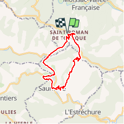
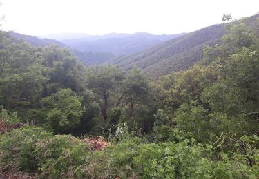
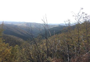
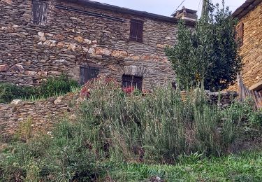
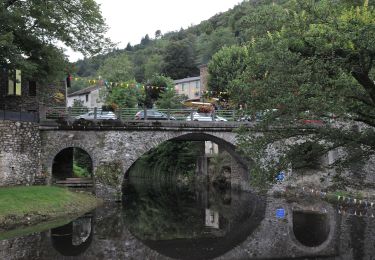
Randonnée Marche de 14,3 km à découvrir à Occitanie, Lozère, Moissac-Vallée-Française. Cette randonnée est proposée par patmess.

Profil altimétrique

Photos

Localisation

Pays :
France
Région :
Occitanie
Département/Province :
Lozère
Commune :
Moissac-Vallée-Française
Localité :
Unknown
Départ:(UTM)
561744 ; 4888570 (31T) N.

Randonnées à proximité

Randonnée Marche Les Plantiers - Sentier de Saint Marcel de Fontfouillouse -  Les Plantiers - Photo
Marche
tracegps

Marche

Très difficile
(1)
Les Plantiers, Occitanie, Gard, France
13,6 km | 21 km-effort
4h 0min
Oui
Randonnée A pied Gabriac - Sentier de Gabriac - Photo
A pied
GUIDE+

A pied

Facile
Gabriac, Occitanie, Lozère, France
9,3 km | 15,5 km-effort
3h 31min
Oui
Randonnée Marche Saumane - Exil / pont des chèvres  - Photo
Marche
GUIDE
nadinebondoux

Marche

Difficile
Saumane, Occitanie, Gard, France
17,3 km | 27 km-effort
5h 53min
Oui
Randonnée Marche Peyrolles - la Diligence  - Photo
Marche
GUIDE
nadinebondoux

Marche

Moyen
Peyrolles, Occitanie, Gard, France
15,3 km | 0 m-effort
4h 47min
Oui
Randonnée Marche Les Plantiers - vallée Borgne - Photo
Marche
GUIDE
nadinebondoux

Marche

Difficile
Les Plantiers, Occitanie, Gard, France
25 km | 36 km-effort
6h 15min
Oui
Randonnée Marche Les Plantiers - Les Plantiers et st Marcel de Fontfouillouse - Photo
Marche
GUIDE
randotines

Marche

Difficile
(1)
Les Plantiers, Occitanie, Gard, France
13,6 km | 21 km-effort
4h 33min
Oui
Randonnée Marche L'Estréchure - sentier du soult -  - Photo
Marche
campingmasdelacam

Marche

Difficile
L'Estréchure, Occitanie, Gard, France
10,3 km | 17,1 km-effort
3h 52min
Oui
Randonnée Marche Saint-Étienne-Vallée-Française - Montagne vieille morte - Photo
Marche
GUIDE
nadinebondoux

Marche

Difficile
Saint-Étienne-Vallée-Française, Occitanie, Lozère, France
24 km | 36 km-effort
6h 54min
Oui
Randonnée A pied Les Plantiers - Sentier de Fontfouillouse - Photo
A pied
GUIDE+

A pied

Facile
Les Plantiers, Occitanie, Gard, France
9,2 km | 15,2 km-effort
3h 27min
Non


Fermer
Mes abonnements