![](/images/other/stat-length.png)
![Randonnée Marche Dienville - Dienville pour le Matin - Photo](https://media.geolcdn.com/t/1900/400/c60828f8-5748-4aec-bc0b-8a0ab51d7958.jpg&format=pjpeg&maxdim=2)
Dienville pour le Matin
VANDERPUTTENMi
Utilisateur GUIDE
![Longueur](/images/other/stat-length.png)
Longueur
8,6 km
![Altitude max](https://static1.geolcdn.com/siteimages/upload/files/1508320355ic_sort_altitude_max_24dp.png)
Altitude max
157 m
![Dénivelé positif](https://static1.geolcdn.com/siteimages/upload/files/1508320355ic_sort_den_pos_24dp.png)
Dénivelé positif
62 m
![Km-Effort](/images/other/stat-length.png)
Km-Effort
9,4 km
![Altitude min](https://static1.geolcdn.com/siteimages/upload/files/1508320355ic_sort_altitude_min_24dp.png)
Altitude min
125 m
![Dénivelé négatif](https://static1.geolcdn.com/siteimages/upload/files/1508320355ic_sort_den_neg_24dp.png)
Dénivelé négatif
62 m
![Boucle](https://static1.geolcdn.com/siteimages/upload/files/16400158638029165_repeat_loop_refresh_sync_direction_icon.png)
Boucle
Oui
Date de création :
2019-08-08 14:32:32.358
Dernière modification :
2019-08-08 14:43:48.436
![Marche](https://static1.geolcdn.com/sitytour/trail-icons/101.png)
2h06
Difficulté : Moyen
![Scannez ce code QR pour ouvrir la randonnée dans l'application SityTrail](https://capi.geolives.com/qq0zvz2zws4bq2lad0pu/sitytour/trails/2164062/qr.png?size=200)
Application GPS de randonnée GRATUITE
À propos
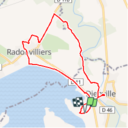
Randonnée Marche de 8,6 km à découvrir à Grand Est, Aube, Dienville. Cette randonnée est proposée par VANDERPUTTENMi.
Description
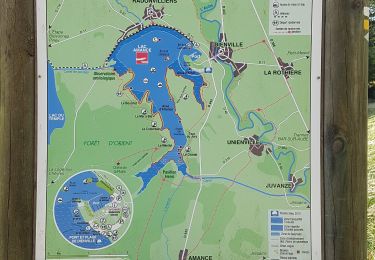
Départ depuis l'espace de jeu, regagner la digue jusque Radonviller que l'on traverse ensuivant un balisage jaune et que l'on suit jusque Dienville.
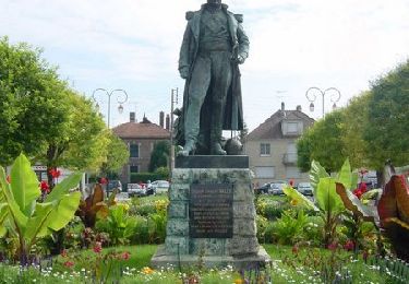
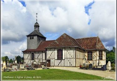
Rentrer dans le village pour voir l'église et le marché, revenir au port en passant par la chapelle du Tertre
Localisation
Pays :
France
Région :
Grand Est
Département/Province :
Aube
Commune :
Dienville
Localité :
Unknown
Départ:(Dec)
Départ:(UTM)
613053 ; 5355774 (31U) N.
Commentaires
Randonnées à proximité
![Randonnée Marche Dienville - Le Balcon du Lac d'Amance - Photo](https://media.geolcdn.com/t/375/260/ext.jpg?maxdim=2&url=https%3A%2F%2Fservices.sitytrail.com%2FGeolivesWS%2FDownloadMedia.ashx%3FTrailID%3D109386%26Media%3D3713_1.jpg)
![Marche Marche](https://static1.geolcdn.com/sitytour/trail-icons/101.png)
Le Balcon du Lac d'Amance
Marche
Difficile
(1)
Dienville,
Grand Est,
Aube,
France
![](/images/other/stat-length.png)
17,5 km | 19,7 km-effort
4h 45min
![](https://static1.geolcdn.com/siteimages/upload/files/16400158638029165_repeat_loop_refresh_sync_direction_icon.png)
Oui
![Randonnée Marche Dienville - Dienville du 3/07/2016 - Photo](https://media.geolcdn.com/t/375/260/e4fa4f5f-4cbd-44e5-9044-1ad50a5d7595.jpg&format=jpg&maxdim=2)
![Marche Marche](https://static1.geolcdn.com/sitytour/trail-icons/101.png)
Dienville du 3/07/2016
Marche
Très facile
Dienville,
Grand Est,
Aube,
France
![](/images/other/stat-length.png)
18,9 km | 21 km-effort
5h 21min
![](https://static1.geolcdn.com/siteimages/upload/files/16400158638029165_repeat_loop_refresh_sync_direction_icon.png)
Non
![Randonnée Marche Dienville - 2017 05 05 à 14h59m26 Lac Amance - Photo](https://media.geolcdn.com/t/375/260/ext.jpg?maxdim=2&url=https%3A%2F%2Fstatic1.geolcdn.com%2Fsiteimages%2Fupload%2Ffiles%2F1553511878bg_sport_marche.png)
![Marche Marche](https://static1.geolcdn.com/sitytour/trail-icons/101.png)
2017 05 05 à 14h59m26 Lac Amance
Marche
Très facile
(1)
Dienville,
Grand Est,
Aube,
France
![](/images/other/stat-length.png)
13,9 km | 15,5 km-effort
2h 40min
![](https://static1.geolcdn.com/siteimages/upload/files/16400158638029165_repeat_loop_refresh_sync_direction_icon.png)
Oui
![Randonnée Marche Brienne-le-Château - Promenade Briennoise - Brienne-le-Château - Photo](https://media.geolcdn.com/t/375/260/ext.jpg?maxdim=2&url=https%3A%2F%2Fservices.sitytrail.com%2FGeolivesWS%2FDownloadMedia.ashx%3FTrailID%3D173244%26Media%3D14854_6.jpg)
![Marche Marche](https://static1.geolcdn.com/sitytour/trail-icons/101.png)
Promenade Briennoise - Brienne-le-Château
Marche
Moyen
(1)
Brienne-le-Château,
Grand Est,
Aube,
France
![](/images/other/stat-length.png)
7,4 km | 8,4 km-effort
2h 0min
![](https://static1.geolcdn.com/siteimages/upload/files/16400158638029165_repeat_loop_refresh_sync_direction_icon.png)
Oui
![Randonnée Vélo Dienville - Les pans de bois et le lac Amance - Dienville - Photo](https://media.geolcdn.com/t/375/260/ext.jpg?maxdim=2&url=https%3A%2F%2Fservices.sitytrail.com%2FGeolivesWS%2FDownloadMedia.ashx%3FTrailID%3D112801%26Media%3D12457_5.jpg)
![Vélo Vélo](https://static1.geolcdn.com/sitytour/trail-icons/200.png)
Les pans de bois et le lac Amance - Dienville
Vélo
Moyen
Dienville,
Grand Est,
Aube,
France
![](/images/other/stat-length.png)
32 km | 36 km-effort
1h 45min
![](https://static1.geolcdn.com/siteimages/upload/files/16400158638029165_repeat_loop_refresh_sync_direction_icon.png)
Oui
![Randonnée Marche Unienville - Chemin de Compostelle, Voie de Vézelay GR654® De Unienville à La Loge aux Chèvres - Photo](https://media.geolcdn.com/t/375/260/ext.jpg?maxdim=2&url=https%3A%2F%2Fservices.sitytrail.com%2FGeolivesWS%2FDownloadMedia.ashx%3FTrailID%3D109410%26Media%3D3741_1.jpg)
![Marche Marche](https://static1.geolcdn.com/sitytour/trail-icons/101.png)
Chemin de Compostelle, Voie de Vézelay GR654® De Unienville à La Loge aux Chè...
Marche
Moyen
Unienville,
Grand Est,
Aube,
France
![](/images/other/stat-length.png)
14,7 km | 17,1 km-effort
3h 0min
![](https://static1.geolcdn.com/siteimages/upload/files/16400158638029165_repeat_loop_refresh_sync_direction_icon.png)
Non
![Randonnée Marche Dienville - dienville - Photo](https://media.geolcdn.com/t/375/260/d11ba040-fd06-44ab-8a1c-197bb16eb082.jpg&format=jpg&maxdim=2)
![Marche Marche](https://static1.geolcdn.com/sitytour/trail-icons/101.png)
dienville
Marche
Très facile
Dienville,
Grand Est,
Aube,
France
![](/images/other/stat-length.png)
16,2 km | 18,1 km-effort
3h 31min
![](https://static1.geolcdn.com/siteimages/upload/files/16400158638029165_repeat_loop_refresh_sync_direction_icon.png)
Non
![Randonnée Marche Dienville - Le Balcon du Lac d'Amance - Photo](https://media.geolcdn.com/t/375/260/ext.jpg?maxdim=2&url=https%3A%2F%2Fstatic1.geolcdn.com%2Fsiteimages%2Fupload%2Ffiles%2F1553511878bg_sport_marche.png)
![Marche Marche](https://static1.geolcdn.com/sitytour/trail-icons/101.png)
Le Balcon du Lac d'Amance
Marche
Difficile
Dienville,
Grand Est,
Aube,
France
![](/images/other/stat-length.png)
17,5 km | 19,7 km-effort
4h 45min
![](https://static1.geolcdn.com/siteimages/upload/files/16400158638029165_repeat_loop_refresh_sync_direction_icon.png)
Oui
![Randonnée Marche Dienville - séjour mesnil St père 26 03 - Photo](https://media.geolcdn.com/t/375/260/ext.jpg?maxdim=2&url=https%3A%2F%2Fstatic1.geolcdn.com%2Fsiteimages%2Fupload%2Ffiles%2F1553511878bg_sport_marche.png)
![Marche Marche](https://static1.geolcdn.com/sitytour/trail-icons/101.png)
séjour mesnil St père 26 03
Marche
Difficile
Dienville,
Grand Est,
Aube,
France
![](/images/other/stat-length.png)
11,9 km | 13 km-effort
3h 26min
![](https://static1.geolcdn.com/siteimages/upload/files/16400158638029165_repeat_loop_refresh_sync_direction_icon.png)
Oui