![](/images/other/stat-length.png)
![Randonnée Marche Livarot-Pays-d'Auge - Cerqueux - Photo](https://media.geolcdn.com/t/1900/400/2f45acee-67f3-45b7-9c60-c3e7bdd88b3b.jpg&format=pjpeg&maxdim=2)
Cerqueux
Eve - Line
Utilisateur
![Longueur](/images/other/stat-length.png)
Longueur
8,2 km
![Altitude max](https://static1.geolcdn.com/siteimages/upload/files/1508320355ic_sort_altitude_max_24dp.png)
Altitude max
206 m
![Dénivelé positif](https://static1.geolcdn.com/siteimages/upload/files/1508320355ic_sort_den_pos_24dp.png)
Dénivelé positif
74 m
![Km-Effort](/images/other/stat-length.png)
Km-Effort
9,1 km
![Altitude min](https://static1.geolcdn.com/siteimages/upload/files/1508320355ic_sort_altitude_min_24dp.png)
Altitude min
164 m
![Dénivelé négatif](https://static1.geolcdn.com/siteimages/upload/files/1508320355ic_sort_den_neg_24dp.png)
Dénivelé négatif
74 m
![Boucle](https://static1.geolcdn.com/siteimages/upload/files/16400158638029165_repeat_loop_refresh_sync_direction_icon.png)
Boucle
Oui
Date de création :
2019-08-07 11:31:53.815
Dernière modification :
2019-08-07 13:41:46.409
![Marche](https://static1.geolcdn.com/sitytour/trail-icons/101.png)
2h08
Difficulté : Facile
![Scannez ce code QR pour ouvrir la randonnée dans l'application SityTrail](https://capi.geolives.com/qq0zvz2zws4bq2lad0pu/sitytour/trails/2162931/qr.png?size=200)
Application GPS de randonnée GRATUITE
À propos
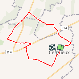
Randonnée Marche de 8,2 km à découvrir à Normandie, Calvados, Livarot-Pays-d'Auge. Cette randonnée est proposée par Eve - Line.
Description
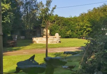
Départ église de Cerqueux. Prendre en photo le circuit et suivre le balisage de randonnée bleu. La photo du circuit servira de plan car le balisage est manquant à certains endroits. Bonne rando
Localisation
Pays :
France
Région :
Normandie
Département/Province :
Calvados
Commune :
Livarot-Pays-d'Auge
Localité :
Unknown
Départ:(Dec)
Départ:(UTM)
307051 ; 5430168 (31U) N.
Commentaires
Randonnées à proximité
![Randonnée Marche Cernay - A l'Est de Cernay - Photo](https://media.geolcdn.com/t/375/260/ext.jpg?maxdim=2&url=https%3A%2F%2Fservices.sitytrail.com%2FGeolivesWS%2FDownloadMedia.ashx%3FTrailID%3D317507%26Media%3D16746_6.jpg)
![Marche Marche](https://static1.geolcdn.com/sitytour/trail-icons/101.png)
A l'Est de Cernay
Marche
Moyen
(1)
Cernay,
Normandie,
Calvados,
France
![](/images/other/stat-length.png)
8 km | 9,5 km-effort
2h 0min
![](https://static1.geolcdn.com/siteimages/upload/files/16400158638029165_repeat_loop_refresh_sync_direction_icon.png)
Oui
![Randonnée Marche Cernay - Au sud de Cernay - Photo](https://media.geolcdn.com/t/375/260/ext.jpg?maxdim=2&url=https%3A%2F%2Fservices.sitytrail.com%2FGeolivesWS%2FDownloadMedia.ashx%3FTrailID%3D317506%26Media%3D16744_6.jpg)
![Marche Marche](https://static1.geolcdn.com/sitytour/trail-icons/101.png)
Au sud de Cernay
Marche
Moyen
Cernay,
Normandie,
Calvados,
France
![](/images/other/stat-length.png)
13,8 km | 15,8 km-effort
3h 10min
![](https://static1.geolcdn.com/siteimages/upload/files/16400158638029165_repeat_loop_refresh_sync_direction_icon.png)
Oui
![Randonnée Moteur Cernay - Cernay-Bernay13/10/13 - Photo](https://media.geolcdn.com/t/375/260/ext.jpg?maxdim=2&url=https%3A%2F%2Fstatic1.geolcdn.com%2Fsiteimages%2Fupload%2Ffiles%2F15247431544x4.jpg)
![Moteur Moteur](https://static1.geolcdn.com/sitytour/trail-icons/400.png)
Cernay-Bernay13/10/13
Moteur
Très facile
(1)
Cernay,
Normandie,
Calvados,
France
![](/images/other/stat-length.png)
33 km | 38 km-effort
1h 0min
![](https://static1.geolcdn.com/siteimages/upload/files/16400158638029165_repeat_loop_refresh_sync_direction_icon.png)
Non
![Randonnée Marche Livarot-Pays-d'Auge - Cerqueux (14) - Photo](https://media.geolcdn.com/t/375/260/fa66af0f-7d93-434d-88a9-997e464e8dc8.jpg&format=jpg&maxdim=2)
![Marche Marche](https://static1.geolcdn.com/sitytour/trail-icons/101.png)
Cerqueux (14)
Marche
Moyen
Livarot-Pays-d'Auge,
Normandie,
Calvados,
France
![](/images/other/stat-length.png)
15,8 km | 18,1 km-effort
3h 43min
![](https://static1.geolcdn.com/siteimages/upload/files/16400158638029165_repeat_loop_refresh_sync_direction_icon.png)
Oui
![Randonnée Marche Cernay - Cernay - Photo](https://media.geolcdn.com/t/375/260/03fd9fe7-3bc3-40b8-9afd-a9b466cf0429.jpg&format=jpg&maxdim=2)
![Marche Marche](https://static1.geolcdn.com/sitytour/trail-icons/101.png)
![Randonnée 4x4 Livarot-Pays-d'Auge - Sortie après midi 19/01/2020 - Photo](https://media.geolcdn.com/t/375/260/11ac66eb-d1b2-4f2b-bc0a-5b40b7846ffa.jpg&format=jpg&maxdim=2)
![4x4 4x4](https://static1.geolcdn.com/sitytour/trail-icons/403.png)
Sortie après midi 19/01/2020
4x4
Livarot-Pays-d'Auge,
Normandie,
Calvados,
France
![](/images/other/stat-length.png)
57 km | 68 km-effort
3h 44min
![](https://static1.geolcdn.com/siteimages/upload/files/16400158638029165_repeat_loop_refresh_sync_direction_icon.png)
Non
![Randonnée Marche La Vespière-Friardel - La Vespiere - Photo](https://media.geolcdn.com/t/375/260/da48bb98-df54-46a8-9e2f-aee2a972f759.jpg&format=jpg&maxdim=2)
![Marche Marche](https://static1.geolcdn.com/sitytour/trail-icons/101.png)
La Vespiere
Marche
Moyen
La Vespière-Friardel,
Normandie,
Calvados,
France
![](/images/other/stat-length.png)
22 km | 27 km-effort
4h 22min
![](https://static1.geolcdn.com/siteimages/upload/files/16400158638029165_repeat_loop_refresh_sync_direction_icon.png)
Oui
![Randonnée Marche Livarot-Pays-d'Auge - Balade autour de Préaux St Sébastien - Photo](https://media.geolcdn.com/t/375/260/ext.jpg?maxdim=2&url=https%3A%2F%2Fservices.sitytrail.com%2FGeolivesWS%2FDownloadMedia.ashx%3FTrailID%3D172980%26Media%3D14471_2.jpg)
![Marche Marche](https://static1.geolcdn.com/sitytour/trail-icons/101.png)
Balade autour de Préaux St Sébastien
Marche
Moyen
Livarot-Pays-d'Auge,
Normandie,
Calvados,
France
![](/images/other/stat-length.png)
17,6 km | 19,8 km-effort
3h 30min
![](https://static1.geolcdn.com/siteimages/upload/files/16400158638029165_repeat_loop_refresh_sync_direction_icon.png)
Oui
![Randonnée Marche La Folletière-Abenon - Source de l'Orbiquet avec Cressonnière - Photo](https://media.geolcdn.com/t/375/260/ext.jpg?maxdim=2&url=https%3A%2F%2Fstatic1.geolcdn.com%2Fsiteimages%2Fupload%2Ffiles%2F1553511878bg_sport_marche.png)
![Marche Marche](https://static1.geolcdn.com/sitytour/trail-icons/101.png)
Source de l'Orbiquet avec Cressonnière
Marche
Facile
La Folletière-Abenon,
Normandie,
Calvados,
France
![](/images/other/stat-length.png)
14,1 km | 17,5 km-effort
3h 58min
![](https://static1.geolcdn.com/siteimages/upload/files/16400158638029165_repeat_loop_refresh_sync_direction_icon.png)
Oui