Randonnée Marche Ris-Orangis - Evry PR47 - Photo
 aucamus
aucamus

Utilisateur

© OpenStreetMap contributors
Longueur
Longueur
8,1 km
Altitude max
Altitude max
82 m
Dénivelé positif
Dénivelé positif
89 m
Km-Effort
Km-Effort  
9,3 km
Altitude min
Altitude min
26 m
Dénivelé négatif
Dénivelé négatif
92 m
Boucle
Boucle
Oui
Date de création :
2019-08-06 09:47:38.378
Dernière modification :
2019-08-06 09:49:03.718

(0 Avis)

Marche
Marche
2h02
Difficulté : Très facile

Scannez ce code QR pour ouvrir la randonnée dans l'application SityTrail

Application GPS de randonnée GRATUITE

Logo SityTrail SityTrail

IGN / Instituts géographiques

Télécharger SityTrail sur l'App Store Télécharger SityTrail sur Google Play

Logo SityTrail SityTrail World

Le monde est à vous

Télécharger SityTrail sur l'App Store Télécharger SityTrail sur Google Play Télécharger SityTrail sur Huawei AppGallery

À propos

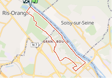
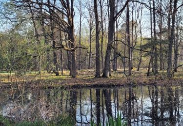
Randonnée Marche de 8,1 km à découvrir à Île-de-France, Essonne, Ris-Orangis. Cette randonnée est proposée par aucamus.

Description

Balisage

Profil altimétrique

Localisation

Pays :
France
Région :
Île-de-France
Département/Province :
Essonne
Commune :
Ris-Orangis
Localité :
Unknown
Départ:(UTM)
457522 ; 5389371 (31U) N.

Randonnées à proximité

Randonnée Marche Juvisy-sur-Orge - GRP CV-IDF 16R Juvisy-sur-Orge à Ballainvilliers - Photo
Marche
clalaur

Marche

Difficile
(1)
Juvisy-sur-Orge, Île-de-France, Essonne, France
14,8 km | 17 km-effort
3h 52min
Non
Randonnée Marche Montgeron - J 38 Montgeron la Pelouse, forêt de Sénart - Photo
Marche

Marche

Difficile
(3)
Montgeron, Île-de-France, Essonne, France
12,4 km | 13,3 km-effort
3h 1min
Oui
Randonnée Marche Montgeron - JC 28 Sénart, Champrosay, Soisy sur Seine - Photo
Marche

Marche

Difficile
(1)
Montgeron, Île-de-France, Essonne, France
21 km | 24 km-effort
5h 21min
Oui
Randonnée Marche Soisy-sur-Seine - Sénart arbres remarquables 1/2 - Photo
Marche
dmatignon

Marche

Facile
(1)
Soisy-sur-Seine, Île-de-France, Essonne, France
12,2 km | 13,1 km-effort
2h 55min
Oui
Randonnée Marche Draveil - Port aux Cerises - Ablon 21 km - Photo
Marche
GUIDE
jeanmarcMasson

Marche

Très difficile
(1)
Draveil, Île-de-France, Essonne, France
22 km | 25 km-effort
4h 51min
Oui
Randonnée Marche Montgeron - 13767736-JVB 10 km - Photo
Marche
GUIDE
jeanmarcMasson

Marche

Moyen
(1)
Montgeron, Île-de-France, Essonne, France
10,3 km | 11,2 km-effort
2h 32min
Oui
Randonnée Marche Montgeron - Parcouurs Sénart journée verte et bleue - Photo
Marche
GUIDE
chessyca

Marche

Très facile
Montgeron, Île-de-France, Essonne, France
16,1 km | 18 km-effort
3h 36min
Oui
Randonnée Marche Brunoy - Boucle Brunoy St Pierre - Tigery 25 km - Photo
Marche
GUIDE
chessyca

Marche

Brunoy, Île-de-France, Essonne, France
25 km | 27 km-effort
6h 53min
Oui
Randonnée V.T.T. Bondoufle - rando
V.T.T.
marsupio

V.T.T.

Facile
(1)
Bondoufle, Île-de-France, Essonne, France
56 km | 63 km-effort
8min
Oui


Fermer
Mes abonnements