![](/images/other/stat-length.png)
![Randonnée Marche Mazamet - mazamet-hautpoul-roquerlan-mazamet - Photo](https://media.geolcdn.com/t/1900/400/ext.pjpeg?maxdim=2&url=https%3A%2F%2Fstatic1.geolcdn.com%2Fsiteimages%2Fupload%2Ffiles%2F1553511878bg_sport_marche.png)
mazamet-hautpoul-roquerlan-mazamet
Dupleix
Utilisateur
![Longueur](/images/other/stat-length.png)
Longueur
22 km
![Altitude max](https://static1.geolcdn.com/siteimages/upload/files/1508320355ic_sort_altitude_max_24dp.png)
Altitude max
785 m
![Dénivelé positif](https://static1.geolcdn.com/siteimages/upload/files/1508320355ic_sort_den_pos_24dp.png)
Dénivelé positif
963 m
![Km-Effort](/images/other/stat-length.png)
Km-Effort
35 km
![Altitude min](https://static1.geolcdn.com/siteimages/upload/files/1508320355ic_sort_altitude_min_24dp.png)
Altitude min
278 m
![Dénivelé négatif](https://static1.geolcdn.com/siteimages/upload/files/1508320355ic_sort_den_neg_24dp.png)
Dénivelé négatif
959 m
![Boucle](https://static1.geolcdn.com/siteimages/upload/files/16400158638029165_repeat_loop_refresh_sync_direction_icon.png)
Boucle
Oui
Date de création :
2019-08-05 16:35:05.653
Dernière modification :
2019-08-05 16:52:38.68
![Marche](https://static1.geolcdn.com/sitytour/trail-icons/101.png)
7h09
Difficulté : Très difficile
![Scannez ce code QR pour ouvrir la randonnée dans l'application SityTrail](https://capi.geolives.com/qq0zvz2zws4bq2lad0pu/sitytour/trails/2161222/qr.png?size=200)
Application GPS de randonnée GRATUITE
À propos
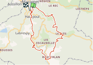
Randonnée Marche de 22 km à découvrir à Occitanie, Tarn, Mazamet. Cette randonnée est proposée par Dupleix.
Description
boucle de 22km partant du parking de la passerelle sortie de la ville sur la d54. Elle passe a hautpoul en prenant la passerelle,le sentier botanique,canjeulieu,roquerlan,les yès,brettes et mazamet.
Localisation
Pays :
France
Région :
Occitanie
Département/Province :
Tarn
Commune :
Mazamet
Localité :
Unknown
Départ:(Dec)
Départ:(UTM)
449534 ; 4814467 (31T) N.
Commentaires
Randonnées à proximité
![Randonnée Marche Mazamet - Mazamet - Hautpoul - Photo](https://media.geolcdn.com/t/375/260/ext.jpg?maxdim=2&url=https%3A%2F%2Fservices.sitytrail.com%2FGeolivesWS%2FDownloadMedia.ashx%3FTrailID%3D118725%26Media%3D12918_6.jpg)
![Marche Marche](https://static1.geolcdn.com/sitytour/trail-icons/101.png)
Mazamet - Hautpoul
Marche
Difficile
(1)
Mazamet,
Occitanie,
Tarn,
France
![](/images/other/stat-length.png)
17,4 km | 29 km-effort
6h 30min
![](https://static1.geolcdn.com/siteimages/upload/files/16400158638029165_repeat_loop_refresh_sync_direction_icon.png)
Oui
![Randonnée Marche Mazamet - Mazamet : chemin de la passerelle - Photo](https://media.geolcdn.com/t/375/260/7fecfe25-55af-4d90-8aa1-4e55b89d75d8.jpg&format=jpg&maxdim=2)
![Marche Marche](https://static1.geolcdn.com/sitytour/trail-icons/101.png)
Mazamet : chemin de la passerelle
Marche
Difficile
Mazamet,
Occitanie,
Tarn,
France
![](/images/other/stat-length.png)
9,6 km | 15,5 km-effort
3h 30min
![](https://static1.geolcdn.com/siteimages/upload/files/16400158638029165_repeat_loop_refresh_sync_direction_icon.png)
Oui
![Randonnée Marche Mazamet - Maeamet la passerelle - Photo](https://media.geolcdn.com/t/375/260/e1724d83-b3f7-4d67-8960-680514083b82.jpg&format=jpg&maxdim=2)
![Marche Marche](https://static1.geolcdn.com/sitytour/trail-icons/101.png)
Maeamet la passerelle
Marche
Moyen
Mazamet,
Occitanie,
Tarn,
France
![](/images/other/stat-length.png)
4,5 km | 8,6 km-effort
1h 32min
![](https://static1.geolcdn.com/siteimages/upload/files/16400158638029165_repeat_loop_refresh_sync_direction_icon.png)
Oui
![Randonnée Marche Mazamet - Passerelle de Mazamet et village médiéval d'Hautpoul - Photo](https://media.geolcdn.com/t/375/260/4633c92a-5ccd-498b-87fe-ea2098cce3e4.jpg&format=jpg&maxdim=2)
![Marche Marche](https://static1.geolcdn.com/sitytour/trail-icons/101.png)
Passerelle de Mazamet et village médiéval d'Hautpoul
Marche
Difficile
Mazamet,
Occitanie,
Tarn,
France
![](/images/other/stat-length.png)
3,2 km | 6,9 km-effort
1h 41min
![](https://static1.geolcdn.com/siteimages/upload/files/16400158638029165_repeat_loop_refresh_sync_direction_icon.png)
Oui
![Randonnée V.T.T. Aussillon - Montagne Noire - Les Montagnès - Photo](https://media.geolcdn.com/t/375/260/ext.jpg?maxdim=2&url=https%3A%2F%2Fstatic1.geolcdn.com%2Fsiteimages%2Fupload%2Ffiles%2F1524743154velo.jpg)
![V.T.T. V.T.T.](https://static1.geolcdn.com/sitytour/trail-icons/202.png)
Montagne Noire - Les Montagnès
V.T.T.
Difficile
(1)
Aussillon,
Occitanie,
Tarn,
France
![](/images/other/stat-length.png)
29 km | 41 km-effort
2h 49min
![](https://static1.geolcdn.com/siteimages/upload/files/16400158638029165_repeat_loop_refresh_sync_direction_icon.png)
Oui
![Randonnée Marche Mazamet - depuis HAUPOULet en 2 boucles - Photo](https://media.geolcdn.com/t/375/260/c65e16d3-923b-4b11-84c0-295b3af471c1.jpg&format=jpg&maxdim=2)
![Marche Marche](https://static1.geolcdn.com/sitytour/trail-icons/101.png)
depuis HAUPOULet en 2 boucles
Marche
Très facile
Mazamet,
Occitanie,
Tarn,
France
![](/images/other/stat-length.png)
14,2 km | 23 km-effort
6h 6min
![](https://static1.geolcdn.com/siteimages/upload/files/16400158638029165_repeat_loop_refresh_sync_direction_icon.png)
Oui
![Randonnée Marche Mazamet - Labrespy, Hautpoul, St-Pierre des Plots - Photo](https://media.geolcdn.com/t/375/260/ext.jpg?maxdim=2&url=https%3A%2F%2Fstatic1.geolcdn.com%2Fsiteimages%2Fupload%2Ffiles%2F1553511878bg_sport_marche.png)
![Marche Marche](https://static1.geolcdn.com/sitytour/trail-icons/101.png)
Labrespy, Hautpoul, St-Pierre des Plots
Marche
Moyen
(1)
Mazamet,
Occitanie,
Tarn,
France
![](/images/other/stat-length.png)
9 km | 13,8 km-effort
3h 1min
![](https://static1.geolcdn.com/siteimages/upload/files/16400158638029165_repeat_loop_refresh_sync_direction_icon.png)
Oui
![Randonnée Marche Mazamet - Labrespy - la Croix de Prat - Photo](https://media.geolcdn.com/t/375/260/ext.jpg?maxdim=2&url=https%3A%2F%2Fstatic1.geolcdn.com%2Fsiteimages%2Fupload%2Ffiles%2F1553511878bg_sport_marche.png)
![Marche Marche](https://static1.geolcdn.com/sitytour/trail-icons/101.png)
Labrespy - la Croix de Prat
Marche
Moyen
(1)
Mazamet,
Occitanie,
Tarn,
France
![](/images/other/stat-length.png)
13,8 km | 21 km-effort
4h 35min
![](https://static1.geolcdn.com/siteimages/upload/files/16400158638029165_repeat_loop_refresh_sync_direction_icon.png)
Oui
![Randonnée V.T.T. Aiguefonde - Balade sur le Causse - Saint Alby - Photo](https://media.geolcdn.com/t/375/260/ext.jpg?maxdim=2&url=https%3A%2F%2Fservices.sitytrail.com%2FGeolivesWS%2FDownloadMedia.ashx%3FTrailID%3D317845%26Media%3D17221_6.jpg)
![V.T.T. V.T.T.](https://static1.geolcdn.com/sitytour/trail-icons/202.png)
Balade sur le Causse - Saint Alby
V.T.T.
Moyen
Aiguefonde,
Occitanie,
Tarn,
France
![](/images/other/stat-length.png)
29 km | 37 km-effort
3h 0min
![](https://static1.geolcdn.com/siteimages/upload/files/16400158638029165_repeat_loop_refresh_sync_direction_icon.png)
Oui