![](/images/other/stat-length.png)
![Randonnée Autre activité Eglisau - Eglisau - Dem Rhein Entlang - Photo](https://media.geolcdn.com/t/1900/400/ext.pjpeg?maxdim=2&url=https%3A%2F%2Fstatic1.geolcdn.com%2Fsiteimages%2Fupload%2Ffiles%2F1545311037marcheuse_200dpi.jpg)
Eglisau - Dem Rhein Entlang
redfam01
Utilisateur
![Longueur](/images/other/stat-length.png)
Longueur
8,8 km
![Altitude max](https://static1.geolcdn.com/siteimages/upload/files/1508320355ic_sort_altitude_max_24dp.png)
Altitude max
390 m
![Dénivelé positif](https://static1.geolcdn.com/siteimages/upload/files/1508320355ic_sort_den_pos_24dp.png)
Dénivelé positif
155 m
![Km-Effort](/images/other/stat-length.png)
Km-Effort
10,9 km
![Altitude min](https://static1.geolcdn.com/siteimages/upload/files/1508320355ic_sort_altitude_min_24dp.png)
Altitude min
337 m
![Dénivelé négatif](https://static1.geolcdn.com/siteimages/upload/files/1508320355ic_sort_den_neg_24dp.png)
Dénivelé négatif
163 m
![Boucle](https://static1.geolcdn.com/siteimages/upload/files/16400158638029165_repeat_loop_refresh_sync_direction_icon.png)
Boucle
Oui
Date de création :
2014-12-11 00:00:00.0
Dernière modification :
2014-12-11 00:00:00.0
![Autre activité](https://static1.geolcdn.com/sitytour/trail-icons/900.png)
--
Difficulté : Inconnu
![Scannez ce code QR pour ouvrir la randonnée dans l'application SityTrail](https://capi.geolives.com/qq0zvz2zws4bq2lad0pu/sitytour/trails/21579/qr.png?size=200)
Application GPS de randonnée GRATUITE
À propos
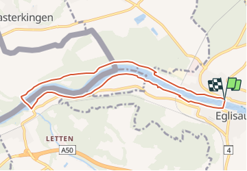
Randonnée Autre activité de 8,8 km à découvrir à Zurich, Bezirk Bülach, Eglisau. Cette randonnée est proposée par redfam01.
Description
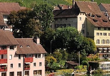
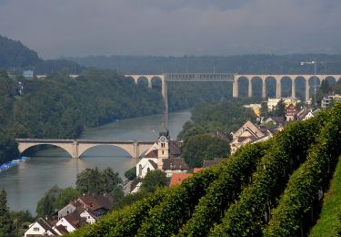
Die Wanderung führt flussabwärts auf der rechten Seite. Vergessen Sie die ID nicht, denn Sie gehen über die Grüne Grenze! Bei Rheinfelden erreichen Sie das Kraftwerk, wo Sie auf die Schweizer Seite wechseln.
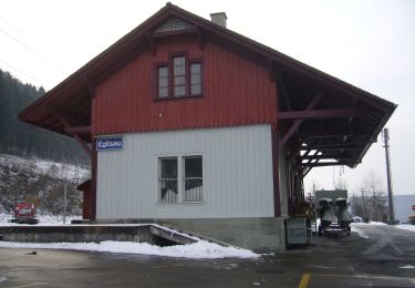
Danach geht es zurück richtung Egliau.
Localisation
Pays :
Suisse
Région :
Zurich
Département/Province :
Bezirk Bülach
Commune :
Eglisau
Localité :
Unknown
Départ:(Dec)
Départ:(UTM)
464053 ; 5269304 (32T) N.
Commentaires
Randonnées à proximité
![Randonnée A pied Berg am Irchel - Irchel Hochwacht - Winterthur - Photo](https://media.geolcdn.com/t/375/260/ext.jpg?maxdim=2&url=https%3A%2F%2Fmedia.geolcdn.com%2Ff%2F9021b627-b640-4c62-a56f-c97534999414.jpeg)
![A pied A pied](https://static1.geolcdn.com/sitytour/trail-icons/100.png)
Irchel Hochwacht - Winterthur
A pied
Moyen
Berg am Irchel,
Zurich,
Bezirk Andelfingen,
Suisse
![](/images/other/stat-length.png)
16,3 km | 20 km-effort
4h 35min
![](https://static1.geolcdn.com/siteimages/upload/files/16400158638029165_repeat_loop_refresh_sync_direction_icon.png)
Non
![Randonnée A pied Rüdlingen - Rüdlingen - Eglisau Bahnhof - Photo](https://media.geolcdn.com/t/375/260/ext.jpg?maxdim=2&url=https%3A%2F%2Fmedia.geolcdn.com%2Ff%2F11928e1e-b873-4037-a2f8-08a87f5da9bf.jpeg)
![A pied A pied](https://static1.geolcdn.com/sitytour/trail-icons/100.png)
Rüdlingen - Eglisau Bahnhof
A pied
Facile
Rüdlingen,
Schaffhouse,
Inconnu,
Suisse
![](/images/other/stat-length.png)
6,3 km | 9,1 km-effort
2h 4min
![](https://static1.geolcdn.com/siteimages/upload/files/16400158638029165_repeat_loop_refresh_sync_direction_icon.png)
Non
![Randonnée A pied Rüdlingen - Rüdlingen - Ellikon am Rhein - Photo](https://media.geolcdn.com/t/375/260/ext.jpg?maxdim=2&url=https%3A%2F%2Fmedia.geolcdn.com%2Ff%2F25c4e05d-745d-4279-a6b0-ba809d7600a9.jpeg)
![A pied A pied](https://static1.geolcdn.com/sitytour/trail-icons/100.png)
Rüdlingen - Ellikon am Rhein
A pied
Facile
Rüdlingen,
Schaffhouse,
Inconnu,
Suisse
![](/images/other/stat-length.png)
4,2 km | 4,7 km-effort
1h 4min
![](https://static1.geolcdn.com/siteimages/upload/files/16400158638029165_repeat_loop_refresh_sync_direction_icon.png)
Non
![Randonnée A pied Rafz - Rafz - Eglisau Bahnhof - Photo](https://media.geolcdn.com/t/375/260/ext.jpg?maxdim=2&url=https%3A%2F%2Fmedia.geolcdn.com%2Ff%2Fdb32595a-b7f7-4371-b947-c2ac8504042d.jpeg)
![A pied A pied](https://static1.geolcdn.com/sitytour/trail-icons/100.png)
Rafz - Eglisau Bahnhof
A pied
Facile
Rafz,
Zurich,
Bezirk Bülach,
Suisse
![](/images/other/stat-length.png)
5,4 km | 6,3 km-effort
1h 26min
![](https://static1.geolcdn.com/siteimages/upload/files/16400158638029165_repeat_loop_refresh_sync_direction_icon.png)
Non
![Randonnée A pied Eglisau - Eglisau Bahnhof - Rüdlingen - Photo](https://media.geolcdn.com/t/375/260/ext.jpg?maxdim=2&url=https%3A%2F%2Fmedia.geolcdn.com%2Ff%2F11928e1e-b873-4037-a2f8-08a87f5da9bf.jpeg)
![A pied A pied](https://static1.geolcdn.com/sitytour/trail-icons/100.png)
Eglisau Bahnhof - Rüdlingen
A pied
Facile
Eglisau,
Zurich,
Bezirk Bülach,
Suisse
![](/images/other/stat-length.png)
6 km | 8,1 km-effort
1h 50min
![](https://static1.geolcdn.com/siteimages/upload/files/16400158638029165_repeat_loop_refresh_sync_direction_icon.png)
Non
![Randonnée A pied Flaach - Scheublisallmend - Thurhof - Photo](https://media.geolcdn.com/t/375/260/ext.jpg?maxdim=2&url=https%3A%2F%2Fmedia.geolcdn.com%2Ff%2Fdaccca04-78af-4d11-ac2d-cc1fe3034220.jpeg)
![A pied A pied](https://static1.geolcdn.com/sitytour/trail-icons/100.png)
Scheublisallmend - Thurhof
A pied
Facile
Flaach,
Zurich,
Bezirk Andelfingen,
Suisse
![](/images/other/stat-length.png)
3,1 km | 3,5 km-effort
48min
![](https://static1.geolcdn.com/siteimages/upload/files/16400158638029165_repeat_loop_refresh_sync_direction_icon.png)
Non
![Randonnée A pied Eglisau - Eglisau Bahnhof - Winterthur - Photo](https://media.geolcdn.com/t/375/260/ext.jpg?maxdim=2&url=https%3A%2F%2Fmedia.geolcdn.com%2Ff%2F90ecdb9f-56be-4fc0-a521-33a498f72cf2.jpeg)
![A pied A pied](https://static1.geolcdn.com/sitytour/trail-icons/100.png)
Eglisau Bahnhof - Winterthur
A pied
Moyen
Eglisau,
Zurich,
Bezirk Bülach,
Suisse
![](/images/other/stat-length.png)
24 km | 29 km-effort
6h 40min
![](https://static1.geolcdn.com/siteimages/upload/files/16400158638029165_repeat_loop_refresh_sync_direction_icon.png)
Non
![Randonnée A pied Eglisau - Eglisau Bahnhof - Tössegg Schiffsteg - Photo](https://media.geolcdn.com/t/375/260/ext.jpg?maxdim=2&url=https%3A%2F%2Fmedia.geolcdn.com%2Ff%2Fde0dcb80-949d-4896-aade-9c2e074405fd.jpeg)
![A pied A pied](https://static1.geolcdn.com/sitytour/trail-icons/100.png)
Eglisau Bahnhof - Tössegg Schiffsteg
A pied
Facile
Eglisau,
Zurich,
Bezirk Bülach,
Suisse
![](/images/other/stat-length.png)
4,6 km | 5,3 km-effort
1h 12min
![](https://static1.geolcdn.com/siteimages/upload/files/16400158638029165_repeat_loop_refresh_sync_direction_icon.png)
Non
![Randonnée A pied Eglisau - Eglisau Bahnhof - Tössriederen - Photo](https://media.geolcdn.com/t/375/260/ext.jpg?maxdim=2&url=https%3A%2F%2Fmedia.geolcdn.com%2Ff%2Fdb32595a-b7f7-4371-b947-c2ac8504042d.jpeg)
![A pied A pied](https://static1.geolcdn.com/sitytour/trail-icons/100.png)
Eglisau Bahnhof - Tössriederen
A pied
Facile
Eglisau,
Zurich,
Bezirk Bülach,
Suisse
![](/images/other/stat-length.png)
3 km | 3,4 km-effort
45min
![](https://static1.geolcdn.com/siteimages/upload/files/16400158638029165_repeat_loop_refresh_sync_direction_icon.png)
Non