![](/images/other/stat-length.png)
![Randonnée Autre activité Altstätten - Hoher Kasten - Bollenwees- Brülisau - Photo](https://media.geolcdn.com/t/1900/400/ext.pjpeg?maxdim=2&url=https%3A%2F%2Fstatic1.geolcdn.com%2Fsiteimages%2Fupload%2Ffiles%2F1545311037marcheuse_200dpi.jpg)
Hoher Kasten - Bollenwees- Brülisau
redfam01
Utilisateur
![Longueur](/images/other/stat-length.png)
Longueur
14,7 km
![Altitude max](https://static1.geolcdn.com/siteimages/upload/files/1508320355ic_sort_altitude_max_24dp.png)
Altitude max
1807 m
![Dénivelé positif](https://static1.geolcdn.com/siteimages/upload/files/1508320355ic_sort_den_pos_24dp.png)
Dénivelé positif
537 m
![Km-Effort](/images/other/stat-length.png)
Km-Effort
24 km
![Altitude min](https://static1.geolcdn.com/siteimages/upload/files/1508320355ic_sort_altitude_min_24dp.png)
Altitude min
924 m
![Dénivelé négatif](https://static1.geolcdn.com/siteimages/upload/files/1508320355ic_sort_den_neg_24dp.png)
Dénivelé négatif
1291 m
![Boucle](https://static1.geolcdn.com/siteimages/upload/files/16400158638029165_repeat_loop_refresh_sync_direction_icon.png)
Boucle
Non
Date de création :
2014-12-11 00:00:00.0
Dernière modification :
2014-12-11 00:00:00.0
![Autre activité](https://static1.geolcdn.com/sitytour/trail-icons/900.png)
--
Difficulté : Inconnu
![Scannez ce code QR pour ouvrir la randonnée dans l'application SityTrail](https://capi.geolives.com/qq0zvz2zws4bq2lad0pu/sitytour/trails/21578/qr.png?size=200)
Application GPS de randonnée GRATUITE
À propos
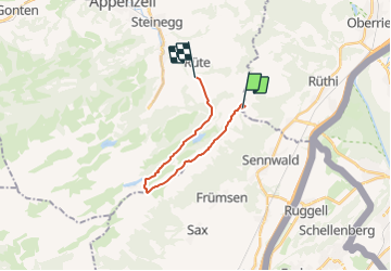
Randonnée Autre activité de 14,7 km à découvrir à Saint-Gall, Wahlkreis Rheintal, Altstätten. Cette randonnée est proposée par redfam01.
Description
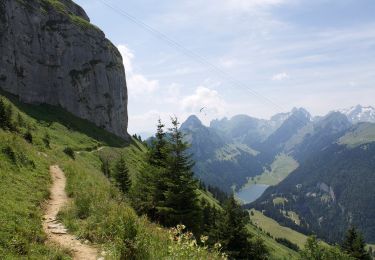
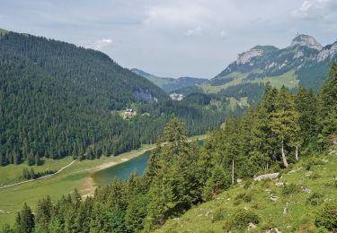
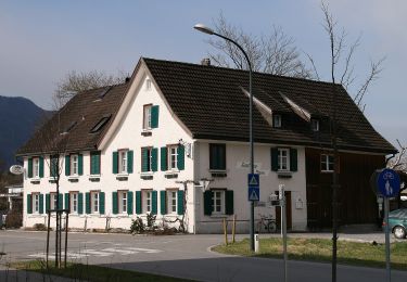
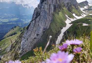
Vom Hohen Kasten aus führt die Wanderung zur Stauberen (Verpflegungsmöglichkeit). Im Restaurant Bollenwees sollte man unbedingt eine der feinen Röstis probieren, bevor man den Abstieg nach Brülisau unter die Beine nimmt.
Localisation
Pays :
Suisse
Région :
Saint-Gall
Département/Province :
Wahlkreis Rheintal
Commune :
Altstätten
Localité :
Unknown
Départ:(Dec)
Départ:(UTM)
536727 ; 5236816 (32T) N.
Commentaires
Randonnées à proximité
![Randonnée A pied Stadt Feldkirch - Dreiländerweg - BeWegung Begegnung - Photo](https://media.geolcdn.com/t/375/260/44257ac4-db4b-49c2-80b9-b6bc6b4bc691.jpeg&format=jpg&maxdim=2)
![A pied A pied](https://static1.geolcdn.com/sitytour/trail-icons/100.png)
Dreiländerweg - BeWegung Begegnung
A pied
Facile
Stadt Feldkirch,
Vorarlberg,
Bezirk Feldkirch,
Autriche
![](/images/other/stat-length.png)
5,5 km | 6,2 km-effort
1h 23min
![](https://static1.geolcdn.com/siteimages/upload/files/16400158638029165_repeat_loop_refresh_sync_direction_icon.png)
Non
![Randonnée A pied Rüte - Ruhsitz - Rainhütte - Photo](https://media.geolcdn.com/t/375/260/dev_47fa53f7-ab8b-475b-88af-4674e0dc9e97.jpeg&format=jpg&maxdim=2)
![A pied A pied](https://static1.geolcdn.com/sitytour/trail-icons/100.png)
Ruhsitz - Rainhütte
A pied
Facile
Rüte,
Appenzell Rhodes-Intérieures,
Inconnu,
Suisse
![](/images/other/stat-length.png)
4,7 km | 7 km-effort
1h 35min
![](https://static1.geolcdn.com/siteimages/upload/files/16400158638029165_repeat_loop_refresh_sync_direction_icon.png)
Non
![Randonnée A pied Schwende - Klein-Hütten - Meglisalp - Photo](https://media.geolcdn.com/t/375/260/961051f3-9cab-4040-8a27-2c04632945d2.jpeg&format=jpg&maxdim=2)
![A pied A pied](https://static1.geolcdn.com/sitytour/trail-icons/100.png)
Klein-Hütten - Meglisalp
A pied
Facile
Schwende,
Appenzell Rhodes-Intérieures,
Inconnu,
Suisse
![](/images/other/stat-length.png)
4,1 km | 8,6 km-effort
1h 57min
![](https://static1.geolcdn.com/siteimages/upload/files/16400158638029165_repeat_loop_refresh_sync_direction_icon.png)
Non
![Randonnée A pied Rüte - Staubern-Kastensattel - Photo](https://media.geolcdn.com/t/375/260/dev_1ac482fc-76df-4fc6-a8e7-04f8b73b33cd.jpeg&format=jpg&maxdim=2)
![A pied A pied](https://static1.geolcdn.com/sitytour/trail-icons/100.png)
Staubern-Kastensattel
A pied
Facile
Rüte,
Appenzell Rhodes-Intérieures,
Inconnu,
Suisse
![](/images/other/stat-length.png)
4,3 km | 7,8 km-effort
1h 45min
![](https://static1.geolcdn.com/siteimages/upload/files/16400158638029165_repeat_loop_refresh_sync_direction_icon.png)
Non
![Randonnée A pied Rüte - Brülisau-Bollenwees - Photo](https://media.geolcdn.com/t/375/260/383b46a9-6255-45bf-ad89-e6a7ed6cf110.jpeg&format=jpg&maxdim=2)
![A pied A pied](https://static1.geolcdn.com/sitytour/trail-icons/100.png)
Brülisau-Bollenwees
A pied
Facile
Rüte,
Appenzell Rhodes-Intérieures,
Inconnu,
Suisse
![](/images/other/stat-length.png)
5,7 km | 12 km-effort
2h 44min
![](https://static1.geolcdn.com/siteimages/upload/files/16400158638029165_repeat_loop_refresh_sync_direction_icon.png)
Non
![Randonnée A pied Stadt Feldkirch - Bangs (A) - Ruggell - Photo](https://media.geolcdn.com/t/375/260/7b7484f0-645e-46b4-a9b5-c16c698cb122.jpeg&format=jpg&maxdim=2)
![A pied A pied](https://static1.geolcdn.com/sitytour/trail-icons/100.png)
Bangs (A) - Ruggell
A pied
Facile
Stadt Feldkirch,
Vorarlberg,
Bezirk Feldkirch,
Autriche
![](/images/other/stat-length.png)
4,9 km | 5,3 km-effort
1h 12min
![](https://static1.geolcdn.com/siteimages/upload/files/16400158638029165_repeat_loop_refresh_sync_direction_icon.png)
Non
![Randonnée A pied Sennwald - Staubern - Saxerlücke - Photo](https://media.geolcdn.com/t/375/260/493eb28d-020f-4153-ae7d-a831c3a32d0d.jpeg&format=jpg&maxdim=2)
![A pied A pied](https://static1.geolcdn.com/sitytour/trail-icons/100.png)
Staubern - Saxerlücke
A pied
Facile
Sennwald,
Saint-Gall,
Wahlkreis Werdenberg,
Suisse
![](/images/other/stat-length.png)
3,2 km | 5,7 km-effort
1h 18min
![](https://static1.geolcdn.com/siteimages/upload/files/16400158638029165_repeat_loop_refresh_sync_direction_icon.png)
Non
![Randonnée Autre activité Rüte - sf10_e1a - Photo](https://media.geolcdn.com/t/375/260/ext.jpg?maxdim=2&url=https%3A%2F%2Fstatic1.geolcdn.com%2Fsiteimages%2Fupload%2Ffiles%2F1545311037marcheuse_200dpi.jpg)
![Autre activité Autre activité](https://static1.geolcdn.com/sitytour/trail-icons/900.png)
sf10_e1a
Autre activité
Très facile
Rüte,
Appenzell Rhodes-Intérieures,
Inconnu,
Suisse
![](/images/other/stat-length.png)
28 km | 46 km-effort
10h 14min
![](https://static1.geolcdn.com/siteimages/upload/files/16400158638029165_repeat_loop_refresh_sync_direction_icon.png)
Non
![Randonnée Marche Schwende - hike23 - Photo](https://media.geolcdn.com/t/375/260/ext.jpg?maxdim=2&url=https%3A%2F%2Fstatic1.geolcdn.com%2Fsiteimages%2Fupload%2Ffiles%2F1553511878bg_sport_marche.png)
![Marche Marche](https://static1.geolcdn.com/sitytour/trail-icons/101.png)
hike23
Marche
Très facile
Schwende,
Appenzell Rhodes-Intérieures,
Inconnu,
Suisse
![](/images/other/stat-length.png)
7,2 km | 16,3 km-effort
Inconnu
![](https://static1.geolcdn.com/siteimages/upload/files/16400158638029165_repeat_loop_refresh_sync_direction_icon.png)
Non