![](/images/other/stat-length.png)
![Randonnée V.T.T. Audun-le-Tiche - La frontière / Audun - Hussigny - Photo](https://media.geolcdn.com/t/1900/400/ext.pjpeg?maxdim=2&url=https%3A%2F%2Fstatic1.geolcdn.com%2Fsiteimages%2Fupload%2Ffiles%2F1524743154velo.jpg)
La frontière / Audun - Hussigny
Greg813
Utilisateur
![Longueur](/images/other/stat-length.png)
Longueur
27 km
![Altitude max](https://static1.geolcdn.com/siteimages/upload/files/1508320355ic_sort_altitude_max_24dp.png)
Altitude max
437 m
![Dénivelé positif](https://static1.geolcdn.com/siteimages/upload/files/1508320355ic_sort_den_pos_24dp.png)
Dénivelé positif
437 m
![Km-Effort](/images/other/stat-length.png)
Km-Effort
33 km
![Altitude min](https://static1.geolcdn.com/siteimages/upload/files/1508320355ic_sort_altitude_min_24dp.png)
Altitude min
298 m
![Dénivelé négatif](https://static1.geolcdn.com/siteimages/upload/files/1508320355ic_sort_den_neg_24dp.png)
Dénivelé négatif
438 m
![Boucle](https://static1.geolcdn.com/siteimages/upload/files/16400158638029165_repeat_loop_refresh_sync_direction_icon.png)
Boucle
Oui
Date de création :
2019-08-01 12:39:00.812
Dernière modification :
2019-08-02 08:48:53.044
![V.T.T.](https://static1.geolcdn.com/sitytour/trail-icons/202.png)
3h18
Difficulté : Difficile
![Scannez ce code QR pour ouvrir la randonnée dans l'application SityTrail](https://capi.geolives.com/qq0zvz2zws4bq2lad0pu/sitytour/trails/2156709/qr.png?size=200)
Application GPS de randonnée GRATUITE
À propos
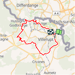
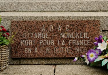
Randonnée V.T.T. de 27 km à découvrir à Grand Est, Moselle, Audun-le-Tiche. Cette randonnée est proposée par Greg813.
Description
Randonné obligatoirement en VTT idéale pour faire travailler le cardio. En grande majorité ombragée, le passage le long des fortifications de la ligne Maginot vaut les efforts !
Localisation
Pays :
France
Région :
Grand Est
Département/Province :
Moselle
Commune :
Audun-le-Tiche
Localité :
Unknown
Départ:(Dec)
Départ:(UTM)
713978 ; 5483882 (31U) N.
Commentaires
Randonnées à proximité
![Randonnée A pied Esch-sur-Alzette - Sentier Pierre Wiess - Photo](https://media.geolcdn.com/t/375/260/fb7503a0-8edc-4589-a05b-6ac952d1b3b6.jpeg&format=jpg&maxdim=2)
![A pied A pied](https://static1.geolcdn.com/sitytour/trail-icons/100.png)
Sentier Pierre Wiess
A pied
Facile
Esch-sur-Alzette,
Inconnu,
Canton Esch-sur-Alzette,
Luxembourg
![](/images/other/stat-length.png)
3,9 km | 5,4 km-effort
1h 14min
![](https://static1.geolcdn.com/siteimages/upload/files/16400158638029165_repeat_loop_refresh_sync_direction_icon.png)
Non
![Randonnée A pied Schifflange - Auto-Pédestre Schifflange - Photo](https://media.geolcdn.com/t/375/260/6e4f4de8-0f99-4558-801f-ac0feb96d3b3.jpeg&format=jpg&maxdim=2)
![A pied A pied](https://static1.geolcdn.com/sitytour/trail-icons/100.png)
Auto-Pédestre Schifflange
A pied
Facile
Schifflange,
Inconnu,
Canton Esch-sur-Alzette,
Luxembourg
![](/images/other/stat-length.png)
7,8 km | 10,5 km-effort
2h 23min
![](https://static1.geolcdn.com/siteimages/upload/files/16400158638029165_repeat_loop_refresh_sync_direction_icon.png)
Oui
![Randonnée A pied Esch-sur-Alzette - Auto-Pédestre Esch-sur-Alzette - Photo](https://media.geolcdn.com/t/375/260/b5c02b78-1f2a-4286-8a45-2a22bbfe4d56.jpeg&format=jpg&maxdim=2)
![A pied A pied](https://static1.geolcdn.com/sitytour/trail-icons/100.png)
Auto-Pédestre Esch-sur-Alzette
A pied
Facile
(1)
Esch-sur-Alzette,
Inconnu,
Canton Esch-sur-Alzette,
Luxembourg
![](/images/other/stat-length.png)
7,2 km | 9,8 km-effort
2h 13min
![](https://static1.geolcdn.com/siteimages/upload/files/16400158638029165_repeat_loop_refresh_sync_direction_icon.png)
Oui
![Randonnée A pied Kayl - Auto-Pédestre Kayl - Photo](https://media.geolcdn.com/t/375/260/05634cbd-69a7-4685-a005-dc48af1d3e5c.jpeg&format=jpg&maxdim=2)
![A pied A pied](https://static1.geolcdn.com/sitytour/trail-icons/100.png)
Auto-Pédestre Kayl
A pied
Facile
Kayl,
Inconnu,
Canton Esch-sur-Alzette,
Luxembourg
![](/images/other/stat-length.png)
5,9 km | 7,6 km-effort
1h 43min
![](https://static1.geolcdn.com/siteimages/upload/files/16400158638029165_repeat_loop_refresh_sync_direction_icon.png)
Oui
![Randonnée V.T.T. Audun-le-Tiche - la randodunoise 2010 - Photo](https://media.geolcdn.com/t/375/260/ext.jpg?maxdim=2&url=https%3A%2F%2Fstatic1.geolcdn.com%2Fsiteimages%2Fupload%2Ffiles%2F1524743154velo.jpg)
![V.T.T. V.T.T.](https://static1.geolcdn.com/sitytour/trail-icons/202.png)
la randodunoise 2010
V.T.T.
Très facile
(1)
Audun-le-Tiche,
Grand Est,
Moselle,
France
![](/images/other/stat-length.png)
38 km | 48 km-effort
Inconnu
![](https://static1.geolcdn.com/siteimages/upload/files/16400158638029165_repeat_loop_refresh_sync_direction_icon.png)
Non
![Randonnée A pied Ottange - Boucle d'Ottange - Photo](https://media.geolcdn.com/t/375/260/4f81de2e-9288-4ceb-9209-2e12554d6d66.jpeg&format=jpg&maxdim=2)
![A pied A pied](https://static1.geolcdn.com/sitytour/trail-icons/100.png)
Boucle d'Ottange
A pied
Facile
Ottange,
Grand Est,
Moselle,
France
![](/images/other/stat-length.png)
4,1 km | 5,5 km-effort
1h 14min
![](https://static1.geolcdn.com/siteimages/upload/files/16400158638029165_repeat_loop_refresh_sync_direction_icon.png)
Oui
![Randonnée A pied Rédange - Boucle de Rédange - Photo](https://media.geolcdn.com/t/375/260/f050ebd0-ef73-4e7b-9c2b-78da25f4d2eb.jpeg&format=jpg&maxdim=2)
![A pied A pied](https://static1.geolcdn.com/sitytour/trail-icons/100.png)
Boucle de Rédange
A pied
Facile
Rédange,
Grand Est,
Moselle,
France
![](/images/other/stat-length.png)
4,6 km | 5,4 km-effort
1h 14min
![](https://static1.geolcdn.com/siteimages/upload/files/16400158638029165_repeat_loop_refresh_sync_direction_icon.png)
Non
![Randonnée A pied Ottange - Ottange Circuit Schmettebusch - Photo](https://media.geolcdn.com/t/375/260/e03ec25f-1ced-4014-8b11-d9cfd2f098ff.jpeg&format=jpg&maxdim=2)
![A pied A pied](https://static1.geolcdn.com/sitytour/trail-icons/100.png)
Ottange Circuit Schmettebusch
A pied
Facile
Ottange,
Grand Est,
Moselle,
France
![](/images/other/stat-length.png)
5,7 km | 7,9 km-effort
1h 47min
![](https://static1.geolcdn.com/siteimages/upload/files/16400158638029165_repeat_loop_refresh_sync_direction_icon.png)
Non
![Randonnée A pied Esch-sur-Alzette - Promenade Architecturale - Photo](https://media.geolcdn.com/t/375/260/fc1c5986-5145-4464-8347-1dd156f13990.jpeg&format=jpg&maxdim=2)
![A pied A pied](https://static1.geolcdn.com/sitytour/trail-icons/100.png)
Promenade Architecturale
A pied
Facile
Esch-sur-Alzette,
Inconnu,
Canton Esch-sur-Alzette,
Luxembourg
![](/images/other/stat-length.png)
4 km | 4,3 km-effort
58min
![](https://static1.geolcdn.com/siteimages/upload/files/16400158638029165_repeat_loop_refresh_sync_direction_icon.png)
Oui