![](/images/other/stat-length.png)
![Randonnée Marche La Motte-Chalancon - lac du pas des ondes-la motte chaloncon - Photo](https://media.geolcdn.com/t/1900/400/ext.pjpeg?maxdim=2&url=https%3A%2F%2Fservices.sitytrail.com%2FGeolivesWS%2FDownloadMedia.ashx%3FTrailID%3D215403%26Media%3D20130820172336.jpg)
lac du pas des ondes-la motte chaloncon
guariso
Utilisateur
![Longueur](/images/other/stat-length.png)
Longueur
5,7 km
![Altitude max](https://static1.geolcdn.com/siteimages/upload/files/1508320355ic_sort_altitude_max_24dp.png)
Altitude max
617 m
![Dénivelé positif](https://static1.geolcdn.com/siteimages/upload/files/1508320355ic_sort_den_pos_24dp.png)
Dénivelé positif
107 m
![Km-Effort](/images/other/stat-length.png)
Km-Effort
7,1 km
![Altitude min](https://static1.geolcdn.com/siteimages/upload/files/1508320355ic_sort_altitude_min_24dp.png)
Altitude min
515 m
![Dénivelé négatif](https://static1.geolcdn.com/siteimages/upload/files/1508320355ic_sort_den_neg_24dp.png)
Dénivelé négatif
104 m
![Boucle](https://static1.geolcdn.com/siteimages/upload/files/16400158638029165_repeat_loop_refresh_sync_direction_icon.png)
Boucle
Oui
Date de création :
2014-12-10 00:00:00.0
Dernière modification :
2014-12-10 00:00:00.0
![Marche](https://static1.geolcdn.com/sitytour/trail-icons/101.png)
2h25
Difficulté : Facile
![Scannez ce code QR pour ouvrir la randonnée dans l'application SityTrail](https://capi.geolives.com/qq0zvz2zws4bq2lad0pu/sitytour/trails/215403/qr.png?size=200)
Application GPS de randonnée GRATUITE
À propos
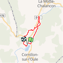
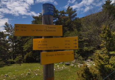
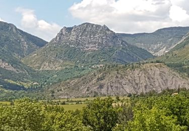
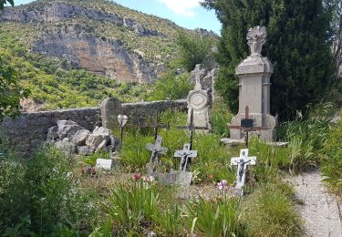
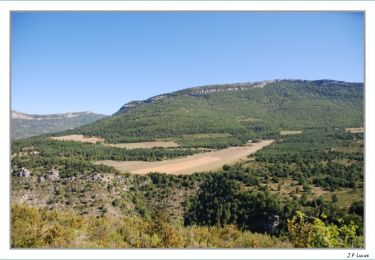
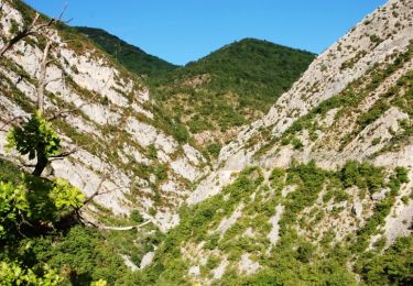
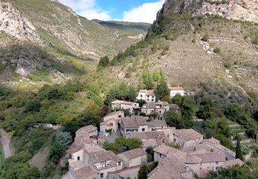
Randonnée Marche de 5,7 km à découvrir à Auvergne-Rhône-Alpes, Drôme, La Motte-Chalancon. Cette randonnée est proposée par guariso.
Description
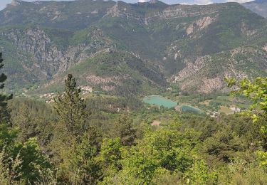
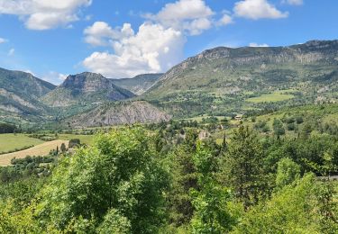
Petite balade dans la vallee de l'oule pres du plan d'eau. Faite avec deux octogenaires mais descente delicate. Denivele de 130m. Sitytrail ne calcule pas bien.
Localisation
Pays :
France
Région :
Auvergne-Rhône-Alpes
Département/Province :
Drôme
Commune :
La Motte-Chalancon
Localité :
Unknown
Départ:(Dec)
Départ:(UTM)
688220 ; 4926200 (31T) N.
Commentaires
Randonnées à proximité
![Randonnée Marche La Motte-Chalancon - Boucle à Cornillon - Photo](https://media.geolcdn.com/t/375/260/ext.jpg?maxdim=2&url=https%3A%2F%2Fmedia.geolcdn.com%2Ff%2F68e11cbc-3244-4d5b-8d24-31101eb609ab.jpg)
![Marche Marche](https://static1.geolcdn.com/sitytour/trail-icons/101.png)
Boucle à Cornillon
Marche
Moyen
(1)
La Motte-Chalancon,
Auvergne-Rhône-Alpes,
Drôme,
France
![](/images/other/stat-length.png)
10,7 km | 16,9 km-effort
3h 34min
![](https://static1.geolcdn.com/siteimages/upload/files/16400158638029165_repeat_loop_refresh_sync_direction_icon.png)
Oui
![Randonnée Marche La Motte-Chalancon - La Motte Chalancon - Plateau de la Chau - Photo](https://media.geolcdn.com/t/375/260/ext.jpg?maxdim=2&url=https%3A%2F%2Fmedia.geolcdn.com%2Ff%2F5f397974-316e-44d5-952e-803b0bd6736b.jpg)
![Marche Marche](https://static1.geolcdn.com/sitytour/trail-icons/101.png)
La Motte Chalancon - Plateau de la Chau
Marche
Moyen
(1)
La Motte-Chalancon,
Auvergne-Rhône-Alpes,
Drôme,
France
![](/images/other/stat-length.png)
8,8 km | 14,6 km-effort
8h 5min
![](https://static1.geolcdn.com/siteimages/upload/files/16400158638029165_repeat_loop_refresh_sync_direction_icon.png)
Oui
![Randonnée Marche La Motte-Chalancon - LA MOTTE CHALANCON - LE PLATEAU DE LA CHAU - Photo](https://media.geolcdn.com/t/375/260/ext.jpg?maxdim=2&url=https%3A%2F%2Fmedia.geolcdn.com%2Ff%2F4f26d25d-f819-4267-a4ac-87b7f19efa5f.jpg)
![Marche Marche](https://static1.geolcdn.com/sitytour/trail-icons/101.png)
LA MOTTE CHALANCON - LE PLATEAU DE LA CHAU
Marche
Moyen
La Motte-Chalancon,
Auvergne-Rhône-Alpes,
Drôme,
France
![](/images/other/stat-length.png)
9,1 km | 14,9 km-effort
7h 30min
![](https://static1.geolcdn.com/siteimages/upload/files/16400158638029165_repeat_loop_refresh_sync_direction_icon.png)
Oui
![Randonnée Marche Saint-May - SAINT MAY - BOUCLE PLATEAU SAINT LAURENT - Photo](https://media.geolcdn.com/t/375/260/ext.jpg?maxdim=2&url=https%3A%2F%2Fmedia.geolcdn.com%2Ff%2Fc55551b7-f4ab-413a-bd71-f91afc892db7.jpg)
![Marche Marche](https://static1.geolcdn.com/sitytour/trail-icons/101.png)
SAINT MAY - BOUCLE PLATEAU SAINT LAURENT
Marche
Moyen
Saint-May,
Auvergne-Rhône-Alpes,
Drôme,
France
![](/images/other/stat-length.png)
10,3 km | 16,5 km-effort
6h 33min
![](https://static1.geolcdn.com/siteimages/upload/files/16400158638029165_repeat_loop_refresh_sync_direction_icon.png)
Oui
![Randonnée Marche Chalancon - 26 eyriau - Photo](https://media.geolcdn.com/t/375/260/ext.jpg?maxdim=2&url=https%3A%2F%2Fmedia.geolcdn.com%2Ff%2F7f70cd36-a3d0-48cb-b54c-083b90637d61.jpg)
![Marche Marche](https://static1.geolcdn.com/sitytour/trail-icons/101.png)
26 eyriau
Marche
Moyen
Chalancon,
Auvergne-Rhône-Alpes,
Drôme,
France
![](/images/other/stat-length.png)
14,7 km | 27 km-effort
6h 57min
![](https://static1.geolcdn.com/siteimages/upload/files/16400158638029165_repeat_loop_refresh_sync_direction_icon.png)
Oui
![Randonnée Cheval La Motte-Chalancon - DIOIS 3J J2 1605 - Photo](https://media.geolcdn.com/t/375/260/ext.jpg?maxdim=2&url=https%3A%2F%2Fstatic1.geolcdn.com%2Fsiteimages%2Fupload%2Ffiles%2F1524743154cheval.jpg)
![Cheval Cheval](https://static1.geolcdn.com/sitytour/trail-icons/300.png)
DIOIS 3J J2 1605
Cheval
Moyen
(1)
La Motte-Chalancon,
Auvergne-Rhône-Alpes,
Drôme,
France
![](/images/other/stat-length.png)
28 km | 45 km-effort
5h 24min
![](https://static1.geolcdn.com/siteimages/upload/files/16400158638029165_repeat_loop_refresh_sync_direction_icon.png)
Non
![Randonnée Marche La Motte-Chalancon - Motte - Vieille - La Motte Chalancon - Photo](https://media.geolcdn.com/t/375/260/ext.jpg?maxdim=2&url=https%3A%2F%2Fservices.sitytrail.com%2FGeolivesWS%2FDownloadMedia.ashx%3FTrailID%3D106200%26Media%3D10491_4.jpg)
![Marche Marche](https://static1.geolcdn.com/sitytour/trail-icons/101.png)
Motte - Vieille - La Motte Chalancon
Marche
Moyen
La Motte-Chalancon,
Auvergne-Rhône-Alpes,
Drôme,
France
![](/images/other/stat-length.png)
6,7 km | 11 km-effort
2h 30min
![](https://static1.geolcdn.com/siteimages/upload/files/16400158638029165_repeat_loop_refresh_sync_direction_icon.png)
Non
![Randonnée Marche Arnayon - Chamousset - Photo](https://media.geolcdn.com/t/375/260/ext.jpg?maxdim=2&url=https%3A%2F%2Fservices.sitytrail.com%2FGeolivesWS%2FDownloadMedia.ashx%3FTrailID%3D104451%26Media%3D7704_6.jpg)
![Marche Marche](https://static1.geolcdn.com/sitytour/trail-icons/101.png)
Chamousset
Marche
Moyen
Arnayon,
Auvergne-Rhône-Alpes,
Drôme,
France
![](/images/other/stat-length.png)
5,9 km | 9 km-effort
2h 30min
![](https://static1.geolcdn.com/siteimages/upload/files/16400158638029165_repeat_loop_refresh_sync_direction_icon.png)
Oui
![Randonnée Marche Saint-May - st may - Photo](https://media.geolcdn.com/t/375/260/ext.jpg?maxdim=2&url=https%3A%2F%2Fmedia.geolcdn.com%2Ff%2F0528f846-6f5f-493b-b9eb-8a54aad9a035.jpg)
![Marche Marche](https://static1.geolcdn.com/sitytour/trail-icons/101.png)
st may
Marche
Moyen
Saint-May,
Auvergne-Rhône-Alpes,
Drôme,
France
![](/images/other/stat-length.png)
10,4 km | 17,1 km-effort
4h 19min
![](https://static1.geolcdn.com/siteimages/upload/files/16400158638029165_repeat_loop_refresh_sync_direction_icon.png)
Oui