![](/images/other/stat-length.png)
![Randonnée Vélo Chambord - De Beaugency à Chambord - Photo](https://media.geolcdn.com/t/1900/400/ext.pjpeg?maxdim=2&url=https%3A%2F%2Fservices.sitytrail.com%2FGeolivesWS%2FDownloadMedia.ashx%3FTrailID%3D215195%26Media%3D15800_2.jpg)
De Beaugency à Chambord
tracegps
Utilisateur
![Longueur](/images/other/stat-length.png)
Longueur
28 km
![Altitude max](https://static1.geolcdn.com/siteimages/upload/files/1508320355ic_sort_altitude_max_24dp.png)
Altitude max
109 m
![Dénivelé positif](https://static1.geolcdn.com/siteimages/upload/files/1508320355ic_sort_den_pos_24dp.png)
Dénivelé positif
224 m
![Km-Effort](/images/other/stat-length.png)
Km-Effort
31 km
![Altitude min](https://static1.geolcdn.com/siteimages/upload/files/1508320355ic_sort_altitude_min_24dp.png)
Altitude min
70 m
![Dénivelé négatif](https://static1.geolcdn.com/siteimages/upload/files/1508320355ic_sort_den_neg_24dp.png)
Dénivelé négatif
197 m
![Boucle](https://static1.geolcdn.com/siteimages/upload/files/16400158638029165_repeat_loop_refresh_sync_direction_icon.png)
Boucle
Non
Date de création :
2014-12-10 00:00:00.0
Dernière modification :
2014-12-10 00:00:00.0
![Vélo](https://static1.geolcdn.com/sitytour/trail-icons/200.png)
1h49
Difficulté : Facile
![Scannez ce code QR pour ouvrir la randonnée dans l'application SityTrail](https://capi.geolives.com/qq0zvz2zws4bq2lad0pu/sitytour/trails/215195/qr.png?size=200)
Application GPS de randonnée GRATUITE
À propos
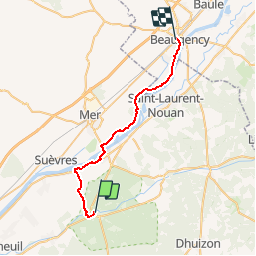
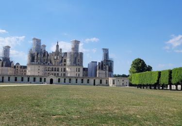
Randonnée Vélo de 28 km à découvrir à Centre-Val de Loire, Loir-et-Cher, Chambord. Cette randonnée est proposée par tracegps.
Description
Une jolie balade familiale où se mêlent Loire Sauvage et villages pittoresques. Puis c'est la Sologne et son massif forestier qui nous enveloppe. Un parcours apaisant effectué en majorité sur pistes cyclables. A faire absolument!
Localisation
Pays :
France
Région :
Centre-Val de Loire
Département/Province :
Loir-et-Cher
Commune :
Chambord
Localité :
Unknown
Départ:(Dec)
Départ:(UTM)
388383 ; 5274866 (31T) N.
Commentaires
Randonnées à proximité
![Randonnée A pied Huisseau-sur-Cosson - Château de Saumery - Photo](https://media.geolcdn.com/t/375/260/ext.jpg?maxdim=2&url=https%3A%2F%2Fmedia.geolcdn.com%2Ff%2Fbedd08a6-6d93-4dd0-95d2-3ce3489a580d.jpeg)
![A pied A pied](https://static1.geolcdn.com/sitytour/trail-icons/100.png)
Château de Saumery
A pied
Facile
Huisseau-sur-Cosson,
Centre-Val de Loire,
Loir-et-Cher,
France
![](/images/other/stat-length.png)
8,2 km | 8,9 km-effort
2h 1min
![](https://static1.geolcdn.com/siteimages/upload/files/16400158638029165_repeat_loop_refresh_sync_direction_icon.png)
Oui
![Randonnée A pied Huisseau-sur-Cosson - La Plaine des Landes - Photo](https://media.geolcdn.com/t/375/260/ext.jpg?maxdim=2&url=https%3A%2F%2Fmedia.geolcdn.com%2Ff%2Fbedd08a6-6d93-4dd0-95d2-3ce3489a580d.jpeg)
![A pied A pied](https://static1.geolcdn.com/sitytour/trail-icons/100.png)
La Plaine des Landes
A pied
Facile
Huisseau-sur-Cosson,
Centre-Val de Loire,
Loir-et-Cher,
France
![](/images/other/stat-length.png)
6,9 km | 7,5 km-effort
1h 41min
![](https://static1.geolcdn.com/siteimages/upload/files/16400158638029165_repeat_loop_refresh_sync_direction_icon.png)
Oui
![Randonnée Marche Chambord - chambord chateau - Photo](https://media.geolcdn.com/t/375/260/ext.jpg?maxdim=2&url=https%3A%2F%2Fmedia.geolcdn.com%2Ff%2Fcf6dffb2-5150-4608-920d-a5eb0f29efb7.jpg)
![Marche Marche](https://static1.geolcdn.com/sitytour/trail-icons/101.png)
chambord chateau
Marche
Facile
Chambord,
Centre-Val de Loire,
Loir-et-Cher,
France
![](/images/other/stat-length.png)
3,8 km | 4,5 km-effort
3h 34min
![](https://static1.geolcdn.com/siteimages/upload/files/16400158638029165_repeat_loop_refresh_sync_direction_icon.png)
Oui
![Randonnée Marche Chambord - Parc de Chambord et ses postes d'observation - Photo](https://media.geolcdn.com/t/375/260/ext.jpg?maxdim=2&url=https%3A%2F%2Fmedia.geolcdn.com%2Ff%2F51ef8200-842e-48b6-be3e-cc6e5dd1e380.jpg)
![Marche Marche](https://static1.geolcdn.com/sitytour/trail-icons/101.png)
Parc de Chambord et ses postes d'observation
Marche
Facile
Chambord,
Centre-Val de Loire,
Loir-et-Cher,
France
![](/images/other/stat-length.png)
20 km | 22 km-effort
5h 3min
![](https://static1.geolcdn.com/siteimages/upload/files/16400158638029165_repeat_loop_refresh_sync_direction_icon.png)
Oui
![Randonnée A pied Chambord - petite marche 6 km dans chambord - Photo](https://media.geolcdn.com/t/375/260/ext.jpg?maxdim=2&url=https%3A%2F%2Fstatic1.geolcdn.com%2Fsiteimages%2Fupload%2Ffiles%2F1545311037marcheuse_200dpi.jpg)
![A pied A pied](https://static1.geolcdn.com/sitytour/trail-icons/100.png)
petite marche 6 km dans chambord
A pied
Facile
(1)
Chambord,
Centre-Val de Loire,
Loir-et-Cher,
France
![](/images/other/stat-length.png)
6,1 km | 6,9 km-effort
1h 33min
![](https://static1.geolcdn.com/siteimages/upload/files/16400158638029165_repeat_loop_refresh_sync_direction_icon.png)
Oui
![Randonnée V.T.T. Chambord - chambord-cheverny - Photo](https://media.geolcdn.com/t/375/260/ext.jpg?maxdim=2&url=https%3A%2F%2Fstatic1.geolcdn.com%2Fsiteimages%2Fupload%2Ffiles%2F1524743154velo.jpg)
![V.T.T. V.T.T.](https://static1.geolcdn.com/sitytour/trail-icons/202.png)
chambord-cheverny
V.T.T.
Facile
(1)
Chambord,
Centre-Val de Loire,
Loir-et-Cher,
France
![](/images/other/stat-length.png)
23 km | 25 km-effort
1h 41min
![](https://static1.geolcdn.com/siteimages/upload/files/16400158638029165_repeat_loop_refresh_sync_direction_icon.png)
Non
![Randonnée Marche Huisseau-sur-Cosson - Domaine de Chambord - Photo](https://media.geolcdn.com/t/375/260/ext.jpg?maxdim=2&url=https%3A%2F%2Fservices.sitytrail.com%2FGeolivesWS%2FDownloadMedia.ashx%3FTrailID%3D413501%26Media%3D20150428123818.jpg)
![Marche Marche](https://static1.geolcdn.com/sitytour/trail-icons/101.png)
Domaine de Chambord
Marche
Facile
(1)
Huisseau-sur-Cosson,
Centre-Val de Loire,
Loir-et-Cher,
France
![](/images/other/stat-length.png)
59 km | 65 km-effort
4h 39min
![](https://static1.geolcdn.com/siteimages/upload/files/16400158638029165_repeat_loop_refresh_sync_direction_icon.png)
Non
![Randonnée Marche Saint-Dyé-sur-Loire - saint dyé - Photo](https://media.geolcdn.com/t/375/260/ext.jpg?maxdim=2&url=https%3A%2F%2Fmedia.geolcdn.com%2Ff%2Fb561081d-29c1-4931-a6da-bd6848666230.jpg)
![Marche Marche](https://static1.geolcdn.com/sitytour/trail-icons/101.png)
saint dyé
Marche
Facile
Saint-Dyé-sur-Loire,
Centre-Val de Loire,
Loir-et-Cher,
France
![](/images/other/stat-length.png)
2,4 km | 2,7 km-effort
2h 10min
![](https://static1.geolcdn.com/siteimages/upload/files/16400158638029165_repeat_loop_refresh_sync_direction_icon.png)
Oui
![Randonnée Marche Chambord - chambord - Photo](https://media.geolcdn.com/t/375/260/ext.jpg?maxdim=2&url=https%3A%2F%2Fmedia.geolcdn.com%2Ff%2F2bc465b8-76c7-44c7-8928-cd48b8d31b96.jpg)
![Marche Marche](https://static1.geolcdn.com/sitytour/trail-icons/101.png)
chambord
Marche
Facile
Chambord,
Centre-Val de Loire,
Loir-et-Cher,
France
![](/images/other/stat-length.png)
3,8 km | 4,4 km-effort
4h 7min
![](https://static1.geolcdn.com/siteimages/upload/files/16400158638029165_repeat_loop_refresh_sync_direction_icon.png)
Oui