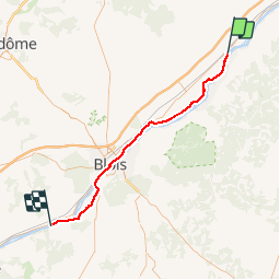
![](/images/other/stat-length.png)
![Randonnée Vélo Beaugency - De Beaugency à Chaumont sur Loire - Photo](https://media.geolcdn.com/t/1900/400/ext.pjpeg?maxdim=2&url=https%3A%2F%2Fservices.sitytrail.com%2FGeolivesWS%2FDownloadMedia.ashx%3FTrailID%3D215189%26Media%3D15792_4.jpg)
De Beaugency à Chaumont sur Loire
tracegps
Utilisateur
![Longueur](/images/other/stat-length.png)
![Altitude max](https://static1.geolcdn.com/siteimages/upload/files/1508320355ic_sort_altitude_max_24dp.png)
![Dénivelé positif](https://static1.geolcdn.com/siteimages/upload/files/1508320355ic_sort_den_pos_24dp.png)
![Km-Effort](/images/other/stat-length.png)
![Altitude min](https://static1.geolcdn.com/siteimages/upload/files/1508320355ic_sort_altitude_min_24dp.png)
![Dénivelé négatif](https://static1.geolcdn.com/siteimages/upload/files/1508320355ic_sort_den_neg_24dp.png)
![Boucle](https://static1.geolcdn.com/siteimages/upload/files/16400158638029165_repeat_loop_refresh_sync_direction_icon.png)
![Vélo](https://static1.geolcdn.com/sitytour/trail-icons/200.png)
4h00
Difficulté : Moyen
![Scannez ce code QR pour ouvrir la randonnée dans l'application SityTrail](https://capi.geolives.com/qq0zvz2zws4bq2lad0pu/sitytour/trails/215189/qr.png?size=200)
Application GPS de randonnée GRATUITE
À propos
Randonnée Vélo de 55 km à découvrir à Centre-Val de Loire, Loiret, Beaugency. Cette randonnée est proposée par tracegps.
Description
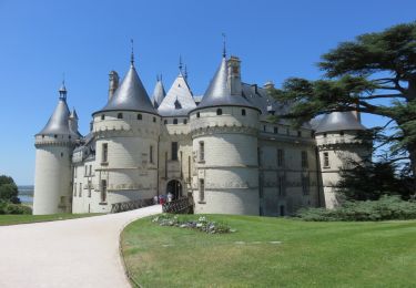
Une sortie à la journée à 15 km/h de moyenne à faire en famille, avec Pique-nique face au Château de Chaumont sur Loire. Pas de difficulté particulière et un périple magnifique. En profiter pour visiter le château et le Festival des Jardins à Chaummont. La gare d'Onzain à 1.5 kilomètre permet de revenir à Beaugency en 40 minutes pour une somme très modique.
Localisation
Commentaires
Randonnées à proximité
![Randonnée Marche Tavers - Travers 45 - Photo](https://media.geolcdn.com/t/375/260/b0df1624-eed1-42d6-aa64-04a3f1392bd1.jpg&format=jpg&maxdim=2)
![Marche Marche](https://static1.geolcdn.com/sitytour/trail-icons/101.png)
Marche
![](/images/other/stat-length.png)
![](https://static1.geolcdn.com/siteimages/upload/files/16400158638029165_repeat_loop_refresh_sync_direction_icon.png)
![Randonnée A pied Beaugency - Sentier de la petite Mauve - Photo](https://media.geolcdn.com/t/375/260/b33af960-a507-4803-b6a4-112f6d32b28f.jpeg&format=jpg&maxdim=2)
![A pied A pied](https://static1.geolcdn.com/sitytour/trail-icons/100.png)
A pied
![](/images/other/stat-length.png)
![](https://static1.geolcdn.com/siteimages/upload/files/16400158638029165_repeat_loop_refresh_sync_direction_icon.png)
![Randonnée Marche Tavers - Balade Tavers-Beaugency - Photo](https://media.geolcdn.com/t/375/260/03ddee36-28f4-4847-ba6b-37d1765e9fe7.jpg&format=jpg&maxdim=2)
![Marche Marche](https://static1.geolcdn.com/sitytour/trail-icons/101.png)
Marche
![](/images/other/stat-length.png)
![](https://static1.geolcdn.com/siteimages/upload/files/16400158638029165_repeat_loop_refresh_sync_direction_icon.png)
![Randonnée Vélo Beaugency - Loire à vélo de Beaugency à Rochecorbon - Photo](https://media.geolcdn.com/t/375/260/ext.jpg?maxdim=2&url=https%3A%2F%2Fservices.sitytrail.com%2FGeolivesWS%2FDownloadMedia.ashx%3FTrailID%3D450835%26Media%3De384ee0a-a013-4f5c-8acb-c7de5681f34a.JPG)
![Vélo Vélo](https://static1.geolcdn.com/sitytour/trail-icons/200.png)
Vélo
![](/images/other/stat-length.png)
![](https://static1.geolcdn.com/siteimages/upload/files/16400158638029165_repeat_loop_refresh_sync_direction_icon.png)
![Randonnée Cyclotourisme Beaugency - Beaugency à Candé sur Beuvron - Photo](https://media.geolcdn.com/t/375/260/d5feb751-2511-4f01-a4a1-048b0f873842.jpg&format=jpg&maxdim=2)
![Cyclotourisme Cyclotourisme](https://static1.geolcdn.com/sitytour/trail-icons/204.png)
Cyclotourisme
![](/images/other/stat-length.png)
![](https://static1.geolcdn.com/siteimages/upload/files/16400158638029165_repeat_loop_refresh_sync_direction_icon.png)
![Randonnée Marche Beaugency - boucle1versTavers - Photo](https://media.geolcdn.com/t/375/260/c0601744-a38f-4df5-ad30-a58222f01778.jpg&format=jpg&maxdim=2)
![Marche Marche](https://static1.geolcdn.com/sitytour/trail-icons/101.png)
Marche
![](/images/other/stat-length.png)
![](https://static1.geolcdn.com/siteimages/upload/files/16400158638029165_repeat_loop_refresh_sync_direction_icon.png)
![Randonnée Marche Tavers - rando tavers - Photo](https://media.geolcdn.com/t/375/260/15eec2ff-20a6-4c2d-9cb3-88312c888da1.jpg&format=jpg&maxdim=2)
![Marche Marche](https://static1.geolcdn.com/sitytour/trail-icons/101.png)
Marche
![](/images/other/stat-length.png)
![](https://static1.geolcdn.com/siteimages/upload/files/16400158638029165_repeat_loop_refresh_sync_direction_icon.png)
![Randonnée Marche Tavers - Tavers - Lestiou - Photo](https://media.geolcdn.com/t/375/260/223333a8-f501-41b1-8d06-7d85d76d1876.jpg&format=jpg&maxdim=2)
![Marche Marche](https://static1.geolcdn.com/sitytour/trail-icons/101.png)
Marche
![](/images/other/stat-length.png)
![](https://static1.geolcdn.com/siteimages/upload/files/16400158638029165_repeat_loop_refresh_sync_direction_icon.png)
![Randonnée Marche Beaugency - L'âne et le chat - Balade Beaugency - Photo](https://media.geolcdn.com/t/375/260/77dc723c-f140-4e63-92ad-ce6b3071483e.jpg&format=jpg&maxdim=2)
![Marche Marche](https://static1.geolcdn.com/sitytour/trail-icons/101.png)
Marche
![](/images/other/stat-length.png)
![](https://static1.geolcdn.com/siteimages/upload/files/16400158638029165_repeat_loop_refresh_sync_direction_icon.png)