![](/images/other/stat-length.png)
![Randonnée Marche Voyennes - La Courtemanche - Voyennes - Photo](https://media.geolcdn.com/t/1900/400/ext.pjpeg?maxdim=2&url=https%3A%2F%2Fservices.sitytrail.com%2FGeolivesWS%2FDownloadMedia.ashx%3FTrailID%3D215156%26Media%3D15751_2.jpg)
La Courtemanche - Voyennes
tracegps
Utilisateur
![Longueur](/images/other/stat-length.png)
Longueur
10,1 km
![Altitude max](https://static1.geolcdn.com/siteimages/upload/files/1508320355ic_sort_altitude_max_24dp.png)
Altitude max
77 m
![Dénivelé positif](https://static1.geolcdn.com/siteimages/upload/files/1508320355ic_sort_den_pos_24dp.png)
Dénivelé positif
67 m
![Km-Effort](/images/other/stat-length.png)
Km-Effort
11 km
![Altitude min](https://static1.geolcdn.com/siteimages/upload/files/1508320355ic_sort_altitude_min_24dp.png)
Altitude min
54 m
![Dénivelé négatif](https://static1.geolcdn.com/siteimages/upload/files/1508320355ic_sort_den_neg_24dp.png)
Dénivelé négatif
66 m
![Boucle](https://static1.geolcdn.com/siteimages/upload/files/16400158638029165_repeat_loop_refresh_sync_direction_icon.png)
Boucle
Oui
Date de création :
2014-12-10 00:00:00.0
Dernière modification :
2014-12-10 00:00:00.0
![Marche](https://static1.geolcdn.com/sitytour/trail-icons/101.png)
2h40
Difficulté : Moyen
![Scannez ce code QR pour ouvrir la randonnée dans l'application SityTrail](https://capi.geolives.com/qq0zvz2zws4bq2lad0pu/sitytour/trails/215156/qr.png?size=200)
Application GPS de randonnée GRATUITE
À propos
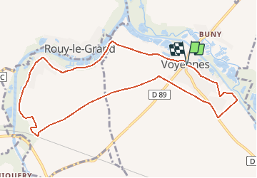
Randonnée Marche de 10,1 km à découvrir à Hauts-de-France, Somme, Voyennes. Cette randonnée est proposée par tracegps.
Description
Départ de la place de Voyennes pour une balade entre Somme, canal du Nord, marais et plaines pour découvrir des paysages authentiques où l'Histoire n'est jamais bien loin. Téléchargez la fiche du circuit.
Localisation
Pays :
France
Région :
Hauts-de-France
Département/Province :
Somme
Commune :
Voyennes
Localité :
Unknown
Départ:(Dec)
Départ:(UTM)
498855 ; 5513331 (31U) N.
Commentaires
Randonnées à proximité
![Randonnée Marche Pargny - Circuit du clos Bouteille -Pargny - Photo](https://media.geolcdn.com/t/375/260/ext.jpg?maxdim=2&url=https%3A%2F%2Fservices.sitytrail.com%2FGeolivesWS%2FDownloadMedia.ashx%3FTrailID%3D1055081%26Media%3Dfix__20181011170913.jpg)
![Marche Marche](https://static1.geolcdn.com/sitytour/trail-icons/101.png)
Circuit du clos Bouteille -Pargny
Marche
Facile
Pargny,
Hauts-de-France,
Somme,
France
![](/images/other/stat-length.png)
11,5 km | 12,4 km-effort
2h 50min
![](https://static1.geolcdn.com/siteimages/upload/files/16400158638029165_repeat_loop_refresh_sync_direction_icon.png)
Oui
![Randonnée Marche Sancourt - Source Magloire - Photo](https://media.geolcdn.com/t/375/260/6691ca2c-8822-424b-a40f-47067502ee53.jpg&format=jpg&maxdim=2)
![Marche Marche](https://static1.geolcdn.com/sitytour/trail-icons/101.png)
Source Magloire
Marche
Moyen
Sancourt,
Hauts-de-France,
Somme,
France
![](/images/other/stat-length.png)
14,2 km | 15,4 km-effort
3h 11min
![](https://static1.geolcdn.com/siteimages/upload/files/16400158638029165_repeat_loop_refresh_sync_direction_icon.png)
Non
![Randonnée Marche Pargny - Circuit du Clos Bouteille - Pargny - Photo](https://media.geolcdn.com/t/375/260/ext.jpg?maxdim=2&url=https%3A%2F%2Fservices.sitytrail.com%2FGeolivesWS%2FDownloadMedia.ashx%3FTrailID%3D110549%26Media%3D6106_2.jpg)
![Marche Marche](https://static1.geolcdn.com/sitytour/trail-icons/101.png)
Circuit du Clos Bouteille - Pargny
Marche
Moyen
Pargny,
Hauts-de-France,
Somme,
France
![](/images/other/stat-length.png)
10,7 km | 11,5 km-effort
2h 0min
![](https://static1.geolcdn.com/siteimages/upload/files/16400158638029165_repeat_loop_refresh_sync_direction_icon.png)
Oui
![Randonnée Marche Pargny - Circuit du Fief Doré - Pargny - Photo](https://media.geolcdn.com/t/375/260/ext.jpg?maxdim=2&url=https%3A%2F%2Fservices.sitytrail.com%2FGeolivesWS%2FDownloadMedia.ashx%3FTrailID%3D110518%26Media%3D6062_2.jpg)
![Marche Marche](https://static1.geolcdn.com/sitytour/trail-icons/101.png)
Circuit du Fief Doré - Pargny
Marche
Moyen
Pargny,
Hauts-de-France,
Somme,
France
![](/images/other/stat-length.png)
10,7 km | 11,5 km-effort
2h 40min
![](https://static1.geolcdn.com/siteimages/upload/files/16400158638029165_repeat_loop_refresh_sync_direction_icon.png)
Oui
![Randonnée Marche Voyennes - Circuit de la Courtemanche - Voyennes - Photo](https://media.geolcdn.com/t/375/260/ext.jpg?maxdim=2&url=https%3A%2F%2Fservices.sitytrail.com%2FGeolivesWS%2FDownloadMedia.ashx%3FTrailID%3D110492%26Media%3D6021_2.jpg)
![Marche Marche](https://static1.geolcdn.com/sitytour/trail-icons/101.png)
Circuit de la Courtemanche - Voyennes
Marche
Moyen
Voyennes,
Hauts-de-France,
Somme,
France
![](/images/other/stat-length.png)
11,9 km | 12,9 km-effort
3h 0min
![](https://static1.geolcdn.com/siteimages/upload/files/16400158638029165_repeat_loop_refresh_sync_direction_icon.png)
Oui
![Randonnée Marche Nesle - Circuit de la fontaine Saint Quentin - Nesle - Photo](https://media.geolcdn.com/t/375/260/ext.jpg?maxdim=2&url=https%3A%2F%2Fservices.sitytrail.com%2FGeolivesWS%2FDownloadMedia.ashx%3FTrailID%3D110479%26Media%3D5995_1.jpg)
![Marche Marche](https://static1.geolcdn.com/sitytour/trail-icons/101.png)
Circuit de la fontaine Saint Quentin - Nesle
Marche
Moyen
Nesle,
Hauts-de-France,
Somme,
France
![](/images/other/stat-length.png)
12,5 km | 13,8 km-effort
3h 10min
![](https://static1.geolcdn.com/siteimages/upload/files/16400158638029165_repeat_loop_refresh_sync_direction_icon.png)
Oui
![Randonnée Marche Hombleux - Circuit de la Croix Saint Claude - Hombleux - Photo](https://media.geolcdn.com/t/375/260/ext.jpg?maxdim=2&url=https%3A%2F%2Fservices.sitytrail.com%2FGeolivesWS%2FDownloadMedia.ashx%3FTrailID%3D110361%26Media%3D5822_1.jpg)
![Marche Marche](https://static1.geolcdn.com/sitytour/trail-icons/101.png)
Circuit de la Croix Saint Claude - Hombleux
Marche
Difficile
Hombleux,
Hauts-de-France,
Somme,
France
![](/images/other/stat-length.png)
15,7 km | 16,7 km-effort
4h 0min
![](https://static1.geolcdn.com/siteimages/upload/files/16400158638029165_repeat_loop_refresh_sync_direction_icon.png)
Oui
![Randonnée Marche Sancourt - Source Magloire - Photo](https://media.geolcdn.com/t/375/260/ext.jpg?maxdim=2&url=https%3A%2F%2Fstatic1.geolcdn.com%2Fsiteimages%2Fupload%2Ffiles%2F1553511878bg_sport_marche.png)
![Marche Marche](https://static1.geolcdn.com/sitytour/trail-icons/101.png)
Source Magloire
Marche
Difficile
Sancourt,
Hauts-de-France,
Somme,
France
![](/images/other/stat-length.png)
12,8 km | 13,8 km-effort
3h 8min
![](https://static1.geolcdn.com/siteimages/upload/files/16400158638029165_repeat_loop_refresh_sync_direction_icon.png)
Oui
![Randonnée Marche Pargny - le clos bouteille - Photo](https://media.geolcdn.com/t/375/260/ext.jpg?maxdim=2&url=https%3A%2F%2Fstatic1.geolcdn.com%2Fsiteimages%2Fupload%2Ffiles%2F1553511878bg_sport_marche.png)
![Marche Marche](https://static1.geolcdn.com/sitytour/trail-icons/101.png)
le clos bouteille
Marche
Moyen
Pargny,
Hauts-de-France,
Somme,
France
![](/images/other/stat-length.png)
9,5 km | 10,3 km-effort
2h 49min
![](https://static1.geolcdn.com/siteimages/upload/files/16400158638029165_repeat_loop_refresh_sync_direction_icon.png)
Oui
belle balade un peu difficile dur les chemins agricoles. un tres important dépôt de gravât modifie le chemin. veuillez apporter la correction merci