![](/images/other/stat-length.png)
![Randonnée V.T.T. Châteaudun - Le moulin de Courgain - Chateaudin - Photo](https://media.geolcdn.com/t/1900/400/ext.pjpeg?maxdim=2&url=https%3A%2F%2Fstatic1.geolcdn.com%2Fsiteimages%2Fupload%2Ffiles%2F1524743154velo.jpg)
Le moulin de Courgain - Chateaudin
tracegps
Utilisateur
![Longueur](/images/other/stat-length.png)
Longueur
34 km
![Altitude max](https://static1.geolcdn.com/siteimages/upload/files/1508320355ic_sort_altitude_max_24dp.png)
Altitude max
154 m
![Dénivelé positif](https://static1.geolcdn.com/siteimages/upload/files/1508320355ic_sort_den_pos_24dp.png)
Dénivelé positif
412 m
![Km-Effort](/images/other/stat-length.png)
Km-Effort
39 km
![Altitude min](https://static1.geolcdn.com/siteimages/upload/files/1508320355ic_sort_altitude_min_24dp.png)
Altitude min
97 m
![Dénivelé négatif](https://static1.geolcdn.com/siteimages/upload/files/1508320355ic_sort_den_neg_24dp.png)
Dénivelé négatif
401 m
![Boucle](https://static1.geolcdn.com/siteimages/upload/files/16400158638029165_repeat_loop_refresh_sync_direction_icon.png)
Boucle
Oui
Date de création :
2014-12-10 00:00:00.0
Dernière modification :
2014-12-10 00:00:00.0
![V.T.T.](https://static1.geolcdn.com/sitytour/trail-icons/202.png)
1h49
Difficulté : Difficile
![Scannez ce code QR pour ouvrir la randonnée dans l'application SityTrail](https://capi.geolives.com/qq0zvz2zws4bq2lad0pu/sitytour/trails/215149/qr.png?size=200)
Application GPS de randonnée GRATUITE
À propos
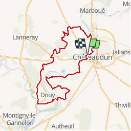
Randonnée V.T.T. de 34 km à découvrir à Centre-Val de Loire, Eure-et-Loir, Châteaudun. Cette randonnée est proposée par tracegps.
Description
Circuit VTT intéressant, vallonné, comportant plusieurs types de terrains. Par contre, de gros problèmes de balisages, mieux vaut avoir le circuit sur GPS que le dépliant de l'office de tourisme de l'Eure et Loir qui comporte des erreurs.
Localisation
Pays :
France
Région :
Centre-Val de Loire
Département/Province :
Eure-et-Loir
Commune :
Châteaudun
Localité :
Unknown
Départ:(Dec)
Départ:(UTM)
375160 ; 5325614 (31U) N.
Commentaires
Randonnées à proximité
![Randonnée Marche Châteaudun - Châteaudun - Marboué - Photo](https://media.geolcdn.com/t/375/260/6fc7324d-3026-46fa-8ba5-43d23d854789.jpg&format=jpg&maxdim=2)
![Marche Marche](https://static1.geolcdn.com/sitytour/trail-icons/101.png)
Châteaudun - Marboué
Marche
Moyen
Châteaudun,
Centre-Val de Loire,
Eure-et-Loir,
France
![](/images/other/stat-length.png)
19,2 km | 22 km-effort
6h 25min
![](https://static1.geolcdn.com/siteimages/upload/files/16400158638029165_repeat_loop_refresh_sync_direction_icon.png)
Oui
![Randonnée V.T.T. Châteaudun - Le moulin de Courgain - Châteaudin - Photo](https://media.geolcdn.com/t/375/260/ext.jpg?maxdim=2&url=https%3A%2F%2Fservices.sitytrail.com%2FGeolivesWS%2FDownloadMedia.ashx%3FTrailID%3D215150%26Media%3D15745_2.jpg)
![V.T.T. V.T.T.](https://static1.geolcdn.com/sitytour/trail-icons/202.png)
Le moulin de Courgain - Châteaudin
V.T.T.
Difficile
Châteaudun,
Centre-Val de Loire,
Eure-et-Loir,
France
![](/images/other/stat-length.png)
33 km | 39 km-effort
1h 49min
![](https://static1.geolcdn.com/siteimages/upload/files/16400158638029165_repeat_loop_refresh_sync_direction_icon.png)
Oui
![Randonnée Marche Châteaudun - Châteaudun 1 - Photo](https://media.geolcdn.com/t/375/260/ext.jpg?maxdim=2&url=https%3A%2F%2Fstatic1.geolcdn.com%2Fsiteimages%2Fupload%2Ffiles%2F1553511878bg_sport_marche.png)
![Marche Marche](https://static1.geolcdn.com/sitytour/trail-icons/101.png)
Châteaudun 1
Marche
Moyen
Châteaudun,
Centre-Val de Loire,
Eure-et-Loir,
France
![](/images/other/stat-length.png)
9 km | 10,2 km-effort
2h 46min
![](https://static1.geolcdn.com/siteimages/upload/files/16400158638029165_repeat_loop_refresh_sync_direction_icon.png)
Oui
![Randonnée A pied Cloyes-les-Trois-Rivières - Douy PC27sept2020 - Photo](https://media.geolcdn.com/t/375/260/ext.jpg?maxdim=2&url=https%3A%2F%2Fstatic1.geolcdn.com%2Fsiteimages%2Fupload%2Ffiles%2F1545311037marcheuse_200dpi.jpg)
![A pied A pied](https://static1.geolcdn.com/sitytour/trail-icons/100.png)
Douy PC27sept2020
A pied
Moyen
Cloyes-les-Trois-Rivières,
Centre-Val de Loire,
Eure-et-Loir,
France
![](/images/other/stat-length.png)
11,3 km | 13 km-effort
Inconnu
![](https://static1.geolcdn.com/siteimages/upload/files/16400158638029165_repeat_loop_refresh_sync_direction_icon.png)
Oui
![Randonnée A pied Châteaudun - Châteaudun PC25sept2020 - Photo](https://media.geolcdn.com/t/375/260/ext.jpg?maxdim=2&url=https%3A%2F%2Fstatic1.geolcdn.com%2Fsiteimages%2Fupload%2Ffiles%2F1545311037marcheuse_200dpi.jpg)
![A pied A pied](https://static1.geolcdn.com/sitytour/trail-icons/100.png)
Châteaudun PC25sept2020
A pied
Moyen
Châteaudun,
Centre-Val de Loire,
Eure-et-Loir,
France
![](/images/other/stat-length.png)
9,6 km | 11,1 km-effort
Inconnu
![](https://static1.geolcdn.com/siteimages/upload/files/16400158638029165_repeat_loop_refresh_sync_direction_icon.png)
Oui
![Randonnée Marche nordique Châteaudun - Marche_Chateaudun_20140326 - Photo](https://media.geolcdn.com/t/375/260/ext.jpg?maxdim=2&url=https%3A%2F%2Fstatic1.geolcdn.com%2Fsiteimages%2Fupload%2Ffiles%2F1545311037marcheuse_200dpi.jpg)
![Marche nordique Marche nordique](https://static1.geolcdn.com/sitytour/trail-icons/102.png)
Marche_Chateaudun_20140326
Marche nordique
Difficile
Châteaudun,
Centre-Val de Loire,
Eure-et-Loir,
France
![](/images/other/stat-length.png)
21 km | 24 km-effort
3h 42min
![](https://static1.geolcdn.com/siteimages/upload/files/16400158638029165_repeat_loop_refresh_sync_direction_icon.png)
Oui
![Randonnée Marche Châteaudun - Chateaudun (Boucle Plaines et Vallées du Dunois) - Photo](https://media.geolcdn.com/t/375/260/ext.jpg?maxdim=2&url=https%3A%2F%2Fstatic1.geolcdn.com%2Fsiteimages%2Fupload%2Ffiles%2F1553511878bg_sport_marche.png)
![Marche Marche](https://static1.geolcdn.com/sitytour/trail-icons/101.png)
Chateaudun (Boucle Plaines et Vallées du Dunois)
Marche
Facile
Châteaudun,
Centre-Val de Loire,
Eure-et-Loir,
France
![](/images/other/stat-length.png)
18,9 km | 22 km-effort
4h 47min
![](https://static1.geolcdn.com/siteimages/upload/files/16400158638029165_repeat_loop_refresh_sync_direction_icon.png)
Oui
![Randonnée Marche Châteaudun - 009 Chateaudun Cloyes - Photo](https://media.geolcdn.com/t/375/260/ext.jpg?maxdim=2&url=https%3A%2F%2Fstatic1.geolcdn.com%2Fsiteimages%2Fupload%2Ffiles%2F1553511878bg_sport_marche.png)
![Marche Marche](https://static1.geolcdn.com/sitytour/trail-icons/101.png)
009 Chateaudun Cloyes
Marche
Très facile
Châteaudun,
Centre-Val de Loire,
Eure-et-Loir,
France
![](/images/other/stat-length.png)
13,6 km | 15 km-effort
3h 19min
![](https://static1.geolcdn.com/siteimages/upload/files/16400158638029165_repeat_loop_refresh_sync_direction_icon.png)
Non
![Randonnée Canoë - kayak Châteaudun - Kayak chateaudun - Photo](https://media.geolcdn.com/t/375/260/ext.jpg?maxdim=2&url=https%3A%2F%2Fsecurestorage.geolives.com%2Fsitytour%2Ftrail-bg%2Fdefault.jpg)
![Canoë - kayak Canoë - kayak](https://static1.geolcdn.com/sitytour/trail-icons/703.png)
Kayak chateaudun
Canoë - kayak
Châteaudun,
Centre-Val de Loire,
Eure-et-Loir,
France
![](/images/other/stat-length.png)
6,6 km | 7,3 km-effort
1h 59min
![](https://static1.geolcdn.com/siteimages/upload/files/16400158638029165_repeat_loop_refresh_sync_direction_icon.png)
Oui