Randonnée Marche Saint-Jean-Saint-Nicolas - Le Palestre - Photo
 gillesfleutot
gillesfleutot

Utilisateur

© OpenStreetMap contributors
Longueur
Longueur
17,3 km
Altitude max
Altitude max
2188 m
Dénivelé positif
Dénivelé positif
958 m
Km-Effort
Km-Effort  
31 km
Altitude min
Altitude min
1108 m
Dénivelé négatif
Dénivelé négatif
1318 m
Boucle
Boucle
Non
Date de création :
2019-07-25 08:17:27.087
Dernière modification :
2019-07-25 16:47:10.338

(1 Avis)

Marche
Marche
4h59
Difficulté : Difficile

Scannez ce code QR pour ouvrir la randonnée dans l'application SityTrail

Application GPS de randonnée GRATUITE

Logo SityTrail SityTrail

IGN / Instituts géographiques

Télécharger SityTrail sur l'App Store Télécharger SityTrail sur Google Play

Logo SityTrail SityTrail World

Le monde est à vous

Télécharger SityTrail sur l'App Store Télécharger SityTrail sur Google Play Télécharger SityTrail sur Huawei AppGallery

À propos

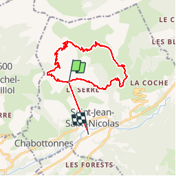
Randonnée Marche de 17,3 km à découvrir à Provence-Alpes-Côte d'Azur, Hautes-Alpes, Saint-Jean-Saint-Nicolas. Cette randonnée est proposée par gillesfleutot.

Profil altimétrique

Localisation

Pays :
France
Région :
Provence-Alpes-Côte d'Azur
Département/Province :
Hautes-Alpes
Commune :
Saint-Jean-Saint-Nicolas
Localité :
Unknown
Départ:(UTM)
278525 ; 4951469 (32T) N.

Commentaires

Veuillez vous connecter pour laisser un commentaire ou une note


très belle randonnée mais je la déconseille aux personnes sujettes au vertige. Le départ se fait habituellement du Richard. Peu de places disponibles au départ.


Randonnées à proximité

Randonnée Marche Saint-Jean-Saint-Nicolas - Circuit de Costebelle - Photo
Marche
Dervalmarc

Marche

Très facile
(2)
Saint-Jean-Saint-Nicolas, Provence-Alpes-Côte d'Azur, Hautes-Alpes, France
7,4 km | 12,1 km-effort
2h 16min
Oui
Randonnée Marche Saint-Jean-Saint-Nicolas - Le Palastre - Photo
Marche
GUIDE
Marco05

Marche

Moyen
Saint-Jean-Saint-Nicolas, Provence-Alpes-Côte d'Azur, Hautes-Alpes, France
9,1 km | 17,9 km-effort
4h 4min
Oui
Randonnée Marche Saint-Michel-de-Chaillol - Col de l'Escalier - Photo
Marche
GUIDE
Marco05

Marche

Difficile
Saint-Michel-de-Chaillol, Provence-Alpes-Côte d'Azur, Hautes-Alpes, France
16 km | 27 km-effort
6h 13min
Oui
Randonnée A pied Champoléon - Refuge du Tourond - Photo
A pied
GUIDE
Marco05

A pied

Facile
Champoléon, Provence-Alpes-Côte d'Azur, Hautes-Alpes, France
8,4 km | 14,2 km-effort
3h 14min
Oui
Randonnée Marche Saint-Michel-de-Chaillol - Pic Queyrel - Photo
Marche
GUIDE
Marco05

Marche

Difficile
Saint-Michel-de-Chaillol, Provence-Alpes-Côte d'Azur, Hautes-Alpes, France
10,4 km | 19,8 km-effort
4h 29min
Oui
Randonnée Marche Saint-Michel-de-Chaillol - Pic du Tourond - Photo
Marche
GUIDE
Marco05

Marche

Très difficile
Saint-Michel-de-Chaillol, Provence-Alpes-Côte d'Azur, Hautes-Alpes, France
13,7 km | 27 km-effort
6h 14min
Oui
Randonnée Marche Champoléon - Méollion - Photo
Marche
GUIDE
Marco05

Marche

Moyen
Champoléon, Provence-Alpes-Côte d'Azur, Hautes-Alpes, France
7,5 km | 13,7 km-effort
2h 59min
Oui
Randonnée Marche Saint-Michel-de-Chaillol - Lac de Malcros - Photo
Marche
GUIDE
Marco05

Marche

Très difficile
Saint-Michel-de-Chaillol, Provence-Alpes-Côte d'Azur, Hautes-Alpes, France
18,7 km | 34 km-effort
7h 43min
Oui
Randonnée Marche Champoléon - Balade Vallée Champoléon - Photo
Marche
GUIDE
nadinebondoux

Marche

Facile
Champoléon, Provence-Alpes-Côte d'Azur, Hautes-Alpes, France
9,5 km | 12,2 km-effort
2h 40min
Oui


Fermer
Mes abonnements