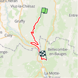
![](/images/other/stat-length.png)
![Randonnée Marche Leschaux - Randonnée de Crêt de Chatillon à Saint-Martin par Pont du Diable - Photo](https://media.geolcdn.com/t/1900/400/ext.pjpeg?maxdim=2&url=https%3A%2F%2Fservices.sitytrail.com%2FGeolivesWS%2FDownloadMedia.ashx%3FTrailID%3D214998%26Media%3D15570_6.jpg)
Randonnée de Crêt de Chatillon à Saint-Martin par Pont du Diable
tracegps
Utilisateur
![Longueur](/images/other/stat-length.png)
![Altitude max](https://static1.geolcdn.com/siteimages/upload/files/1508320355ic_sort_altitude_max_24dp.png)
![Dénivelé positif](https://static1.geolcdn.com/siteimages/upload/files/1508320355ic_sort_den_pos_24dp.png)
![Km-Effort](/images/other/stat-length.png)
![Altitude min](https://static1.geolcdn.com/siteimages/upload/files/1508320355ic_sort_altitude_min_24dp.png)
![Dénivelé négatif](https://static1.geolcdn.com/siteimages/upload/files/1508320355ic_sort_den_neg_24dp.png)
![Boucle](https://static1.geolcdn.com/siteimages/upload/files/16400158638029165_repeat_loop_refresh_sync_direction_icon.png)
![Marche](https://static1.geolcdn.com/sitytour/trail-icons/101.png)
4h00
Difficulté : Moyen
![Scannez ce code QR pour ouvrir la randonnée dans l'application SityTrail](https://capi.geolives.com/qq0zvz2zws4bq2lad0pu/sitytour/trails/214998/qr.png?size=200)
Application GPS de randonnée GRATUITE
À propos
Randonnée Marche de 14,8 km à découvrir à Auvergne-Rhône-Alpes, Haute-Savoie, Leschaux. Cette randonnée est proposée par tracegps.
Description
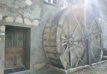
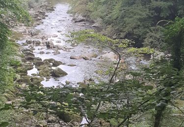
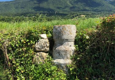
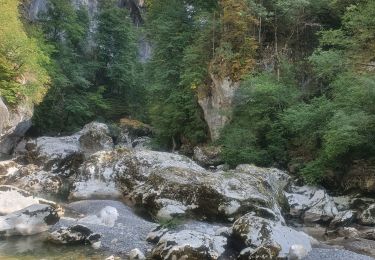
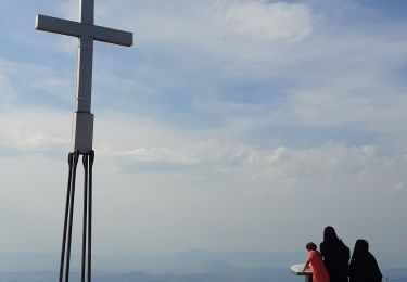
Départ sur Crêt de Chatillon, au carrefour de Semnoz-Alpes (vue sur les Alpes et le Mont-Blanc), chalets de Leschaux, refuge de Semnoz, granges de la Figlia (vue sur les Tours-Saint-Jacques), village d’Allèves, traversée de la D912, Pont du Diable. Après une courte montée dans un chemin forestier, on entre dans le village de Saint-Martin.
Localisation
Commentaires
Randonnées à proximité
![Randonnée Marche Cusy - 13-09-2022 La Grand-Raie au Col de la Cochette - Photo](https://media.geolcdn.com/t/375/260/6cba586f-c088-48b0-8a7d-67e2ef29bd8a.jpg&format=jpg&maxdim=2)
![Marche Marche](https://static1.geolcdn.com/sitytour/trail-icons/101.png)
Marche
![](/images/other/stat-length.png)
![](https://static1.geolcdn.com/siteimages/upload/files/16400158638029165_repeat_loop_refresh_sync_direction_icon.png)
![Randonnée Marche Allèves - 06-09-2022 Tours Saint Jacques-Grottes de Bange - Photo](https://media.geolcdn.com/t/375/260/7a87734e-615b-4914-a2f6-8cd0e03da331.jpg&format=jpg&maxdim=2)
![Marche Marche](https://static1.geolcdn.com/sitytour/trail-icons/101.png)
Marche
![](/images/other/stat-length.png)
![](https://static1.geolcdn.com/siteimages/upload/files/16400158638029165_repeat_loop_refresh_sync_direction_icon.png)
![Randonnée Marche Saint-Jorioz - Saint Jorioz - Boucle du Laudon - Photo](https://media.geolcdn.com/t/375/260/9c7ab231-8d9b-40ca-b746-90a001c95581.jpg&format=jpg&maxdim=2)
![Marche Marche](https://static1.geolcdn.com/sitytour/trail-icons/101.png)
Marche
![](/images/other/stat-length.png)
![](https://static1.geolcdn.com/siteimages/upload/files/16400158638029165_repeat_loop_refresh_sync_direction_icon.png)
![Randonnée Marche Cusy - Les chaos de Cheran - Photo](https://media.geolcdn.com/t/375/260/7e19bf6d-564b-481b-864d-0e6de1762649.jpg&format=jpg&maxdim=2)
![Marche Marche](https://static1.geolcdn.com/sitytour/trail-icons/101.png)
Marche
![](/images/other/stat-length.png)
![](https://static1.geolcdn.com/siteimages/upload/files/16400158638029165_repeat_loop_refresh_sync_direction_icon.png)
![Randonnée Marche Viuz-la-Chiésaz - Circuit de Viuz La Chiesaz - Photo](https://media.geolcdn.com/t/375/260/5ec881e2-7522-436f-aeef-d18c681a45ff.jpg&format=jpg&maxdim=2)
![Marche Marche](https://static1.geolcdn.com/sitytour/trail-icons/101.png)
Marche
![](/images/other/stat-length.png)
![](https://static1.geolcdn.com/siteimages/upload/files/16400158638029165_repeat_loop_refresh_sync_direction_icon.png)
![Randonnée Marche Cusy - Chaos. du Cheran - Photo](https://media.geolcdn.com/t/375/260/ext.jpg?maxdim=2&url=https%3A%2F%2Fstatic1.geolcdn.com%2Fsiteimages%2Fupload%2Ffiles%2F1553511878bg_sport_marche.png)
![Marche Marche](https://static1.geolcdn.com/sitytour/trail-icons/101.png)
Marche
![](/images/other/stat-length.png)
![](https://static1.geolcdn.com/siteimages/upload/files/16400158638029165_repeat_loop_refresh_sync_direction_icon.png)
![Randonnée Marche Cusy - 14-08-2022 Pont de Cusy - Pont de l'abîme - Photo](https://media.geolcdn.com/t/375/260/afefb47b-f53a-4dff-bf88-24c102fec5de.jpg&format=jpg&maxdim=2)
![Marche Marche](https://static1.geolcdn.com/sitytour/trail-icons/101.png)
Marche
![](/images/other/stat-length.png)
![](https://static1.geolcdn.com/siteimages/upload/files/16400158638029165_repeat_loop_refresh_sync_direction_icon.png)
![Randonnée Marche Viuz-la-Chiésaz - Semnoz, mon tour des lacs et des crêts - Photo](https://media.geolcdn.com/t/375/260/783af83e-3511-42c6-b5b4-a812fdab5578.jpg&format=jpg&maxdim=2)
![Marche Marche](https://static1.geolcdn.com/sitytour/trail-icons/101.png)
Marche
![](/images/other/stat-length.png)
![](https://static1.geolcdn.com/siteimages/upload/files/16400158638029165_repeat_loop_refresh_sync_direction_icon.png)
![Randonnée A pied Allèves - Montée Romaine - Photo](https://media.geolcdn.com/t/375/260/2cb3b15d-19a4-48cb-8909-b58d63db275a.jpeg&format=jpg&maxdim=2)
![A pied A pied](https://static1.geolcdn.com/sitytour/trail-icons/100.png)
A pied
![](/images/other/stat-length.png)
![](https://static1.geolcdn.com/siteimages/upload/files/16400158638029165_repeat_loop_refresh_sync_direction_icon.png)