![](/images/other/stat-length.png)
![Randonnée Marche Wingen-sur-Moder - De Wingen sur Moder à Ingwiller - Photo](https://media.geolcdn.com/t/1900/400/ext.pjpeg?maxdim=2&url=https%3A%2F%2Fservices.sitytrail.com%2FGeolivesWS%2FDownloadMedia.ashx%3FTrailID%3D214892%26Media%3D15443_3.jpg)
De Wingen sur Moder à Ingwiller
tracegps
Utilisateur
![Longueur](/images/other/stat-length.png)
![Altitude max](https://static1.geolcdn.com/siteimages/upload/files/1508320355ic_sort_altitude_max_24dp.png)
![Dénivelé positif](https://static1.geolcdn.com/siteimages/upload/files/1508320355ic_sort_den_pos_24dp.png)
![Km-Effort](/images/other/stat-length.png)
![Altitude min](https://static1.geolcdn.com/siteimages/upload/files/1508320355ic_sort_altitude_min_24dp.png)
![Dénivelé négatif](https://static1.geolcdn.com/siteimages/upload/files/1508320355ic_sort_den_neg_24dp.png)
![Boucle](https://static1.geolcdn.com/siteimages/upload/files/16400158638029165_repeat_loop_refresh_sync_direction_icon.png)
![Marche](https://static1.geolcdn.com/sitytour/trail-icons/101.png)
6h30
Difficulté : Difficile
![Scannez ce code QR pour ouvrir la randonnée dans l'application SityTrail](https://capi.geolives.com/qq0zvz2zws4bq2lad0pu/sitytour/trails/214892/qr.png?size=200)
Application GPS de randonnée GRATUITE
À propos
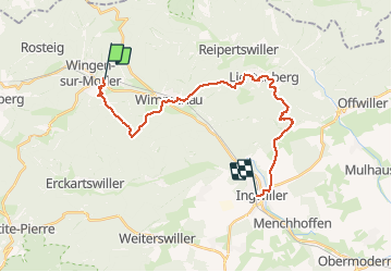
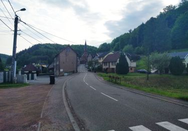
Randonnée Marche de 22 km à découvrir à Grand Est, Bas-Rhin, Wingen-sur-Moder. Cette randonnée est proposée par tracegps.
Description
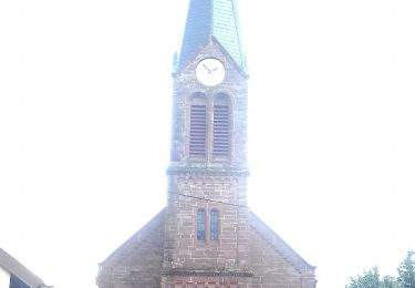
Parcours qui chemine entre Wingen sur Moder et Ingwiller (67), au cœur d’une forêt mixte de l’Alsace du nord. Il faut si l’on veut prendre toute la mesure de ce circuit aller visiter le Musée Lalique à Wingen sur Moder, se plonger dans l’univers moyenâgeux du château de Lichtenberg ou/et s’attarder devant les panneaux pédagogiques du sentier botanique d’Ingwiller. Les points de départ et d'arrivée de cette randonnée sont desservis par le train.
Localisation
Commentaires
Randonnées à proximité
![Randonnée A pied Puberg - Disque vert - Photo](https://media.geolcdn.com/t/375/260/038b5fbd-ad7d-4d8f-a6b9-4f60e8eebeb8.jpeg&format=jpg&maxdim=2)
![A pied A pied](https://static1.geolcdn.com/sitytour/trail-icons/100.png)
![Randonnée A pied Zittersheim - Anneau jaune - Photo](https://media.geolcdn.com/t/375/260/40af32f9-2f69-4f07-9a93-cacfd66f615c.jpeg&format=jpg&maxdim=2)
![A pied A pied](https://static1.geolcdn.com/sitytour/trail-icons/100.png)
A pied
![](/images/other/stat-length.png)
![](https://static1.geolcdn.com/siteimages/upload/files/16400158638029165_repeat_loop_refresh_sync_direction_icon.png)
![Randonnée A pied Wimmenau - Rectangle jaune barré de blanc - Photo](https://media.geolcdn.com/t/375/260/51150ed5-634a-4c59-9174-47e16c43d84d.jpeg&format=jpg&maxdim=2)
![A pied A pied](https://static1.geolcdn.com/sitytour/trail-icons/100.png)
A pied
![](/images/other/stat-length.png)
![](https://static1.geolcdn.com/siteimages/upload/files/16400158638029165_repeat_loop_refresh_sync_direction_icon.png)
![Randonnée A pied Sparsbach - Chevalet rouge - Photo](https://media.geolcdn.com/t/375/260/3c8d475f-e614-4147-9cfd-8de0b9d1b061.jpeg&format=jpg&maxdim=2)
![A pied A pied](https://static1.geolcdn.com/sitytour/trail-icons/100.png)
A pied
![](/images/other/stat-length.png)
![](https://static1.geolcdn.com/siteimages/upload/files/16400158638029165_repeat_loop_refresh_sync_direction_icon.png)
![Randonnée A pied Wingen-sur-Moder - Sur les traces des Verriers et des Sabotiers - circuit 1 - Photo](https://media.geolcdn.com/t/375/260/2701fee7-7fde-41ce-8533-df3afd35787c.jpeg&format=jpg&maxdim=2)
![A pied A pied](https://static1.geolcdn.com/sitytour/trail-icons/100.png)
A pied
![](/images/other/stat-length.png)
![](https://static1.geolcdn.com/siteimages/upload/files/16400158638029165_repeat_loop_refresh_sync_direction_icon.png)
![Randonnée A pied Meisenthal - Parcours permanent du Mondfänger - 20 km - Photo](https://media.geolcdn.com/t/375/260/c3cba297-c9e6-4afa-9f58-1ba51f28b888.jpeg&format=jpg&maxdim=2)
![A pied A pied](https://static1.geolcdn.com/sitytour/trail-icons/100.png)
A pied
![](/images/other/stat-length.png)
![](https://static1.geolcdn.com/siteimages/upload/files/16400158638029165_repeat_loop_refresh_sync_direction_icon.png)
![Randonnée A pied Soucht - Parcours permanent du Mondfänger - 10 km - Photo](https://media.geolcdn.com/t/375/260/23187f33-200b-41cc-b90a-85d8354ca217.jpeg&format=jpg&maxdim=2)
![A pied A pied](https://static1.geolcdn.com/sitytour/trail-icons/100.png)
A pied
![](/images/other/stat-length.png)
![](https://static1.geolcdn.com/siteimages/upload/files/16400158638029165_repeat_loop_refresh_sync_direction_icon.png)
![Randonnée A pied Erckartswiller - Croix jaune - Photo](https://media.geolcdn.com/t/375/260/b607d783-b0bd-468f-b11d-0c0ef9fca815.jpeg&format=jpg&maxdim=2)
![A pied A pied](https://static1.geolcdn.com/sitytour/trail-icons/100.png)
A pied
![](/images/other/stat-length.png)
![](https://static1.geolcdn.com/siteimages/upload/files/16400158638029165_repeat_loop_refresh_sync_direction_icon.png)
![Randonnée A pied Zittersheim - Sentier des 12 Sources - Photo](https://media.geolcdn.com/t/375/260/7c683b9f-bff1-48af-8bf0-4d11df1457da.jpeg&format=jpg&maxdim=2)
![A pied A pied](https://static1.geolcdn.com/sitytour/trail-icons/100.png)
A pied
![](/images/other/stat-length.png)
![](https://static1.geolcdn.com/siteimages/upload/files/16400158638029165_repeat_loop_refresh_sync_direction_icon.png)