![](/images/other/stat-length.png)
![Randonnée Marche Haulmé - Thilay - Haulmé - Navaux - Photo](https://media.geolcdn.com/t/1900/400/ext.pjpeg?maxdim=2&url=https%3A%2F%2Fservices.sitytrail.com%2FGeolivesWS%2FDownloadMedia.ashx%3FTrailID%3D214837%26Media%3D15355_6.jpg)
Thilay - Haulmé - Navaux
tracegps
Utilisateur
![Longueur](/images/other/stat-length.png)
Longueur
15,3 km
![Altitude max](https://static1.geolcdn.com/siteimages/upload/files/1508320355ic_sort_altitude_max_24dp.png)
Altitude max
359 m
![Dénivelé positif](https://static1.geolcdn.com/siteimages/upload/files/1508320355ic_sort_den_pos_24dp.png)
Dénivelé positif
461 m
![Km-Effort](/images/other/stat-length.png)
Km-Effort
21 km
![Altitude min](https://static1.geolcdn.com/siteimages/upload/files/1508320355ic_sort_altitude_min_24dp.png)
Altitude min
142 m
![Dénivelé négatif](https://static1.geolcdn.com/siteimages/upload/files/1508320355ic_sort_den_neg_24dp.png)
Dénivelé négatif
458 m
![Boucle](https://static1.geolcdn.com/siteimages/upload/files/16400158638029165_repeat_loop_refresh_sync_direction_icon.png)
Boucle
Oui
Date de création :
2014-12-10 00:00:00.0
Dernière modification :
2014-12-10 00:00:00.0
![Marche](https://static1.geolcdn.com/sitytour/trail-icons/101.png)
3h15
Difficulté : Moyen
![Scannez ce code QR pour ouvrir la randonnée dans l'application SityTrail](https://capi.geolives.com/qq0zvz2zws4bq2lad0pu/sitytour/trails/214837/qr.png?size=200)
Application GPS de randonnée GRATUITE
À propos
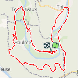
Randonnée Marche de 15,3 km à découvrir à Grand Est, Ardennes, Haulmé. Cette randonnée est proposée par tracegps.
Description
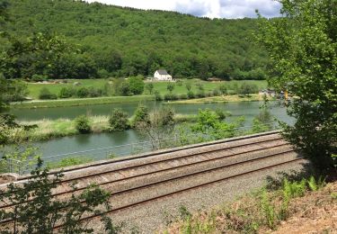
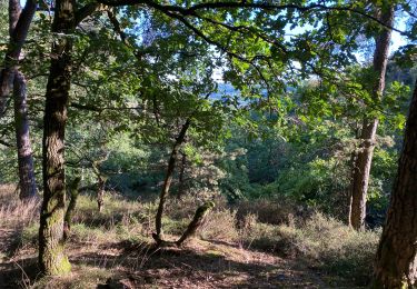
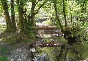
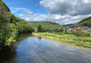
Boucle faite à pied mais qui pourrait être faite à VTT dans le sens antihorlogique de préférence (chemin de descente sur Navaux difficile). Agréables paysages variés, le long de la Semois (Semoy). Démarrage possible dans les 3 villages.
Localisation
Pays :
France
Région :
Grand Est
Département/Province :
Ardennes
Commune :
Haulmé
Localité :
Unknown
Départ:(Dec)
Départ:(UTM)
629476 ; 5524288 (31U) N.
Commentaires
Randonnées à proximité
![Randonnée Marche Monthermé - De Monthermé à Bogny sur Meuse par les sentiers de crêtes - Photo](https://media.geolcdn.com/t/375/260/ext.jpg?maxdim=2&url=https%3A%2F%2Fservices.sitytrail.com%2FGeolivesWS%2FDownloadMedia.ashx%3FTrailID%3D109030%26Media%3D2990_6.jpg)
![Marche Marche](https://static1.geolcdn.com/sitytour/trail-icons/101.png)
De Monthermé à Bogny sur Meuse par les sentiers de crêtes
Marche
Difficile
(2)
Monthermé,
Grand Est,
Ardennes,
France
![](/images/other/stat-length.png)
14,6 km | 23 km-effort
5h 0min
![](https://static1.geolcdn.com/siteimages/upload/files/16400158638029165_repeat_loop_refresh_sync_direction_icon.png)
Oui
![Randonnée Marche Nouzonville - Rando. Nouzonville FFSP - Photo](https://media.geolcdn.com/t/375/260/ext.jpg?maxdim=2&url=https%3A%2F%2Fservices.sitytrail.com%2FGeolivesWS%2FDownloadMedia.ashx%3FTrailID%3D756986%26Media%3D20170521131908.jpg)
![Marche Marche](https://static1.geolcdn.com/sitytour/trail-icons/101.png)
Rando. Nouzonville FFSP
Marche
Moyen
(1)
Nouzonville,
Grand Est,
Ardennes,
France
![](/images/other/stat-length.png)
15,9 km | 21 km-effort
3h 55min
![](https://static1.geolcdn.com/siteimages/upload/files/16400158638029165_repeat_loop_refresh_sync_direction_icon.png)
Oui
![Randonnée Marche Bogny-sur-Meuse - La promenade du Liry et des Quatre Fils Aymon - Photo](https://media.geolcdn.com/t/375/260/ext.jpg?maxdim=2&url=https%3A%2F%2Fstatic1.geolcdn.com%2Fsiteimages%2Fupload%2Ffiles%2F1553511878bg_sport_marche.png)
![Marche Marche](https://static1.geolcdn.com/sitytour/trail-icons/101.png)
La promenade du Liry et des Quatre Fils Aymon
Marche
Moyen
(1)
Bogny-sur-Meuse,
Grand Est,
Ardennes,
France
![](/images/other/stat-length.png)
11,4 km | 16,9 km-effort
3h 0min
![](https://static1.geolcdn.com/siteimages/upload/files/16400158638029165_repeat_loop_refresh_sync_direction_icon.png)
Oui
![Randonnée Marche Les Hautes-Rivières - Hautes Rivières Roches aux Corpias 24,8 - Photo](https://media.geolcdn.com/t/375/260/1bced7d6-1689-4307-97c5-abccba35c800.jpg&format=jpg&maxdim=2)
![Marche Marche](https://static1.geolcdn.com/sitytour/trail-icons/101.png)
Hautes Rivières Roches aux Corpias 24,8
Marche
Difficile
Les Hautes-Rivières,
Grand Est,
Ardennes,
France
![](/images/other/stat-length.png)
25 km | 39 km-effort
8h 34min
![](https://static1.geolcdn.com/siteimages/upload/files/16400158638029165_repeat_loop_refresh_sync_direction_icon.png)
Oui
![Randonnée A pied Vresse-sur-Semois - Les Dolimarts - Photo](https://media.geolcdn.com/t/375/260/ext.jpg?maxdim=2&url=https%3A%2F%2Fpivotmedia.tourismewallonie.be%2FOTH-A0-005T-1NO4%2FOTH-A0-005T-1NO4.jpg)
![A pied A pied](https://static1.geolcdn.com/sitytour/trail-icons/100.png)
Les Dolimarts
A pied
Facile
Vresse-sur-Semois,
Wallonie,
Namur,
Belgique
![](/images/other/stat-length.png)
4,2 km | 6,4 km-effort
1h 27min
![](https://static1.geolcdn.com/siteimages/upload/files/16400158638029165_repeat_loop_refresh_sync_direction_icon.png)
Oui
![Randonnée Autre activité Nouzonville - Balade VTT sympa - Photo](https://media.geolcdn.com/t/375/260/ext.jpg?maxdim=2&url=https%3A%2F%2Fstatic1.geolcdn.com%2Fsiteimages%2Fupload%2Ffiles%2F1545311037marcheuse_200dpi.jpg)
![Autre activité Autre activité](https://static1.geolcdn.com/sitytour/trail-icons/900.png)
Balade VTT sympa
Autre activité
Facile
(1)
Nouzonville,
Grand Est,
Ardennes,
France
![](/images/other/stat-length.png)
11,7 km | 13,8 km-effort
1h 18min
![](https://static1.geolcdn.com/siteimages/upload/files/16400158638029165_repeat_loop_refresh_sync_direction_icon.png)
Oui
![Randonnée Marche Gespunsart - Gespunsart 110324 - Photo](https://media.geolcdn.com/t/375/260/983592c9-ed59-484b-ab3f-739543686869.jpg&format=jpg&maxdim=2)
![Marche Marche](https://static1.geolcdn.com/sitytour/trail-icons/101.png)
Gespunsart 110324
Marche
Moyen
Gespunsart,
Grand Est,
Ardennes,
France
![](/images/other/stat-length.png)
19 km | 24 km-effort
4h 17min
![](https://static1.geolcdn.com/siteimages/upload/files/16400158638029165_repeat_loop_refresh_sync_direction_icon.png)
Oui
![Randonnée Marche Monthermé - La roche 7H Monthermé - Photo](https://media.geolcdn.com/t/375/260/9f5bae53-ca7e-45f9-9b5d-eda45fb0ca79.jpg&format=jpg&maxdim=2)
![Marche Marche](https://static1.geolcdn.com/sitytour/trail-icons/101.png)
La roche 7H Monthermé
Marche
Moyen
Monthermé,
Grand Est,
Ardennes,
France
![](/images/other/stat-length.png)
5,9 km | 9 km-effort
2h 24min
![](https://static1.geolcdn.com/siteimages/upload/files/16400158638029165_repeat_loop_refresh_sync_direction_icon.png)
Oui
![Randonnée Marche Les Hautes-Rivières - Hautes Rivières Naux retour 13 Km - Photo](https://media.geolcdn.com/t/375/260/23b1285b-93b6-4327-95c5-595b3e3e7475.jpg&format=jpg&maxdim=2)
![Marche Marche](https://static1.geolcdn.com/sitytour/trail-icons/101.png)
Hautes Rivières Naux retour 13 Km
Marche
Moyen
Les Hautes-Rivières,
Grand Est,
Ardennes,
France
![](/images/other/stat-length.png)
13,7 km | 19,6 km-effort
4h 0min
![](https://static1.geolcdn.com/siteimages/upload/files/16400158638029165_repeat_loop_refresh_sync_direction_icon.png)
Oui
Balade sympa