![](/images/other/stat-length.png)
![Randonnée Marche Donnezac - Donnezac V2 - Photo](https://media.geolcdn.com/t/1900/400/ext.pjpeg?maxdim=2&url=https%3A%2F%2Fstatic1.geolcdn.com%2Fsiteimages%2Fupload%2Ffiles%2F1553511878bg_sport_marche.png)
Donnezac V2
Rosko65
Utilisateur
![Longueur](/images/other/stat-length.png)
Longueur
18,5 km
![Altitude max](https://static1.geolcdn.com/siteimages/upload/files/1508320355ic_sort_altitude_max_24dp.png)
Altitude max
80 m
![Dénivelé positif](https://static1.geolcdn.com/siteimages/upload/files/1508320355ic_sort_den_pos_24dp.png)
Dénivelé positif
128 m
![Km-Effort](/images/other/stat-length.png)
Km-Effort
20 km
![Altitude min](https://static1.geolcdn.com/siteimages/upload/files/1508320355ic_sort_altitude_min_24dp.png)
Altitude min
46 m
![Dénivelé négatif](https://static1.geolcdn.com/siteimages/upload/files/1508320355ic_sort_den_neg_24dp.png)
Dénivelé négatif
129 m
![Boucle](https://static1.geolcdn.com/siteimages/upload/files/16400158638029165_repeat_loop_refresh_sync_direction_icon.png)
Boucle
Oui
Date de création :
2019-07-21 07:56:57.742
Dernière modification :
2019-08-23 09:18:44.026
![Marche](https://static1.geolcdn.com/sitytour/trail-icons/101.png)
4h31
Difficulté : Facile
![Scannez ce code QR pour ouvrir la randonnée dans l'application SityTrail](https://capi.geolives.com/qq0zvz2zws4bq2lad0pu/sitytour/trails/2146724/qr.png?size=200)
Application GPS de randonnée GRATUITE
À propos
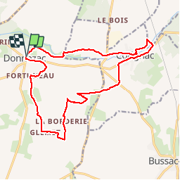
Randonnée Marche de 18,5 km à découvrir à Nouvelle-Aquitaine, Gironde, Donnezac. Cette randonnée est proposée par Rosko65.
Description
Rando parmi pins et feuillus à la limite Gironde-Charente maritime. Découverte de Corignac et Donnezac et du petit ruisseau de la Livenne.
Localisation
Pays :
France
Région :
Nouvelle-Aquitaine
Département/Province :
Gironde
Commune :
Donnezac
Localité :
Unknown
Départ:(Dec)
Départ:(UTM)
700663 ; 5013762 (30T) N.
Commentaires
Randonnées à proximité
![Randonnée V.T.T. Montendre - montendre , chepniers - Photo](https://media.geolcdn.com/t/375/260/8d941acf-48ef-442d-9ddd-58ebba1148c4.jpg&format=jpg&maxdim=2)
![V.T.T. V.T.T.](https://static1.geolcdn.com/sitytour/trail-icons/202.png)
montendre , chepniers
V.T.T.
Très difficile
Montendre,
Nouvelle-Aquitaine,
Charente-Maritime,
France
![](/images/other/stat-length.png)
40 km | 45 km-effort
4h 23min
![](https://static1.geolcdn.com/siteimages/upload/files/16400158638029165_repeat_loop_refresh_sync_direction_icon.png)
Non
![Randonnée V.T.T. Montendre - Randonnée Montendre 2012 - Photo](https://media.geolcdn.com/t/375/260/ext.jpg?maxdim=2&url=https%3A%2F%2Fservices.sitytrail.com%2FGeolivesWS%2FDownloadMedia.ashx%3FTrailID%3D129616%26Media%3D13134_3.jpg)
![V.T.T. V.T.T.](https://static1.geolcdn.com/sitytour/trail-icons/202.png)
Randonnée Montendre 2012
V.T.T.
Moyen
Montendre,
Nouvelle-Aquitaine,
Charente-Maritime,
France
![](/images/other/stat-length.png)
39 km | 44 km-effort
2h 30min
![](https://static1.geolcdn.com/siteimages/upload/files/16400158638029165_repeat_loop_refresh_sync_direction_icon.png)
Oui
![Randonnée Marche Reignac - Marcillac 21km - Photo](https://media.geolcdn.com/t/375/260/ext.jpg?maxdim=2&url=https%3A%2F%2Fstatic1.geolcdn.com%2Fsiteimages%2Fupload%2Ffiles%2F1553511878bg_sport_marche.png)
![Marche Marche](https://static1.geolcdn.com/sitytour/trail-icons/101.png)
Marcillac 21km
Marche
Moyen
Reignac,
Nouvelle-Aquitaine,
Gironde,
France
![](/images/other/stat-length.png)
21 km | 23 km-effort
5h 10min
![](https://static1.geolcdn.com/siteimages/upload/files/16400158638029165_repeat_loop_refresh_sync_direction_icon.png)
Oui
![Randonnée Marche Reignac - rando la chapelle reignac - Photo](https://media.geolcdn.com/t/375/260/ext.jpg?maxdim=2&url=https%3A%2F%2Fstatic1.geolcdn.com%2Fsiteimages%2Fupload%2Ffiles%2F1553511878bg_sport_marche.png)
![Marche Marche](https://static1.geolcdn.com/sitytour/trail-icons/101.png)
rando la chapelle reignac
Marche
Très facile
Reignac,
Nouvelle-Aquitaine,
Gironde,
France
![](/images/other/stat-length.png)
4,6 km | 5 km-effort
1h 53min
![](https://static1.geolcdn.com/siteimages/upload/files/16400158638029165_repeat_loop_refresh_sync_direction_icon.png)
Oui
![Randonnée Marche Montendre - mo´y68i - Photo](https://media.geolcdn.com/t/375/260/ext.jpg?maxdim=2&url=https%3A%2F%2Fstatic1.geolcdn.com%2Fsiteimages%2Fupload%2Ffiles%2F1553511878bg_sport_marche.png)
![Marche Marche](https://static1.geolcdn.com/sitytour/trail-icons/101.png)
mo´y68i
Marche
Facile
Montendre,
Nouvelle-Aquitaine,
Charente-Maritime,
France
![](/images/other/stat-length.png)
5,1 km | 5,7 km-effort
1h 49min
![](https://static1.geolcdn.com/siteimages/upload/files/16400158638029165_repeat_loop_refresh_sync_direction_icon.png)
Oui
![Randonnée Marche Montendre - mt02 - Photo](https://media.geolcdn.com/t/375/260/ext.jpg?maxdim=2&url=https%3A%2F%2Fstatic1.geolcdn.com%2Fsiteimages%2Fupload%2Ffiles%2F1553511878bg_sport_marche.png)
![Marche Marche](https://static1.geolcdn.com/sitytour/trail-icons/101.png)
mt02
Marche
Moyen
Montendre,
Nouvelle-Aquitaine,
Charente-Maritime,
France
![](/images/other/stat-length.png)
5,7 km | 6,6 km-effort
1h 37min
![](https://static1.geolcdn.com/siteimages/upload/files/16400158638029165_repeat_loop_refresh_sync_direction_icon.png)
Oui
![Randonnée Marche Montendre - montendre - Photo](https://media.geolcdn.com/t/375/260/ext.jpg?maxdim=2&url=https%3A%2F%2Fstatic1.geolcdn.com%2Fsiteimages%2Fupload%2Ffiles%2F1553511878bg_sport_marche.png)
![Marche Marche](https://static1.geolcdn.com/sitytour/trail-icons/101.png)
montendre
Marche
Facile
Montendre,
Nouvelle-Aquitaine,
Charente-Maritime,
France
![](/images/other/stat-length.png)
2,1 km | 2,3 km-effort
51min
![](https://static1.geolcdn.com/siteimages/upload/files/16400158638029165_repeat_loop_refresh_sync_direction_icon.png)
Oui
![Randonnée Marche Reignac - Menant eau les Chaumes - Photo](https://media.geolcdn.com/t/375/260/ext.jpg?maxdim=2&url=https%3A%2F%2Fstatic1.geolcdn.com%2Fsiteimages%2Fupload%2Ffiles%2F1553511878bg_sport_marche.png)
![Marche Marche](https://static1.geolcdn.com/sitytour/trail-icons/101.png)
Menant eau les Chaumes
Marche
Facile
Reignac,
Nouvelle-Aquitaine,
Gironde,
France
![](/images/other/stat-length.png)
11,4 km | 12,8 km-effort
2h 45min
![](https://static1.geolcdn.com/siteimages/upload/files/16400158638029165_repeat_loop_refresh_sync_direction_icon.png)
Oui
![Randonnée Marche Montendre - Caprando 17 Montendre - Photo](https://media.geolcdn.com/t/375/260/ext.jpg?maxdim=2&url=https%3A%2F%2Fstatic1.geolcdn.com%2Fsiteimages%2Fupload%2Ffiles%2F1553511878bg_sport_marche.png)
![Marche Marche](https://static1.geolcdn.com/sitytour/trail-icons/101.png)
Caprando 17 Montendre
Marche
Très facile
Montendre,
Nouvelle-Aquitaine,
Charente-Maritime,
France
![](/images/other/stat-length.png)
11,3 km | 12,3 km-effort
2h 46min
![](https://static1.geolcdn.com/siteimages/upload/files/16400158638029165_repeat_loop_refresh_sync_direction_icon.png)
Oui