![](/images/other/stat-length.png)
![Randonnée Marche Gouaux-de-Luchon - Pic de Burat en boucle - Photo](https://media.geolcdn.com/t/1900/400/ext.pjpeg?maxdim=2&url=https%3A%2F%2Fstatic1.geolcdn.com%2Fsiteimages%2Fupload%2Ffiles%2F1553511878bg_sport_marche.png)
Pic de Burat en boucle
chrisgps
Utilisateur
![Longueur](/images/other/stat-length.png)
![Altitude max](https://static1.geolcdn.com/siteimages/upload/files/1508320355ic_sort_altitude_max_24dp.png)
![Dénivelé positif](https://static1.geolcdn.com/siteimages/upload/files/1508320355ic_sort_den_pos_24dp.png)
![Km-Effort](/images/other/stat-length.png)
![Altitude min](https://static1.geolcdn.com/siteimages/upload/files/1508320355ic_sort_altitude_min_24dp.png)
![Dénivelé négatif](https://static1.geolcdn.com/siteimages/upload/files/1508320355ic_sort_den_neg_24dp.png)
![Boucle](https://static1.geolcdn.com/siteimages/upload/files/16400158638029165_repeat_loop_refresh_sync_direction_icon.png)
![Marche](https://static1.geolcdn.com/sitytour/trail-icons/101.png)
7h21
Difficulté : Difficile
![Scannez ce code QR pour ouvrir la randonnée dans l'application SityTrail](https://capi.geolives.com/qq0zvz2zws4bq2lad0pu/sitytour/trails/2143902/qr.png?size=200)
Application GPS de randonnée GRATUITE
À propos
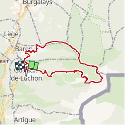
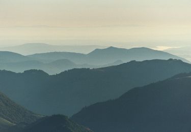
Randonnée Marche de 17,5 km à découvrir à Occitanie, Haute-Garonne, Gouaux-de-Luchon. Cette randonnée est proposée par chrisgps.
Description
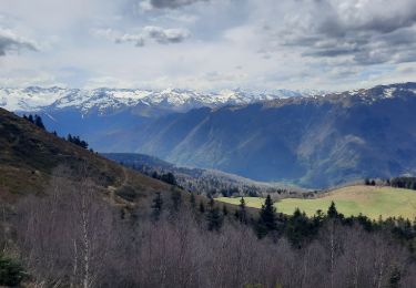
au départ de Gouhaux de Luchon. Passage aux cabanes de Salode & Sarrouegère et entre les 2 étangs au dessus. Accès à la crête de Cigalère avant d'arriver au Pic de Burat. Superbe panorama.
Déscente en crête sur une sente assez marquée et sans réelle difficulté jusqu'au Pic de Maupas. La sente se poursuit jusqu'à la cabane de Planet . De là la pabane de Plagnette est en vue en contre bas.On retrouve là le sentier balisé descendant vers Baren que l'on quittera vers 910 pour prendre le GR86 (indication : cabane de Baren et un peu plus loin Gouhaut de Luchon)menant par une longue transversale au village du départ
Localisation
Commentaires
Randonnées à proximité
![Randonnée Marche Saccourvielle - Cap de Salières en boucle depuis Saccourvielle - Photo](https://media.geolcdn.com/t/375/260/9067fbef-09d4-4f17-8717-9e32e9492c01.jpg&format=jpg&maxdim=2)
![Marche Marche](https://static1.geolcdn.com/sitytour/trail-icons/101.png)
Marche
![](/images/other/stat-length.png)
![](https://static1.geolcdn.com/siteimages/upload/files/16400158638029165_repeat_loop_refresh_sync_direction_icon.png)
![Randonnée Marche Baren - mail de la Pique 01 2018 - Photo](https://media.geolcdn.com/t/375/260/ext.jpg?maxdim=2&url=https%3A%2F%2Fservices.sitytrail.com%2FGeolivesWS%2FDownloadMedia.ashx%3FTrailID%3D893844%26Media%3Dfix__20180118101934.jpg)
![Marche Marche](https://static1.geolcdn.com/sitytour/trail-icons/101.png)
Marche
![](/images/other/stat-length.png)
![](https://static1.geolcdn.com/siteimages/upload/files/16400158638029165_repeat_loop_refresh_sync_direction_icon.png)
![Randonnée Marche Artigue - ARTIGUE - Gouaux de Luchon - chemin forestier - Photo](https://media.geolcdn.com/t/375/260/ext.jpg?maxdim=2&url=https%3A%2F%2Fstatic1.geolcdn.com%2Fsiteimages%2Fupload%2Ffiles%2F1553511878bg_sport_marche.png)
![Marche Marche](https://static1.geolcdn.com/sitytour/trail-icons/101.png)
Marche
![](/images/other/stat-length.png)
![](https://static1.geolcdn.com/siteimages/upload/files/16400158638029165_repeat_loop_refresh_sync_direction_icon.png)
![Randonnée Marche Artigue - Artigue pic de Bacanere - Photo](https://media.geolcdn.com/t/375/260/0674b2f2-ba98-48ee-8365-d627d97b03e5.jpg&format=jpg&maxdim=2)
![Marche Marche](https://static1.geolcdn.com/sitytour/trail-icons/101.png)
Marche
![](/images/other/stat-length.png)
![](https://static1.geolcdn.com/siteimages/upload/files/16400158638029165_repeat_loop_refresh_sync_direction_icon.png)
![Randonnée Marche Sode - cabane de Plan Pouné, par refuge de Cualot - Photo](https://media.geolcdn.com/t/375/260/36e8fbb1-a132-4062-9b5e-14952719d757.jpg&format=jpg&maxdim=2)
![Marche Marche](https://static1.geolcdn.com/sitytour/trail-icons/101.png)
Marche
![](/images/other/stat-length.png)
![](https://static1.geolcdn.com/siteimages/upload/files/16400158638029165_repeat_loop_refresh_sync_direction_icon.png)
![Randonnée Marche Artigue - Artigue par la cabane du plan Bosc et la cabane de Saunères - Photo](https://media.geolcdn.com/t/375/260/3c7be430-12b7-4318-be61-25352c65f0e4.jpg&format=jpg&maxdim=2)
![Marche Marche](https://static1.geolcdn.com/sitytour/trail-icons/101.png)
Marche
![](/images/other/stat-length.png)
![](https://static1.geolcdn.com/siteimages/upload/files/16400158638029165_repeat_loop_refresh_sync_direction_icon.png)
![Randonnée Marche Baren - Mail de la Pique depuis Baren - Photo](https://media.geolcdn.com/t/375/260/574d7441-59c2-4f23-a4a5-6c5993228bb5.jpg&format=jpg&maxdim=2)
![Marche Marche](https://static1.geolcdn.com/sitytour/trail-icons/101.png)
Marche
![](/images/other/stat-length.png)
![](https://static1.geolcdn.com/siteimages/upload/files/16400158638029165_repeat_loop_refresh_sync_direction_icon.png)
![Randonnée Marche Artigue - 2022-02-26 Artigue - cabane de peyrehitte - mont Majou - luchonais - Photo](https://media.geolcdn.com/t/375/260/d3d7c3f2-a654-4693-9bbc-04b518c9f33d.jpg&format=jpg&maxdim=2)
![Marche Marche](https://static1.geolcdn.com/sitytour/trail-icons/101.png)
Marche
![](/images/other/stat-length.png)
![](https://static1.geolcdn.com/siteimages/upload/files/16400158638029165_repeat_loop_refresh_sync_direction_icon.png)
![Randonnée A pied Artigue - Pic de Bacanère - Photo](https://media.geolcdn.com/t/375/260/d3d1e888-9968-464e-9026-b2d9b302e4f2.jpeg&format=jpg&maxdim=2)
![A pied A pied](https://static1.geolcdn.com/sitytour/trail-icons/100.png)
A pied
![](/images/other/stat-length.png)
![](https://static1.geolcdn.com/siteimages/upload/files/16400158638029165_repeat_loop_refresh_sync_direction_icon.png)