![](/images/other/stat-length.png)
![Randonnée Marche Plogoff - la pointe du Raz - Photo](https://media.geolcdn.com/t/1900/400/106b0dee-166f-4747-926b-7aeac04a59f3.jpg&format=pjpeg&maxdim=2)
la pointe du Raz
amiral13
Utilisateur GUIDE
![Longueur](/images/other/stat-length.png)
Longueur
5,3 km
![Altitude max](https://static1.geolcdn.com/siteimages/upload/files/1508320355ic_sort_altitude_max_24dp.png)
Altitude max
71 m
![Dénivelé positif](https://static1.geolcdn.com/siteimages/upload/files/1508320355ic_sort_den_pos_24dp.png)
Dénivelé positif
132 m
![Km-Effort](/images/other/stat-length.png)
Km-Effort
7 km
![Altitude min](https://static1.geolcdn.com/siteimages/upload/files/1508320355ic_sort_altitude_min_24dp.png)
Altitude min
7 m
![Dénivelé négatif](https://static1.geolcdn.com/siteimages/upload/files/1508320355ic_sort_den_neg_24dp.png)
Dénivelé négatif
131 m
![Boucle](https://static1.geolcdn.com/siteimages/upload/files/16400158638029165_repeat_loop_refresh_sync_direction_icon.png)
Boucle
Oui
Date de création :
2019-07-15 10:22:30.335
Dernière modification :
2019-08-05 15:30:09.75
![Marche](https://static1.geolcdn.com/sitytour/trail-icons/101.png)
2h56
Difficulté : Difficile
![Scannez ce code QR pour ouvrir la randonnée dans l'application SityTrail](https://capi.geolives.com/qq0zvz2zws4bq2lad0pu/sitytour/trails/2140928/qr.png?size=200)
Application GPS de randonnée GRATUITE
À propos
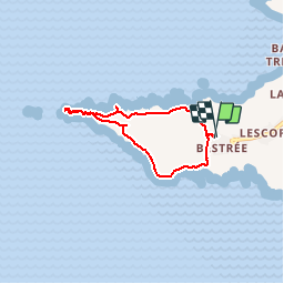
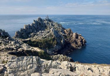
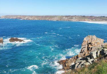
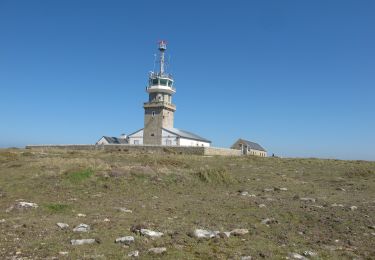
Randonnée Marche de 5,3 km à découvrir à Bretagne, Finistère, Plogoff. Cette randonnée est proposée par amiral13.
Description
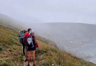
attention après le belvédère officiel un sentier difficile mène jusqu'à la pointe (utilisation des mains nécessaire par endroit) à vos risques et périls. A proscrire les jours de mauvais temps.
Localisation
Pays :
France
Région :
Bretagne
Département/Province :
Finistère
Commune :
Plogoff
Localité :
Unknown
Départ:(Dec)
Départ:(UTM)
371971 ; 5321881 (30U) N.
Commentaires
Randonnées à proximité
![Randonnée Marche Cléden-Cap-Sizun - GR34 Pointe de Brézelec -- Cléden-Cap-Sizun (Pointe du Raz) - Photo](https://media.geolcdn.com/t/375/260/c8e4b333-f389-409b-a569-fa6f65a7aa66.jpg&format=jpg&maxdim=2)
![Marche Marche](https://static1.geolcdn.com/sitytour/trail-icons/101.png)
GR34 Pointe de Brézelec -- Cléden-Cap-Sizun (Pointe du Raz)
Marche
Très difficile
Cléden-Cap-Sizun,
Bretagne,
Finistère,
France
![](/images/other/stat-length.png)
23 km | 30 km-effort
6h 54min
![](https://static1.geolcdn.com/siteimages/upload/files/16400158638029165_repeat_loop_refresh_sync_direction_icon.png)
Non
![Randonnée Marche Plogoff - TREK RCY GR34 J4 2022 Pointe du Raz/ baie des trépassés - Photo](https://media.geolcdn.com/t/375/260/5d2c6731-b703-4e85-be24-5e5d9a1ced82.jpg&format=jpg&maxdim=2)
![Marche Marche](https://static1.geolcdn.com/sitytour/trail-icons/101.png)
TREK RCY GR34 J4 2022 Pointe du Raz/ baie des trépassés
Marche
Facile
Plogoff,
Bretagne,
Finistère,
France
![](/images/other/stat-length.png)
13,9 km | 18,3 km-effort
3h 42min
![](https://static1.geolcdn.com/siteimages/upload/files/16400158638029165_repeat_loop_refresh_sync_direction_icon.png)
Non
![Randonnée Marche Cléden-Cap-Sizun - Pointe du Van - Pointe du Raz par le GR34 - 13.5km 310m 4h10 (40mn) - 2019 09 04 - Photo](https://media.geolcdn.com/t/375/260/06129bcd-1428-4839-9879-17e65208fdf9.jpg&format=jpg&maxdim=2)
![Marche Marche](https://static1.geolcdn.com/sitytour/trail-icons/101.png)
Pointe du Van - Pointe du Raz par le GR34 - 13.5km 310m 4h10 (40mn) - 2019 09 04
Marche
Moyen
Cléden-Cap-Sizun,
Bretagne,
Finistère,
France
![](/images/other/stat-length.png)
13,5 km | 17,6 km-effort
4h 10min
![](https://static1.geolcdn.com/siteimages/upload/files/16400158638029165_repeat_loop_refresh_sync_direction_icon.png)
Oui
![Randonnée Marche Plogoff - plogoff loual - Photo](https://media.geolcdn.com/t/375/260/ext.jpg?maxdim=2&url=https%3A%2F%2Fstatic1.geolcdn.com%2Fsiteimages%2Fupload%2Ffiles%2F1553511878bg_sport_marche.png)
![Marche Marche](https://static1.geolcdn.com/sitytour/trail-icons/101.png)
plogoff loual
Marche
Facile
(1)
Plogoff,
Bretagne,
Finistère,
France
![](/images/other/stat-length.png)
4,1 km | 5 km-effort
1h 8min
![](https://static1.geolcdn.com/siteimages/upload/files/16400158638029165_repeat_loop_refresh_sync_direction_icon.png)
Oui
![Randonnée Marche Plogoff - la pointe du raz Bretagne - Photo](https://media.geolcdn.com/t/375/260/ext.jpg?maxdim=2&url=https%3A%2F%2Fstatic1.geolcdn.com%2Fsiteimages%2Fupload%2Ffiles%2F1553511878bg_sport_marche.png)
![Marche Marche](https://static1.geolcdn.com/sitytour/trail-icons/101.png)
la pointe du raz Bretagne
Marche
Très facile
(1)
Plogoff,
Bretagne,
Finistère,
France
![](/images/other/stat-length.png)
6,8 km | 9 km-effort
2h 19min
![](https://static1.geolcdn.com/siteimages/upload/files/16400158638029165_repeat_loop_refresh_sync_direction_icon.png)
Oui
![Randonnée Marche Cléden-Cap-Sizun - point du van - Photo](https://media.geolcdn.com/t/375/260/ext.jpg?maxdim=2&url=https%3A%2F%2Fstatic1.geolcdn.com%2Fsiteimages%2Fupload%2Ffiles%2F1553511878bg_sport_marche.png)
![Marche Marche](https://static1.geolcdn.com/sitytour/trail-icons/101.png)
point du van
Marche
Moyen
(1)
Cléden-Cap-Sizun,
Bretagne,
Finistère,
France
![](/images/other/stat-length.png)
10,6 km | 13,9 km-effort
Inconnu
![](https://static1.geolcdn.com/siteimages/upload/files/16400158638029165_repeat_loop_refresh_sync_direction_icon.png)
Oui
![Randonnée Marche Cléden-Cap-Sizun - POINTE DU RAZ - Photo](https://media.geolcdn.com/t/375/260/50bf8e99-98ae-4340-8c1b-eb502686b93f.jpg&format=jpg&maxdim=2)
![Marche Marche](https://static1.geolcdn.com/sitytour/trail-icons/101.png)
POINTE DU RAZ
Marche
Facile
Cléden-Cap-Sizun,
Bretagne,
Finistère,
France
![](/images/other/stat-length.png)
15,7 km | 20 km-effort
4h 38min
![](https://static1.geolcdn.com/siteimages/upload/files/16400158638029165_repeat_loop_refresh_sync_direction_icon.png)
Oui
![Randonnée Marche Plogoff - pointe du Raz - Photo](https://media.geolcdn.com/t/375/260/f0356271-982d-47aa-a59e-15ed79828940.jpg&format=jpg&maxdim=2)
![Marche Marche](https://static1.geolcdn.com/sitytour/trail-icons/101.png)
![Randonnée A pied Plogoff - Circuit de la Pointe du Raz - Photo](https://media.geolcdn.com/t/375/260/cfdf131d-62e2-4c50-8c6c-90ebd1a764c6.jpeg&format=jpg&maxdim=2)
![A pied A pied](https://static1.geolcdn.com/sitytour/trail-icons/100.png)
Circuit de la Pointe du Raz
A pied
Facile
(1)
Plogoff,
Bretagne,
Finistère,
France
![](/images/other/stat-length.png)
8,8 km | 11,8 km-effort
2h 40min
![](https://static1.geolcdn.com/siteimages/upload/files/16400158638029165_repeat_loop_refresh_sync_direction_icon.png)
Oui