![](/images/other/stat-length.png)
![Randonnée V.T.T. Barcillonnette - tour de la montagne d'Aujour - Photo](https://media.geolcdn.com/t/1900/400/ext.pjpeg?maxdim=2&url=https%3A%2F%2Fstatic1.geolcdn.com%2Fsiteimages%2Fupload%2Ffiles%2F1524743154velo.jpg)
tour de la montagne d'Aujour
slafont0
Utilisateur
![Longueur](/images/other/stat-length.png)
Longueur
56 km
![Altitude max](https://static1.geolcdn.com/siteimages/upload/files/1508320355ic_sort_altitude_max_24dp.png)
Altitude max
1422 m
![Dénivelé positif](https://static1.geolcdn.com/siteimages/upload/files/1508320355ic_sort_den_pos_24dp.png)
Dénivelé positif
1745 m
![Km-Effort](/images/other/stat-length.png)
Km-Effort
79 km
![Altitude min](https://static1.geolcdn.com/siteimages/upload/files/1508320355ic_sort_altitude_min_24dp.png)
Altitude min
683 m
![Dénivelé négatif](https://static1.geolcdn.com/siteimages/upload/files/1508320355ic_sort_den_neg_24dp.png)
Dénivelé négatif
1735 m
![Boucle](https://static1.geolcdn.com/siteimages/upload/files/16400158638029165_repeat_loop_refresh_sync_direction_icon.png)
Boucle
Oui
Date de création :
2019-07-13 09:22:05.318
Dernière modification :
2019-07-14 16:20:43.432
![V.T.T.](https://static1.geolcdn.com/sitytour/trail-icons/202.png)
9h22
Difficulté : Moyen
![Scannez ce code QR pour ouvrir la randonnée dans l'application SityTrail](https://capi.geolives.com/qq0zvz2zws4bq2lad0pu/sitytour/trails/2140288/qr.png?size=200)
Application GPS de randonnée GRATUITE
À propos
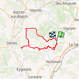
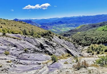
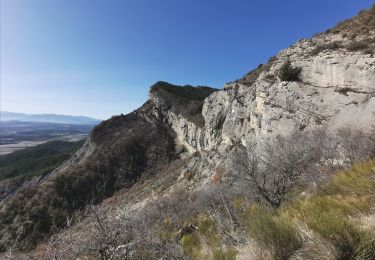
Randonnée V.T.T. de 56 km à découvrir à Provence-Alpes-Côte d'Azur, Hautes-Alpes, Barcillonnette. Cette randonnée est proposée par slafont0.
Description
boucle de 2 jours
depart Barcillonnette
nuit au gite moulin d'aimé
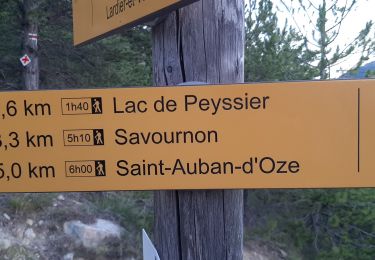
retour par le défilé de Gouravour et lac de peyssier
Localisation
Pays :
France
Région :
Provence-Alpes-Côte d'Azur
Département/Province :
Hautes-Alpes
Commune :
Barcillonnette
Localité :
Unknown
Départ:(Dec)
Départ:(UTM)
732357 ; 4924284 (31T) N.
Commentaires
Randonnées à proximité
![Randonnée Marche Monêtier-Allemont - le pic de Crigne - Photo](https://media.geolcdn.com/t/375/260/3216e3ac-fa23-434c-aac1-d06a9982e5b1.jpg&format=jpg&maxdim=2)
![Marche Marche](https://static1.geolcdn.com/sitytour/trail-icons/101.png)
le pic de Crigne
Marche
Difficile
Monêtier-Allemont,
Provence-Alpes-Côte d'Azur,
Hautes-Alpes,
France
![](/images/other/stat-length.png)
5,6 km | 13,4 km-effort
3h 27min
![](https://static1.geolcdn.com/siteimages/upload/files/16400158638029165_repeat_loop_refresh_sync_direction_icon.png)
Oui
![Randonnée Marche Vitrolles - Pic de Crigne - Photo](https://media.geolcdn.com/t/375/260/8de24f96-abb9-4a59-92c3-86b70c658bb0.jpg&format=jpg&maxdim=2)
![Marche Marche](https://static1.geolcdn.com/sitytour/trail-icons/101.png)
Pic de Crigne
Marche
Moyen
Vitrolles,
Provence-Alpes-Côte d'Azur,
Hautes-Alpes,
France
![](/images/other/stat-length.png)
5,9 km | 14,3 km-effort
3h 14min
![](https://static1.geolcdn.com/siteimages/upload/files/16400158638029165_repeat_loop_refresh_sync_direction_icon.png)
Oui
![Randonnée Marche Ventavon - col des selles vers pic de crigne - Photo](https://media.geolcdn.com/t/375/260/e38de5f2-bcbf-465e-9709-6640d810ac1b.jpg&format=jpg&maxdim=2)
![Marche Marche](https://static1.geolcdn.com/sitytour/trail-icons/101.png)
col des selles vers pic de crigne
Marche
Moyen
Ventavon,
Provence-Alpes-Côte d'Azur,
Hautes-Alpes,
France
![](/images/other/stat-length.png)
8,3 km | 17,3 km-effort
4h 4min
![](https://static1.geolcdn.com/siteimages/upload/files/16400158638029165_repeat_loop_refresh_sync_direction_icon.png)
Oui
![Randonnée Marche Esparron - ESPARON 05 . Lac de Peyssier . Col de Peyssier o s - Photo](https://media.geolcdn.com/t/375/260/0f9bb5cb-cbd8-4244-8a0b-6a9c6c8c6e0b.jpg&format=jpg&maxdim=2)
![Marche Marche](https://static1.geolcdn.com/sitytour/trail-icons/101.png)
ESPARON 05 . Lac de Peyssier . Col de Peyssier o s
Marche
Difficile
Esparron,
Provence-Alpes-Côte d'Azur,
Hautes-Alpes,
France
![](/images/other/stat-length.png)
15,9 km | 25 km-effort
4h 38min
![](https://static1.geolcdn.com/siteimages/upload/files/16400158638029165_repeat_loop_refresh_sync_direction_icon.png)
Oui
![Randonnée Marche Monêtier-Allemont - pic de Crigne - Photo](https://media.geolcdn.com/t/375/260/4385029e-383e-41cf-87d5-306f1333b6ec.jpg&format=jpg&maxdim=2)
![Marche Marche](https://static1.geolcdn.com/sitytour/trail-icons/101.png)
pic de Crigne
Marche
Moyen
Monêtier-Allemont,
Provence-Alpes-Côte d'Azur,
Hautes-Alpes,
France
![](/images/other/stat-length.png)
11,3 km | 23 km-effort
6h 23min
![](https://static1.geolcdn.com/siteimages/upload/files/16400158638029165_repeat_loop_refresh_sync_direction_icon.png)
Oui
![Randonnée Marche Ventavon - VENTAVON lac de Peysier n - Photo](https://media.geolcdn.com/t/375/260/07c33526-230f-4d24-9430-dca2c4faa349.jpg&format=jpg&maxdim=2)
![Marche Marche](https://static1.geolcdn.com/sitytour/trail-icons/101.png)
VENTAVON lac de Peysier n
Marche
Moyen
Ventavon,
Provence-Alpes-Côte d'Azur,
Hautes-Alpes,
France
![](/images/other/stat-length.png)
9,3 km | 16,7 km-effort
2h 53min
![](https://static1.geolcdn.com/siteimages/upload/files/16400158638029165_repeat_loop_refresh_sync_direction_icon.png)
Oui
![Randonnée Marche Vitrolles - Pic de Crigne - Photo](https://media.geolcdn.com/t/375/260/c57ec1d9-7b0a-459e-886f-cd7864baade1.jpg&format=jpg&maxdim=2)
![Marche Marche](https://static1.geolcdn.com/sitytour/trail-icons/101.png)
Pic de Crigne
Marche
Très difficile
Vitrolles,
Provence-Alpes-Côte d'Azur,
Hautes-Alpes,
France
![](/images/other/stat-length.png)
11,6 km | 21 km-effort
5h 33min
![](https://static1.geolcdn.com/siteimages/upload/files/16400158638029165_repeat_loop_refresh_sync_direction_icon.png)
Non
![Randonnée Marche Esparron - Montagne de Rochefort via Esparron - Photo](https://media.geolcdn.com/t/375/260/a9afae64-dc46-4a24-9d5a-88e4f626d203.jpg&format=jpg&maxdim=2)
![Marche Marche](https://static1.geolcdn.com/sitytour/trail-icons/101.png)
Montagne de Rochefort via Esparron
Marche
Très difficile
Esparron,
Provence-Alpes-Côte d'Azur,
Hautes-Alpes,
France
![](/images/other/stat-length.png)
12,6 km | 24 km-effort
6h 12min
![](https://static1.geolcdn.com/siteimages/upload/files/16400158638029165_repeat_loop_refresh_sync_direction_icon.png)
Oui
![Randonnée Marche Monêtier-Allemont - Bergerie basse de Crigne - Photo](https://media.geolcdn.com/t/375/260/e57e7c6e-7b24-471d-a732-1162a0342581.jpg&format=jpg&maxdim=2)
![Marche Marche](https://static1.geolcdn.com/sitytour/trail-icons/101.png)
Bergerie basse de Crigne
Marche
Moyen
Monêtier-Allemont,
Provence-Alpes-Côte d'Azur,
Hautes-Alpes,
France
![](/images/other/stat-length.png)
4 km | 8,9 km-effort
2h 0min
![](https://static1.geolcdn.com/siteimages/upload/files/16400158638029165_repeat_loop_refresh_sync_direction_icon.png)
Oui