![](/images/other/stat-length.png)
![Randonnée Marche Noisy-sur-École - 25 bosses - Photo](https://media.geolcdn.com/t/1900/400/ext.pjpeg?maxdim=2&url=https%3A%2F%2Fstatic1.geolcdn.com%2Fsiteimages%2Fupload%2Ffiles%2F1553511878bg_sport_marche.png)
25 bosses
sebastienu
Utilisateur
![Longueur](/images/other/stat-length.png)
Longueur
12,8 km
![Altitude max](https://static1.geolcdn.com/siteimages/upload/files/1508320355ic_sort_altitude_max_24dp.png)
Altitude max
123 m
![Dénivelé positif](https://static1.geolcdn.com/siteimages/upload/files/1508320355ic_sort_den_pos_24dp.png)
Dénivelé positif
292 m
![Km-Effort](/images/other/stat-length.png)
Km-Effort
16,7 km
![Altitude min](https://static1.geolcdn.com/siteimages/upload/files/1508320355ic_sort_altitude_min_24dp.png)
Altitude min
69 m
![Dénivelé négatif](https://static1.geolcdn.com/siteimages/upload/files/1508320355ic_sort_den_neg_24dp.png)
Dénivelé négatif
290 m
![Boucle](https://static1.geolcdn.com/siteimages/upload/files/16400158638029165_repeat_loop_refresh_sync_direction_icon.png)
Boucle
Non
Date de création :
2019-07-06 04:02:10.493
Dernière modification :
2019-07-06 08:57:43.825
![Marche](https://static1.geolcdn.com/sitytour/trail-icons/101.png)
4h54
Difficulté : Difficile
![Scannez ce code QR pour ouvrir la randonnée dans l'application SityTrail](https://capi.geolives.com/qq0zvz2zws4bq2lad0pu/sitytour/trails/2132307/qr.png?size=200)
Application GPS de randonnée GRATUITE
À propos
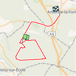
Randonnée Marche de 12,8 km à découvrir à Île-de-France, Seine-et-Marne, Noisy-sur-École. Cette randonnée est proposée par sebastienu.
Description
circuit des 25 bosses en forêt de Fontainebleau. Du parking Croix Saint Jérôme en direction du rochet Guichot. Decrassage en 4h30. Bravo les filles
Localisation
Pays :
France
Région :
Île-de-France
Département/Province :
Seine-et-Marne
Commune :
Noisy-sur-École
Localité :
Unknown
Départ:(Dec)
Départ:(UTM)
464426 ; 5359508 (31U) N.
Commentaires
Randonnées à proximité
![Randonnée Marche Le Vaudoué - Ultra 25 bosses - Photo](https://media.geolcdn.com/t/375/260/ext.jpg?maxdim=2&url=https%3A%2F%2Fservices.sitytrail.com%2FGeolivesWS%2FDownloadMedia.ashx%3FTrailID%3D243413%26Media%3Dfix__20140112104549.jpg)
![Marche Marche](https://static1.geolcdn.com/sitytour/trail-icons/101.png)
Ultra 25 bosses
Marche
Difficile
(1)
Le Vaudoué,
Île-de-France,
Seine-et-Marne,
France
![](/images/other/stat-length.png)
25 km | 32 km-effort
9h 2min
![](https://static1.geolcdn.com/siteimages/upload/files/16400158638029165_repeat_loop_refresh_sync_direction_icon.png)
Oui
![Randonnée Marche Noisy-sur-École - M&R-121118 - 250Marches - Photo](https://media.geolcdn.com/t/375/260/ext.jpg?maxdim=2&url=https%3A%2F%2Fservices.sitytrail.com%2FGeolivesWS%2FDownloadMedia.ashx%3FTrailID%3D163348%26Media%3D20121118101634.jpeg)
![Marche Marche](https://static1.geolcdn.com/sitytour/trail-icons/101.png)
M&R-121118 - 250Marches
Marche
Facile
(1)
Noisy-sur-École,
Île-de-France,
Seine-et-Marne,
France
![](/images/other/stat-length.png)
14,3 km | 18,1 km-effort
3h 50min
![](https://static1.geolcdn.com/siteimages/upload/files/16400158638029165_repeat_loop_refresh_sync_direction_icon.png)
Oui
![Randonnée Marche Milly-la-Forêt - Du parking de la Boulignère aux 100 marches via la ferme des Coquibus - Photo](https://media.geolcdn.com/t/375/260/2d4021ff-70a8-48ff-ad65-d6df60ccba59.jpg&format=jpg&maxdim=2)
![Marche Marche](https://static1.geolcdn.com/sitytour/trail-icons/101.png)
Du parking de la Boulignère aux 100 marches via la ferme des Coquibus
Marche
Difficile
(1)
Milly-la-Forêt,
Île-de-France,
Essonne,
France
![](/images/other/stat-length.png)
18,3 km | 22 km-effort
5h 0min
![](https://static1.geolcdn.com/siteimages/upload/files/16400158638029165_repeat_loop_refresh_sync_direction_icon.png)
Oui
![Randonnée Marche Noisy-sur-École - Bois Rond#4 - Photo](https://media.geolcdn.com/t/375/260/7321184d-880d-445f-98b4-47f0ff0d82dd.jpg&format=jpg&maxdim=2)
![Marche Marche](https://static1.geolcdn.com/sitytour/trail-icons/101.png)
Bois Rond#4
Marche
Très facile
(1)
Noisy-sur-École,
Île-de-France,
Seine-et-Marne,
France
![](/images/other/stat-length.png)
8,8 km | 10,5 km-effort
2h 18min
![](https://static1.geolcdn.com/siteimages/upload/files/16400158638029165_repeat_loop_refresh_sync_direction_icon.png)
Oui
![Randonnée Marche Noisy-sur-École - Les 25 Bosses - Gps en Forêt de Fontainebleau - Photo](https://media.geolcdn.com/t/375/260/ext.jpg?maxdim=2&url=https%3A%2F%2Fservices.sitytrail.com%2FGeolivesWS%2FDownloadMedia.ashx%3FTrailID%3D101528%26Media%3D1630_1.jpg)
![Marche Marche](https://static1.geolcdn.com/sitytour/trail-icons/101.png)
Les 25 Bosses - Gps en Forêt de Fontainebleau
Marche
Très difficile
(2)
Noisy-sur-École,
Île-de-France,
Seine-et-Marne,
France
![](/images/other/stat-length.png)
17,6 km | 23 km-effort
4h 45min
![](https://static1.geolcdn.com/siteimages/upload/files/16400158638029165_repeat_loop_refresh_sync_direction_icon.png)
Oui
![Randonnée A pied Le Vaudoué - Boucle Le Vaudoué - Photo](https://media.geolcdn.com/t/375/260/d05a3ec5-b137-48e5-a689-019375766e60.jpg&format=jpg&maxdim=2)
![A pied A pied](https://static1.geolcdn.com/sitytour/trail-icons/100.png)
Boucle Le Vaudoué
A pied
Moyen
Le Vaudoué,
Île-de-France,
Seine-et-Marne,
France
![](/images/other/stat-length.png)
17,4 km | 21 km-effort
4h 47min
![](https://static1.geolcdn.com/siteimages/upload/files/16400158638029165_repeat_loop_refresh_sync_direction_icon.png)
Oui
![Randonnée Marche Noisy-sur-École - Boucle 24 km Fontainebleau Arbonne - Photo](https://media.geolcdn.com/t/375/260/5aaa62f0-dc57-4770-a77a-231413885a94.jpg&format=jpg&maxdim=2)
![Marche Marche](https://static1.geolcdn.com/sitytour/trail-icons/101.png)
Boucle 24 km Fontainebleau Arbonne
Marche
Facile
Noisy-sur-École,
Île-de-France,
Seine-et-Marne,
France
![](/images/other/stat-length.png)
25 km | 31 km-effort
5h 52min
![](https://static1.geolcdn.com/siteimages/upload/files/16400158638029165_repeat_loop_refresh_sync_direction_icon.png)
Oui
![Randonnée Marche Milly-la-Forêt - Boucle 29 km Milly La Forêt - Le Vaudoué - Tousson - Photo](https://media.geolcdn.com/t/375/260/3058c3db-123e-4ec5-b295-1e7b4c8ce449.jpg&format=jpg&maxdim=2)
![Marche Marche](https://static1.geolcdn.com/sitytour/trail-icons/101.png)
Boucle 29 km Milly La Forêt - Le Vaudoué - Tousson
Marche
Difficile
Milly-la-Forêt,
Île-de-France,
Essonne,
France
![](/images/other/stat-length.png)
29 km | 33 km-effort
5h 56min
![](https://static1.geolcdn.com/siteimages/upload/files/16400158638029165_repeat_loop_refresh_sync_direction_icon.png)
Oui
![Randonnée Marche Noisy-sur-École - Noisy sur Ecole / Coquibus - Photo](https://media.geolcdn.com/t/375/260/9f6ffc55-2cbc-4988-8e49-be93fd15ba38.jpg&format=jpg&maxdim=2)
![Marche Marche](https://static1.geolcdn.com/sitytour/trail-icons/101.png)
Noisy sur Ecole / Coquibus
Marche
Moyen
Noisy-sur-École,
Île-de-France,
Seine-et-Marne,
France
![](/images/other/stat-length.png)
21 km | 26 km-effort
5h 20min
![](https://static1.geolcdn.com/siteimages/upload/files/16400158638029165_repeat_loop_refresh_sync_direction_icon.png)
Oui