![](/images/other/stat-length.png)
![Randonnée Marche Bras - Bras - Photo](https://media.geolcdn.com/t/1900/400/ext.pjpeg?maxdim=2&url=https%3A%2F%2Fstatic1.geolcdn.com%2Fsiteimages%2Fupload%2Ffiles%2F1553511878bg_sport_marche.png)
Bras
brunotrail05
Utilisateur
![Longueur](/images/other/stat-length.png)
Longueur
7,8 km
![Altitude max](https://static1.geolcdn.com/siteimages/upload/files/1508320355ic_sort_altitude_max_24dp.png)
Altitude max
329 m
![Dénivelé positif](https://static1.geolcdn.com/siteimages/upload/files/1508320355ic_sort_den_pos_24dp.png)
Dénivelé positif
133 m
![Km-Effort](/images/other/stat-length.png)
Km-Effort
9,6 km
![Altitude min](https://static1.geolcdn.com/siteimages/upload/files/1508320355ic_sort_altitude_min_24dp.png)
Altitude min
251 m
![Dénivelé négatif](https://static1.geolcdn.com/siteimages/upload/files/1508320355ic_sort_den_neg_24dp.png)
Dénivelé négatif
139 m
![Boucle](https://static1.geolcdn.com/siteimages/upload/files/16400158638029165_repeat_loop_refresh_sync_direction_icon.png)
Boucle
Oui
Date de création :
2014-12-10 00:00:00.0
Dernière modification :
2014-12-10 00:00:00.0
![Marche](https://static1.geolcdn.com/sitytour/trail-icons/101.png)
2h07
Difficulté : Facile
![Scannez ce code QR pour ouvrir la randonnée dans l'application SityTrail](https://capi.geolives.com/qq0zvz2zws4bq2lad0pu/sitytour/trails/212956/qr.png?size=200)
Application GPS de randonnée GRATUITE
À propos
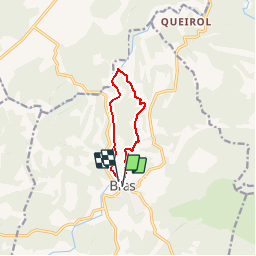
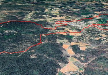
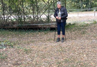
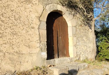
Randonnée Marche de 7,8 km à découvrir à Provence-Alpes-Côte d'Azur, Var, Bras. Cette randonnée est proposée par brunotrail05.
Description
Randonnée pedestre à Bras (facile) de 7.8 km, durant 2h30 avec un dénivelé de 160m. Départ Place Sadi Carnot - balisage jaune puis rouge et blanc
Localisation
Pays :
France
Région :
Provence-Alpes-Côte d'Azur
Département/Province :
Var
Commune :
Bras
Localité :
Unknown
Départ:(Dec)
Départ:(UTM)
738899 ; 4817451 (31T) N.
Commentaires
Randonnées à proximité
![Randonnée Marche Bras - Lavoir - Tour des chapelles - Tour du defend - Photo](https://media.geolcdn.com/t/375/260/47ad5a28-8176-42c0-9d8e-3872979b11bc.jpg&format=jpg&maxdim=2)
![Marche Marche](https://static1.geolcdn.com/sitytour/trail-icons/101.png)
Lavoir - Tour des chapelles - Tour du defend
Marche
Moyen
(1)
Bras,
Provence-Alpes-Côte d'Azur,
Var,
France
![](/images/other/stat-length.png)
14 km | 21 km-effort
6h 0min
![](https://static1.geolcdn.com/siteimages/upload/files/16400158638029165_repeat_loop_refresh_sync_direction_icon.png)
Oui
![Randonnée Marche Bras - Chutes du tombereau - Photo](https://media.geolcdn.com/t/375/260/3ed533da-12d6-4a04-9744-f8536921f316.jpg&format=jpg&maxdim=2)
![Marche Marche](https://static1.geolcdn.com/sitytour/trail-icons/101.png)
Chutes du tombereau
Marche
Facile
(1)
Bras,
Provence-Alpes-Côte d'Azur,
Var,
France
![](/images/other/stat-length.png)
11,1 km | 13,6 km-effort
2h 42min
![](https://static1.geolcdn.com/siteimages/upload/files/16400158638029165_repeat_loop_refresh_sync_direction_icon.png)
Oui
![Randonnée A pied Bras - Chute du Tombereau, Bras 11-10-2024 - Photo](https://media.geolcdn.com/t/375/260/860cd67c-b6a3-4437-878e-156ccdca5542.jpg&format=jpg&maxdim=2)
![A pied A pied](https://static1.geolcdn.com/sitytour/trail-icons/100.png)
Chute du Tombereau, Bras 11-10-2024
A pied
Facile
Bras,
Provence-Alpes-Côte d'Azur,
Var,
France
![](/images/other/stat-length.png)
14,7 km | 18,2 km-effort
4h 8min
![](https://static1.geolcdn.com/siteimages/upload/files/16400158638029165_repeat_loop_refresh_sync_direction_icon.png)
Oui
![Randonnée sport Bras - Bras Martine - Photo](https://media.geolcdn.com/t/375/260/92424973-da8f-45dd-b870-2b8efea2ae3b.jpg&format=jpg&maxdim=2)
Bras Martine
sport
Très facile
(1)
Bras,
Provence-Alpes-Côte d'Azur,
Var,
France
![](/images/other/stat-length.png)
12,3 km | 15,6 km-effort
Inconnu
![](https://static1.geolcdn.com/siteimages/upload/files/16400158638029165_repeat_loop_refresh_sync_direction_icon.png)
Oui
![Randonnée Marche Bras - Bras jeudi 10/02/2022 Martine - Photo](https://media.geolcdn.com/t/375/260/b21c62da-7a83-4fcf-a674-3504e8c67f06.jpg&format=jpg&maxdim=2)
![Marche Marche](https://static1.geolcdn.com/sitytour/trail-icons/101.png)
Bras jeudi 10/02/2022 Martine
Marche
Difficile
Bras,
Provence-Alpes-Côte d'Azur,
Var,
France
![](/images/other/stat-length.png)
15,1 km | 18,3 km-effort
4h 24min
![](https://static1.geolcdn.com/siteimages/upload/files/16400158638029165_repeat_loop_refresh_sync_direction_icon.png)
Non
![Randonnée Marche Bras - Bras - Photo](https://media.geolcdn.com/t/375/260/a7a6d44b-4aa6-4c28-978c-deb3e4b9a501.jpg&format=jpg&maxdim=2)
![Marche Marche](https://static1.geolcdn.com/sitytour/trail-icons/101.png)
Bras
Marche
Facile
(1)
Bras,
Provence-Alpes-Côte d'Azur,
Var,
France
![](/images/other/stat-length.png)
15 km | 18,3 km-effort
3h 33min
![](https://static1.geolcdn.com/siteimages/upload/files/16400158638029165_repeat_loop_refresh_sync_direction_icon.png)
Oui
![Randonnée Marche Bras - 20190414 reco partielle Bras Le Tombereau - Photo](https://media.geolcdn.com/t/375/260/aa3c4189-1fb5-4f4f-b81a-5f04b149b2b5.jpg&format=jpg&maxdim=2)
![Marche Marche](https://static1.geolcdn.com/sitytour/trail-icons/101.png)
20190414 reco partielle Bras Le Tombereau
Marche
Facile
Bras,
Provence-Alpes-Côte d'Azur,
Var,
France
![](/images/other/stat-length.png)
15,5 km | 18,7 km-effort
4h 25min
![](https://static1.geolcdn.com/siteimages/upload/files/16400158638029165_repeat_loop_refresh_sync_direction_icon.png)
Non
![Randonnée Marche Bras - Bras Tombereau - Photo](https://media.geolcdn.com/t/375/260/20416f89-8698-4ee8-b0fd-845273aa1e61.jpg&format=jpg&maxdim=2)
![Marche Marche](https://static1.geolcdn.com/sitytour/trail-icons/101.png)
Bras Tombereau
Marche
Facile
Bras,
Provence-Alpes-Côte d'Azur,
Var,
France
![](/images/other/stat-length.png)
15,8 km | 19 km-effort
3h 30min
![](https://static1.geolcdn.com/siteimages/upload/files/16400158638029165_repeat_loop_refresh_sync_direction_icon.png)
Oui
![Randonnée Marche Bras - Bras reco - Photo](https://media.geolcdn.com/t/375/260/d49c88bf-b8e3-49d9-a838-2bb1359ee89b.jpg&format=jpg&maxdim=2)
![Marche Marche](https://static1.geolcdn.com/sitytour/trail-icons/101.png)
Bras reco
Marche
Facile
Bras,
Provence-Alpes-Côte d'Azur,
Var,
France
![](/images/other/stat-length.png)
14 km | 17,2 km-effort
7h 43min
![](https://static1.geolcdn.com/siteimages/upload/files/16400158638029165_repeat_loop_refresh_sync_direction_icon.png)
Oui
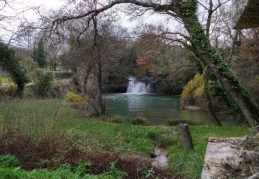
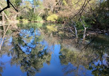
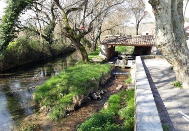
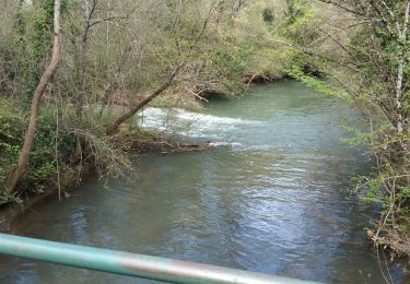
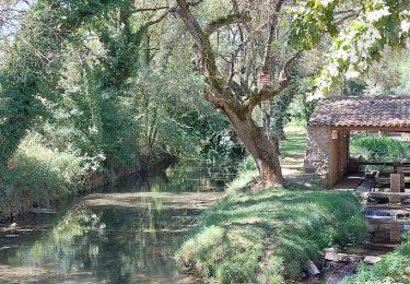
jolie ballade dans la campagne, il manque juste un point de vue