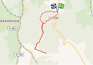
![](/images/other/stat-length.png)
![Randonnée Marche Lauroux - Labeil - Forêt de l'Escandorgue - Photo](https://media.geolcdn.com/t/1900/400/18fff55c-c35a-497a-9322-6bf7e666f623.jpg&format=pjpeg&maxdim=2)
Labeil - Forêt de l'Escandorgue
mdauzat
Utilisateur
![Longueur](/images/other/stat-length.png)
![Altitude max](https://static1.geolcdn.com/siteimages/upload/files/1508320355ic_sort_altitude_max_24dp.png)
![Dénivelé positif](https://static1.geolcdn.com/siteimages/upload/files/1508320355ic_sort_den_pos_24dp.png)
![Km-Effort](/images/other/stat-length.png)
![Altitude min](https://static1.geolcdn.com/siteimages/upload/files/1508320355ic_sort_altitude_min_24dp.png)
![Dénivelé négatif](https://static1.geolcdn.com/siteimages/upload/files/1508320355ic_sort_den_neg_24dp.png)
![Boucle](https://static1.geolcdn.com/siteimages/upload/files/16400158638029165_repeat_loop_refresh_sync_direction_icon.png)
![Marche](https://static1.geolcdn.com/sitytour/trail-icons/101.png)
2h18
Difficulté : Moyen
![Marche nordique](https://static1.geolcdn.com/sitytour/trail-icons/102.png)
2h20
Difficulté : Très facile
![Scannez ce code QR pour ouvrir la randonnée dans l'application SityTrail](https://capi.geolives.com/qq0zvz2zws4bq2lad0pu/sitytour/trails/2124412/qr.png?size=200)
Application GPS de randonnée GRATUITE
À propos
Randonnée Marche de 8 km à découvrir à Occitanie, Hérault, Lauroux. Cette randonnée est proposée par mdauzat.
Description
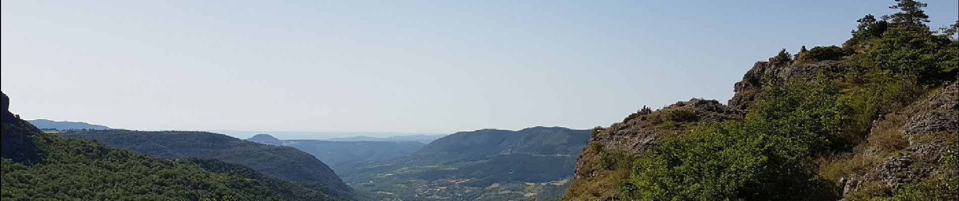
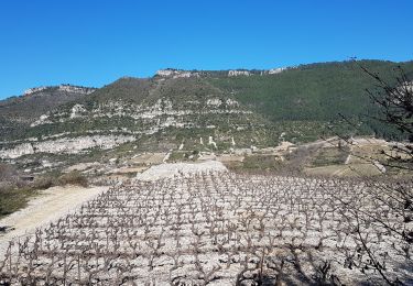
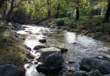
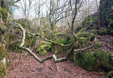
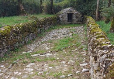
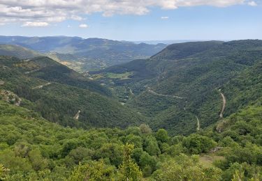
A partir de l'aire de stationnement située au dessus du hameau de Labeil, ce chemin permet de découvrir la forêt de l'Escandorgue, semée d'énormes rochers aux formes extravagantes, couverts de mousse, tandis que, dans le sous-bois, les jeux d'ombre et de lumière créent un décor féérique. On progresse à l'ombre, avec un petit vent frais d'altitude bien agréable par ce jour de canicule, avant d'arriver sur la falaise qui borde le fond du Cirque de Labeil et offre, du haut de la corniche, de splendides points de vue sur la vallée de Lauroux.
Une des plus belles randonnées que l'on puisse imaginer... mais ne le dites à personne !
Localisation
Commentaires
Randonnées à proximité
![Randonnée Marche nordique Lauroux - Labeil - Forêt de l'Escandorgue en marche nordique - Photo](https://media.geolcdn.com/t/375/260/c2282928-f752-4149-927b-0f9ea4e169ca.jpg&format=jpg&maxdim=2)
![Marche nordique Marche nordique](https://static1.geolcdn.com/sitytour/trail-icons/102.png)
Marche nordique
![](/images/other/stat-length.png)
![](https://static1.geolcdn.com/siteimages/upload/files/16400158638029165_repeat_loop_refresh_sync_direction_icon.png)
![Randonnée Marche Les Plans - Forêt domaniale d'Escandorgue par Roqueredonde et l'Engayresque - Photo](https://media.geolcdn.com/t/375/260/c203cd03-9ac1-4e05-8a4c-6b4e6f9317be.jpg&format=jpg&maxdim=2)
![Marche Marche](https://static1.geolcdn.com/sitytour/trail-icons/101.png)
Marche
![](/images/other/stat-length.png)
![](https://static1.geolcdn.com/siteimages/upload/files/16400158638029165_repeat_loop_refresh_sync_direction_icon.png)
![Randonnée Marche Pégairolles-de-l'Escalette - Les terrasses de Pégairolles - Photo](https://media.geolcdn.com/t/375/260/b3cb60db-276e-4d4f-8800-8d2a1afee240.jpg&format=jpg&maxdim=2)
![Marche Marche](https://static1.geolcdn.com/sitytour/trail-icons/101.png)
Marche
![](/images/other/stat-length.png)
![](https://static1.geolcdn.com/siteimages/upload/files/16400158638029165_repeat_loop_refresh_sync_direction_icon.png)
![Randonnée Marche Lauroux - les corniches de lauroux - Photo](https://media.geolcdn.com/t/375/260/ext.jpg?maxdim=2&url=https%3A%2F%2Fservices.sitytrail.com%2FGeolivesWS%2FDownloadMedia.ashx%3FTrailID%3D333456%26Media%3D20140811173610.jpg)
![Marche Marche](https://static1.geolcdn.com/sitytour/trail-icons/101.png)
Marche
![](/images/other/stat-length.png)
![](https://static1.geolcdn.com/siteimages/upload/files/16400158638029165_repeat_loop_refresh_sync_direction_icon.png)
![Randonnée Marche Lauroux - cirque de labeil - Photo](https://media.geolcdn.com/t/375/260/ext.jpg?maxdim=2&url=https%3A%2F%2Fservices.sitytrail.com%2FGeolivesWS%2FDownloadMedia.ashx%3FTrailID%3D199890%26Media%3D20130622153523.jpg)
![Marche Marche](https://static1.geolcdn.com/sitytour/trail-icons/101.png)
Marche
![](/images/other/stat-length.png)
![](https://static1.geolcdn.com/siteimages/upload/files/16400158638029165_repeat_loop_refresh_sync_direction_icon.png)
![Randonnée Marche Pégairolles-de-l'Escalette - Falaises de l'Escalette - Photo](https://media.geolcdn.com/t/375/260/28134f5a-4876-43db-8e88-2d44eee1d9b1.jpg&format=jpg&maxdim=2)
![Marche Marche](https://static1.geolcdn.com/sitytour/trail-icons/101.png)
Marche
![](/images/other/stat-length.png)
![](https://static1.geolcdn.com/siteimages/upload/files/16400158638029165_repeat_loop_refresh_sync_direction_icon.png)
![Randonnée Marche Les Plans - La boucle des boutisses - Photo](https://media.geolcdn.com/t/375/260/c6f71489-8e25-42eb-bfcc-c19f3e3099d6.jpg&format=jpg&maxdim=2)
![Marche Marche](https://static1.geolcdn.com/sitytour/trail-icons/101.png)
Marche
![](/images/other/stat-length.png)
![](https://static1.geolcdn.com/siteimages/upload/files/16400158638029165_repeat_loop_refresh_sync_direction_icon.png)
![Randonnée Marche Pégairolles-de-l'Escalette - pas de l 'escalette - Photo](https://media.geolcdn.com/t/375/260/453e0147-d4ab-47fe-a690-70044bb28824.jpg&format=jpg&maxdim=2)
![Marche Marche](https://static1.geolcdn.com/sitytour/trail-icons/101.png)
Marche
![](/images/other/stat-length.png)
![](https://static1.geolcdn.com/siteimages/upload/files/16400158638029165_repeat_loop_refresh_sync_direction_icon.png)
![Randonnée Marche Les Plans - Forêt et cirque de Labeil - Photo](https://media.geolcdn.com/t/375/260/21b3d7b0-35ee-491f-98e6-53e535349997.jpg&format=jpg&maxdim=2)
![Marche Marche](https://static1.geolcdn.com/sitytour/trail-icons/101.png)
Marche
![](/images/other/stat-length.png)
![](https://static1.geolcdn.com/siteimages/upload/files/16400158638029165_repeat_loop_refresh_sync_direction_icon.png)