![](/images/other/stat-length.png)
![Randonnée Marche Lyons-la-Forêt - Lyons la Forêt - FR12 - Photo](https://media.geolcdn.com/t/1900/400/ext.pjpeg?maxdim=2&url=https%3A%2F%2Fstatic1.geolcdn.com%2Fsiteimages%2Fupload%2Ffiles%2F1553511878bg_sport_marche.png)
Lyons la Forêt - FR12
marcel.F
Utilisateur
![Longueur](/images/other/stat-length.png)
Longueur
11,7 km
![Altitude max](https://static1.geolcdn.com/siteimages/upload/files/1508320355ic_sort_altitude_max_24dp.png)
Altitude max
186 m
![Dénivelé positif](https://static1.geolcdn.com/siteimages/upload/files/1508320355ic_sort_den_pos_24dp.png)
Dénivelé positif
262 m
![Km-Effort](/images/other/stat-length.png)
Km-Effort
15,2 km
![Altitude min](https://static1.geolcdn.com/siteimages/upload/files/1508320355ic_sort_altitude_min_24dp.png)
Altitude min
72 m
![Dénivelé négatif](https://static1.geolcdn.com/siteimages/upload/files/1508320355ic_sort_den_neg_24dp.png)
Dénivelé négatif
263 m
![Boucle](https://static1.geolcdn.com/siteimages/upload/files/16400158638029165_repeat_loop_refresh_sync_direction_icon.png)
Boucle
Oui
Date de création :
2019-06-24 20:03:56.332
Dernière modification :
2019-06-24 20:20:24.874
![Marche](https://static1.geolcdn.com/sitytour/trail-icons/101.png)
3h00
Difficulté : Moyen
![Scannez ce code QR pour ouvrir la randonnée dans l'application SityTrail](https://capi.geolives.com/qq0zvz2zws4bq2lad0pu/sitytour/trails/2123291/qr.png?size=200)
Application GPS de randonnée GRATUITE
À propos
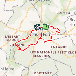
Randonnée Marche de 11,7 km à découvrir à Normandie, Eure, Lyons-la-Forêt. Cette randonnée est proposée par marcel.F.
Description
Fête de la Randonnée à Lyons la Forêt le 15 septembre 2019
départ parking de la poste
Localisation
Pays :
France
Région :
Normandie
Département/Province :
Eure
Commune :
Lyons-la-Forêt
Localité :
Unknown
Départ:(Dec)
Départ:(UTM)
389650 ; 5472957 (31U) N.
Commentaires
Randonnées à proximité
![Randonnée Marche Lyons-la-Forêt - Sentier de la Fontaineresse - Lyons la Forêt - Photo](https://media.geolcdn.com/t/375/260/ext.jpg?maxdim=2&url=https%3A%2F%2Fservices.sitytrail.com%2FGeolivesWS%2FDownloadMedia.ashx%3FTrailID%3D191376%26Media%3D14945_6.jpg)
![Marche Marche](https://static1.geolcdn.com/sitytour/trail-icons/101.png)
Sentier de la Fontaineresse - Lyons la Forêt
Marche
Facile
(1)
Lyons-la-Forêt,
Normandie,
Eure,
France
![](/images/other/stat-length.png)
6,3 km | 8,1 km-effort
2h 0min
![](https://static1.geolcdn.com/siteimages/upload/files/16400158638029165_repeat_loop_refresh_sync_direction_icon.png)
Oui
![Randonnée Marche nordique Beauficel-en-Lyons - Marche Nordique 85 - Carrefour d'Auteil - Forêt de Lyons - Photo](https://media.geolcdn.com/t/375/260/ext.jpg?maxdim=2&url=https%3A%2F%2Fstatic1.geolcdn.com%2Fsiteimages%2Fupload%2Ffiles%2F1545311037marcheuse_200dpi.jpg)
![Marche nordique Marche nordique](https://static1.geolcdn.com/sitytour/trail-icons/102.png)
Marche Nordique 85 - Carrefour d'Auteil - Forêt de Lyons
Marche nordique
Facile
(1)
Beauficel-en-Lyons,
Normandie,
Eure,
France
![](/images/other/stat-length.png)
9,5 km | 11,6 km-effort
1h 30min
![](https://static1.geolcdn.com/siteimages/upload/files/16400158638029165_repeat_loop_refresh_sync_direction_icon.png)
Oui
![Randonnée Marche Lyons-la-Forêt - Lyons la Forêt - Le Val Bagnard 12 - Photo](https://media.geolcdn.com/t/375/260/ext.jpg?maxdim=2&url=https%3A%2F%2Fstatic1.geolcdn.com%2Fsiteimages%2Fupload%2Ffiles%2F1553511878bg_sport_marche.png)
![Marche Marche](https://static1.geolcdn.com/sitytour/trail-icons/101.png)
Lyons la Forêt - Le Val Bagnard 12
Marche
Moyen
(1)
Lyons-la-Forêt,
Normandie,
Eure,
France
![](/images/other/stat-length.png)
12,2 km | 15,1 km-effort
2h 35min
![](https://static1.geolcdn.com/siteimages/upload/files/16400158638029165_repeat_loop_refresh_sync_direction_icon.png)
Oui
![Randonnée Marche nordique Lyons-la-Forêt - MN 66 L'Essart Mador - Photo](https://media.geolcdn.com/t/375/260/ext.jpg?maxdim=2&url=https%3A%2F%2Fstatic1.geolcdn.com%2Fsiteimages%2Fupload%2Ffiles%2F1545311037marcheuse_200dpi.jpg)
![Marche nordique Marche nordique](https://static1.geolcdn.com/sitytour/trail-icons/102.png)
MN 66 L'Essart Mador
Marche nordique
Facile
(2)
Lyons-la-Forêt,
Normandie,
Eure,
France
![](/images/other/stat-length.png)
8,9 km | 10,8 km-effort
1h 30min
![](https://static1.geolcdn.com/siteimages/upload/files/16400158638029165_repeat_loop_refresh_sync_direction_icon.png)
Oui
![Randonnée Marche nordique Lyons-la-Forêt - Marche Nordique 37 Lyons la Forêt - Photo](https://media.geolcdn.com/t/375/260/ext.jpg?maxdim=2&url=https%3A%2F%2Fstatic1.geolcdn.com%2Fsiteimages%2Fupload%2Ffiles%2F1545311037marcheuse_200dpi.jpg)
![Marche nordique Marche nordique](https://static1.geolcdn.com/sitytour/trail-icons/102.png)
Marche Nordique 37 Lyons la Forêt
Marche nordique
Facile
(2)
Lyons-la-Forêt,
Normandie,
Eure,
France
![](/images/other/stat-length.png)
7,8 km | 9,8 km-effort
1h 30min
![](https://static1.geolcdn.com/siteimages/upload/files/16400158638029165_repeat_loop_refresh_sync_direction_icon.png)
Oui
![Randonnée Marche nordique Lyons-la-Forêt - Marche Nordique 65 - Forêt de lyons - Photo](https://media.geolcdn.com/t/375/260/ext.jpg?maxdim=2&url=https%3A%2F%2Fstatic1.geolcdn.com%2Fsiteimages%2Fupload%2Ffiles%2F1545311037marcheuse_200dpi.jpg)
![Marche nordique Marche nordique](https://static1.geolcdn.com/sitytour/trail-icons/102.png)
Marche Nordique 65 - Forêt de lyons
Marche nordique
Facile
(1)
Lyons-la-Forêt,
Normandie,
Eure,
France
![](/images/other/stat-length.png)
8,6 km | 9,9 km-effort
Inconnu
![](https://static1.geolcdn.com/siteimages/upload/files/16400158638029165_repeat_loop_refresh_sync_direction_icon.png)
Oui
![Randonnée Marche nordique Rosay-sur-Lieure - Marche Nordique 59 Rosay sur Lieure - Photo](https://media.geolcdn.com/t/375/260/ext.jpg?maxdim=2&url=https%3A%2F%2Fstatic1.geolcdn.com%2Fsiteimages%2Fupload%2Ffiles%2F1545311037marcheuse_200dpi.jpg)
![Marche nordique Marche nordique](https://static1.geolcdn.com/sitytour/trail-icons/102.png)
Marche Nordique 59 Rosay sur Lieure
Marche nordique
Moyen
(1)
Rosay-sur-Lieure,
Normandie,
Eure,
France
![](/images/other/stat-length.png)
9,2 km | 10,9 km-effort
1h 30min
![](https://static1.geolcdn.com/siteimages/upload/files/16400158638029165_repeat_loop_refresh_sync_direction_icon.png)
Oui
![Randonnée Marche Rosay-sur-Lieure - Rando Douce 1 - Rosay sur Lieure - Photo](https://media.geolcdn.com/t/375/260/ext.jpg?maxdim=2&url=https%3A%2F%2Fstatic1.geolcdn.com%2Fsiteimages%2Fupload%2Ffiles%2F1553511878bg_sport_marche.png)
![Marche Marche](https://static1.geolcdn.com/sitytour/trail-icons/101.png)
Rando Douce 1 - Rosay sur Lieure
Marche
Moyen
(1)
Rosay-sur-Lieure,
Normandie,
Eure,
France
![](/images/other/stat-length.png)
6,2 km | 7,6 km-effort
2h 0min
![](https://static1.geolcdn.com/siteimages/upload/files/16400158638029165_repeat_loop_refresh_sync_direction_icon.png)
Oui
![Randonnée Marche Rosay-sur-Lieure - Rosay-sur-Lieure - vers Charleval - Photo](https://media.geolcdn.com/t/375/260/ext.jpg?maxdim=2&url=https%3A%2F%2Fstatic1.geolcdn.com%2Fsiteimages%2Fupload%2Ffiles%2F1553511878bg_sport_marche.png)
![Marche Marche](https://static1.geolcdn.com/sitytour/trail-icons/101.png)
Rosay-sur-Lieure - vers Charleval
Marche
Facile
(1)
Rosay-sur-Lieure,
Normandie,
Eure,
France
![](/images/other/stat-length.png)
9,4 km | 11,6 km-effort
3h 1min
![](https://static1.geolcdn.com/siteimages/upload/files/16400158638029165_repeat_loop_refresh_sync_direction_icon.png)
Oui