![](/images/other/stat-length.png)
![Randonnée Marche Carbis Bay - zennor - Photo](https://media.geolcdn.com/t/1900/400/ext.pjpeg?maxdim=2&url=https%3A%2F%2Fstatic1.geolcdn.com%2Fsiteimages%2Fupload%2Ffiles%2F1553511878bg_sport_marche.png)
zennor
cecile_ya
Utilisateur
![Longueur](/images/other/stat-length.png)
Longueur
11,7 km
![Altitude max](https://static1.geolcdn.com/siteimages/upload/files/1508320355ic_sort_altitude_max_24dp.png)
Altitude max
160 m
![Dénivelé positif](https://static1.geolcdn.com/siteimages/upload/files/1508320355ic_sort_den_pos_24dp.png)
Dénivelé positif
429 m
![Km-Effort](/images/other/stat-length.png)
Km-Effort
17 km
![Altitude min](https://static1.geolcdn.com/siteimages/upload/files/1508320355ic_sort_altitude_min_24dp.png)
Altitude min
8 m
![Dénivelé négatif](https://static1.geolcdn.com/siteimages/upload/files/1508320355ic_sort_den_neg_24dp.png)
Dénivelé négatif
296 m
![Boucle](https://static1.geolcdn.com/siteimages/upload/files/16400158638029165_repeat_loop_refresh_sync_direction_icon.png)
Boucle
Non
Date de création :
2019-06-23 09:16:54.466
Dernière modification :
2019-06-23 15:38:03.745
![Marche](https://static1.geolcdn.com/sitytour/trail-icons/101.png)
5h28
Difficulté : Difficile
![Scannez ce code QR pour ouvrir la randonnée dans l'application SityTrail](https://capi.geolives.com/qq0zvz2zws4bq2lad0pu/sitytour/trails/2122014/qr.png?size=200)
Application GPS de randonnée GRATUITE
À propos
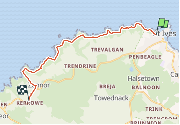
Randonnée Marche de 11,7 km à découvrir à Angleterre, Cornouailles. Cette randonnée est proposée par cecile_ya.
Description
splendide côte mais journée de pluie😣 la fin juin nous permet de voir les digitales et les bruyères, la mer est émeraude. le passage de rochers près de la plage avant Zennor point n'a de chemin que le nom.
Localisation
Pays :
Royaume-Uni
Région :
Angleterre
Département/Province :
Cornouailles
Commune :
Carbis Bay
Localité :
Unknown
Départ:(Dec)
Départ:(UTM)
322707 ; 5565413 (30U) N.
Commentaires
Randonnées à proximité
![Randonnée Marche - pendeen-drnnen cove + ale au old success Inn (stopwatch+30 Mon) - Photo](https://media.geolcdn.com/t/375/260/ext.jpg?maxdim=2&url=https%3A%2F%2Fstatic1.geolcdn.com%2Fsiteimages%2Fupload%2Ffiles%2F1553511878bg_sport_marche.png)
![Marche Marche](https://static1.geolcdn.com/sitytour/trail-icons/101.png)
pendeen-drnnen cove + ale au old success Inn (stopwatch+30 Mon)
Marche
Moyen
,
Angleterre,
Cornouailles,
Royaume-Uni
![](/images/other/stat-length.png)
17,2 km | 23 km-effort
7h 2min
![](https://static1.geolcdn.com/siteimages/upload/files/16400158638029165_repeat_loop_refresh_sync_direction_icon.png)
Non
![Randonnée Marche - penzance à St Michaël mounts et retour - Photo](https://media.geolcdn.com/t/375/260/ext.jpg?maxdim=2&url=https%3A%2F%2Fstatic1.geolcdn.com%2Fsiteimages%2Fupload%2Ffiles%2F1553511878bg_sport_marche.png)
![Marche Marche](https://static1.geolcdn.com/sitytour/trail-icons/101.png)
penzance à St Michaël mounts et retour
Marche
Très facile
,
Angleterre,
Cornouailles,
Royaume-Uni
![](/images/other/stat-length.png)
13,9 km | 15 km-effort
3h 41min
![](https://static1.geolcdn.com/siteimages/upload/files/16400158638029165_repeat_loop_refresh_sync_direction_icon.png)
Oui
![Randonnée Marche - Cornouaille Ouest - Photo](https://media.geolcdn.com/t/375/260/ext.jpg?maxdim=2&url=https%3A%2F%2Fstatic1.geolcdn.com%2Fsiteimages%2Fupload%2Ffiles%2F1553511878bg_sport_marche.png)
![Marche Marche](https://static1.geolcdn.com/sitytour/trail-icons/101.png)
Cornouaille Ouest
Marche
Facile
,
Angleterre,
Cornouailles,
Royaume-Uni
![](/images/other/stat-length.png)
14,8 km | 18,8 km-effort
4h 15min
![](https://static1.geolcdn.com/siteimages/upload/files/16400158638029165_repeat_loop_refresh_sync_direction_icon.png)
Oui
![Randonnée Marche - sortie du 13septembre - Photo](https://media.geolcdn.com/t/375/260/ext.jpg?maxdim=2&url=https%3A%2F%2Fstatic1.geolcdn.com%2Fsiteimages%2Fupload%2Ffiles%2F1553511878bg_sport_marche.png)
![Marche Marche](https://static1.geolcdn.com/sitytour/trail-icons/101.png)
sortie du 13septembre
Marche
Très facile
,
Angleterre,
Cornouailles,
Royaume-Uni
![](/images/other/stat-length.png)
7,2 km | 10,1 km-effort
4h 59min
![](https://static1.geolcdn.com/siteimages/upload/files/16400158638029165_repeat_loop_refresh_sync_direction_icon.png)
Oui
![Randonnée Marche - sortie du 10 septembre - Photo](https://media.geolcdn.com/t/375/260/ext.jpg?maxdim=2&url=https%3A%2F%2Fstatic1.geolcdn.com%2Fsiteimages%2Fupload%2Ffiles%2F1553511878bg_sport_marche.png)
![Marche Marche](https://static1.geolcdn.com/sitytour/trail-icons/101.png)
sortie du 10 septembre
Marche
Très facile
,
Angleterre,
Cornouailles,
Royaume-Uni
![](/images/other/stat-length.png)
7,9 km | 10,5 km-effort
5h 14min
![](https://static1.geolcdn.com/siteimages/upload/files/16400158638029165_repeat_loop_refresh_sync_direction_icon.png)
Oui
![Randonnée Marche - marche du 08 septembre 20a9 - Photo](https://media.geolcdn.com/t/375/260/ext.jpg?maxdim=2&url=https%3A%2F%2Fstatic1.geolcdn.com%2Fsiteimages%2Fupload%2Ffiles%2F1553511878bg_sport_marche.png)
![Marche Marche](https://static1.geolcdn.com/sitytour/trail-icons/101.png)
marche du 08 septembre 20a9
Marche
Très facile
,
Angleterre,
Cornouailles,
Royaume-Uni
![](/images/other/stat-length.png)
7,7 km | 10,1 km-effort
4h 30min
![](https://static1.geolcdn.com/siteimages/upload/files/16400158638029165_repeat_loop_refresh_sync_direction_icon.png)
Oui
![Randonnée Marche - St-Just - Cape Cornwall - Photo](https://media.geolcdn.com/t/375/260/ext.jpg?maxdim=2&url=https%3A%2F%2Fstatic1.geolcdn.com%2Fsiteimages%2Fupload%2Ffiles%2F1553511878bg_sport_marche.png)
![Marche Marche](https://static1.geolcdn.com/sitytour/trail-icons/101.png)
St-Just - Cape Cornwall
Marche
Moyen
,
Angleterre,
Cornouailles,
Royaume-Uni
![](/images/other/stat-length.png)
8,1 km | 10,8 km-effort
2h 17min
![](https://static1.geolcdn.com/siteimages/upload/files/16400158638029165_repeat_loop_refresh_sync_direction_icon.png)
Oui