![](/images/other/stat-length.png)
![Randonnée Marche Vescles - Le Pic d'Oliferne - Photo](https://media.geolcdn.com/t/1900/400/ext.pjpeg?maxdim=2&url=https%3A%2F%2Fservices.sitytrail.com%2FGeolivesWS%2FDownloadMedia.ashx%3FTrailID%3D212032%26Media%3Dfix__20130811155648.jpg)
Le Pic d'Oliferne
albert39
Utilisateur
![Longueur](/images/other/stat-length.png)
Longueur
12,5 km
![Altitude max](https://static1.geolcdn.com/siteimages/upload/files/1508320355ic_sort_altitude_max_24dp.png)
Altitude max
787 m
![Dénivelé positif](https://static1.geolcdn.com/siteimages/upload/files/1508320355ic_sort_den_pos_24dp.png)
Dénivelé positif
383 m
![Km-Effort](/images/other/stat-length.png)
Km-Effort
17,6 km
![Altitude min](https://static1.geolcdn.com/siteimages/upload/files/1508320355ic_sort_altitude_min_24dp.png)
Altitude min
517 m
![Dénivelé négatif](https://static1.geolcdn.com/siteimages/upload/files/1508320355ic_sort_den_neg_24dp.png)
Dénivelé négatif
381 m
![Boucle](https://static1.geolcdn.com/siteimages/upload/files/16400158638029165_repeat_loop_refresh_sync_direction_icon.png)
Boucle
Oui
Date de création :
2014-12-10 00:00:00.0
Dernière modification :
2014-12-10 00:00:00.0
![Marche](https://static1.geolcdn.com/sitytour/trail-icons/101.png)
3h46
Difficulté : Difficile
![Scannez ce code QR pour ouvrir la randonnée dans l'application SityTrail](https://capi.geolives.com/qq0zvz2zws4bq2lad0pu/sitytour/trails/212032/qr.png?size=200)
Application GPS de randonnée GRATUITE
À propos
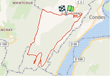
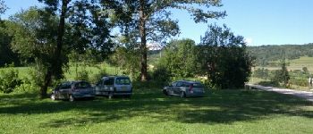
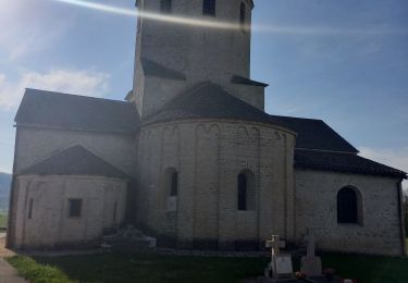
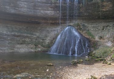
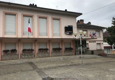
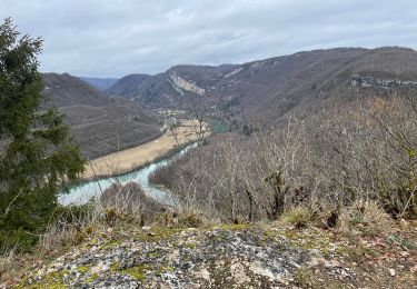
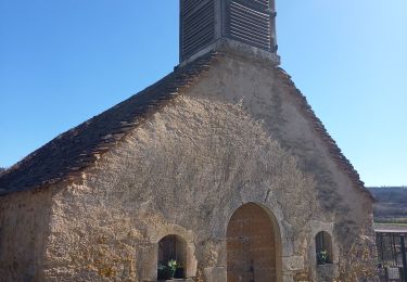
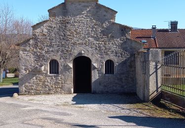
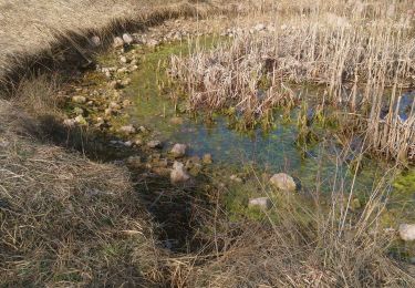
Randonnée Marche de 12,5 km à découvrir à Bourgogne-Franche-Comté, Jura, Vescles. Cette randonnée est proposée par albert39.
Description
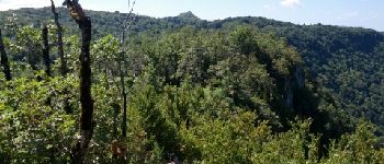
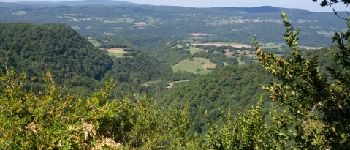
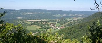
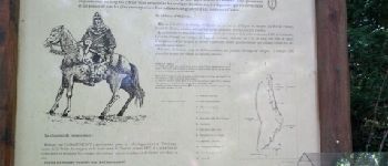
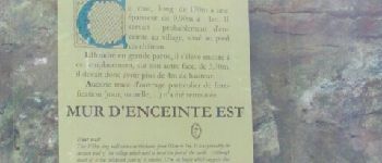
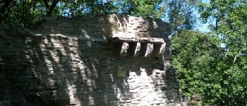
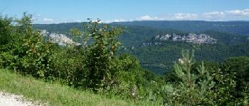
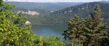
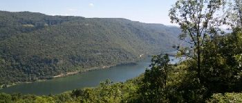
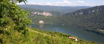
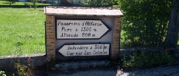
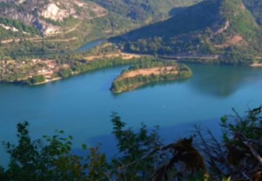
Superbe belvédère au-dessus des vallées de l'Ain et de la Valouse, la pic d'Oliferne est aussi un lieu chargé d’histoire et de légendes fantastiques.
Points d'intérêt
Localisation
Pays :
France
Région :
Bourgogne-Franche-Comté
Département/Province :
Jura
Commune :
Vescles
Localité :
Unknown
Départ:(Dec)
Départ:(UTM)
700612 ; 5134895 (31T) N.
Commentaires
Randonnées à proximité
![Randonnée Marche Dortan - dortan - Photo](https://media.geolcdn.com/t/375/260/92b3033b-7712-4a3b-9007-597555739d0c.jpg&format=jpg&maxdim=2)
![Marche Marche](https://static1.geolcdn.com/sitytour/trail-icons/101.png)
![Randonnée Marche Dortan - col de la Tendue pierre qui vire - Photo](https://media.geolcdn.com/t/375/260/58a49901-ab7e-49f1-b0d0-8b7cb0f7204a.jpg&format=jpg&maxdim=2)
![Marche Marche](https://static1.geolcdn.com/sitytour/trail-icons/101.png)
col de la Tendue pierre qui vire
Marche
Difficile
Dortan,
Auvergne-Rhône-Alpes,
Ain,
France
![](/images/other/stat-length.png)
9,2 km | 15,5 km-effort
2h 51min
![](https://static1.geolcdn.com/siteimages/upload/files/16400158638029165_repeat_loop_refresh_sync_direction_icon.png)
Oui
![Randonnée Marche Saint-Hymetière-sur-Valouse - st hymetiere jura - Photo](https://media.geolcdn.com/t/375/260/2a4708b4-800e-4d01-971c-ff06ae1eada6.jpg&format=jpg&maxdim=2)
![Marche Marche](https://static1.geolcdn.com/sitytour/trail-icons/101.png)
st hymetiere jura
Marche
Difficile
Saint-Hymetière-sur-Valouse,
Bourgogne-Franche-Comté,
Jura,
France
![](/images/other/stat-length.png)
11,9 km | 15,2 km-effort
21h 27min
![](https://static1.geolcdn.com/siteimages/upload/files/16400158638029165_repeat_loop_refresh_sync_direction_icon.png)
Oui
![Randonnée Marche Dortan - vouais. la pierre qui vire.la cascade de la combe. - Photo](https://media.geolcdn.com/t/375/260/5f8b3633-bbf6-4a49-948c-9315092f03da.jpg&format=jpg&maxdim=2)
![Marche Marche](https://static1.geolcdn.com/sitytour/trail-icons/101.png)
vouais. la pierre qui vire.la cascade de la combe.
Marche
Facile
Dortan,
Auvergne-Rhône-Alpes,
Ain,
France
![](/images/other/stat-length.png)
10 km | 14,7 km-effort
2h 51min
![](https://static1.geolcdn.com/siteimages/upload/files/16400158638029165_repeat_loop_refresh_sync_direction_icon.png)
Oui
![Randonnée A pied Dortan - La Pierre qui vire - Photo](https://media.geolcdn.com/t/375/260/3e210a43-ea7d-498b-a5d8-2880f86b08ad.jpeg&format=jpg&maxdim=2)
![A pied A pied](https://static1.geolcdn.com/sitytour/trail-icons/100.png)
La Pierre qui vire
A pied
Facile
Dortan,
Auvergne-Rhône-Alpes,
Ain,
France
![](/images/other/stat-length.png)
3,1 km | 6,1 km-effort
1h 23min
![](https://static1.geolcdn.com/siteimages/upload/files/16400158638029165_repeat_loop_refresh_sync_direction_icon.png)
Non
![Randonnée Marche Dortan - Boucle sur les hauteurs de Dortan - Photo](https://media.geolcdn.com/t/375/260/ee5d509c-2a81-4e42-9bbc-67adf4dcc2b1.jpg&format=jpg&maxdim=2)
![Marche Marche](https://static1.geolcdn.com/sitytour/trail-icons/101.png)
Boucle sur les hauteurs de Dortan
Marche
Moyen
Dortan,
Auvergne-Rhône-Alpes,
Ain,
France
![](/images/other/stat-length.png)
18,1 km | 28 km-effort
4h 35min
![](https://static1.geolcdn.com/siteimages/upload/files/16400158638029165_repeat_loop_refresh_sync_direction_icon.png)
Oui
![Randonnée Marche Dortan - vouais - Photo](https://media.geolcdn.com/t/375/260/8c0e39ff-f905-4874-b772-0eca47f74074.jpg&format=jpg&maxdim=2)
![Marche Marche](https://static1.geolcdn.com/sitytour/trail-icons/101.png)
vouais
Marche
Difficile
Dortan,
Auvergne-Rhône-Alpes,
Ain,
France
![](/images/other/stat-length.png)
14,3 km | 22 km-effort
7h 11min
![](https://static1.geolcdn.com/siteimages/upload/files/16400158638029165_repeat_loop_refresh_sync_direction_icon.png)
Oui
![Randonnée Marche Dortan - dortan .la pierre qui vire .les 3 dammetes et retour dortant retour - Photo](https://media.geolcdn.com/t/375/260/02535d49-f093-484f-bd82-a87ac69d8bc7.jpg&format=jpg&maxdim=2)
![Marche Marche](https://static1.geolcdn.com/sitytour/trail-icons/101.png)
dortan .la pierre qui vire .les 3 dammetes et retour dortant retour
Marche
Moyen
Dortan,
Auvergne-Rhône-Alpes,
Ain,
France
![](/images/other/stat-length.png)
13,7 km | 20 km-effort
4h 32min
![](https://static1.geolcdn.com/siteimages/upload/files/16400158638029165_repeat_loop_refresh_sync_direction_icon.png)
Oui
![Randonnée Marche Vescles - Vescles Sous le pic d'oliferne - Photo](https://media.geolcdn.com/t/375/260/a527fee7-72a4-441d-9a76-f762b4095043.jpg&format=jpg&maxdim=2)
![Marche Marche](https://static1.geolcdn.com/sitytour/trail-icons/101.png)
Vescles Sous le pic d'oliferne
Marche
Moyen
Vescles,
Bourgogne-Franche-Comté,
Jura,
France
![](/images/other/stat-length.png)
13,3 km | 18 km-effort
3h 5min
![](https://static1.geolcdn.com/siteimages/upload/files/16400158638029165_repeat_loop_refresh_sync_direction_icon.png)
Oui