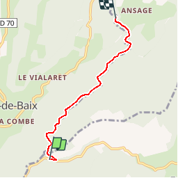
![](/images/other/stat-length.png)
![Randonnée Marche Eygluy-Escoulin - Balade au long de la Gervanne - Description et photos - Photo](https://media.geolcdn.com/t/1900/400/ext.pjpeg?maxdim=2&url=https%3A%2F%2Fservices.sitytrail.com%2FGeolivesWS%2FDownloadMedia.ashx%3FTrailID%3D211816%26Media%3D7a78f742-30fa-480b-a10b-77b5ec10adf1.jpg)
Balade au long de la Gervanne - Description et photos
bob2023
Utilisateur
![Longueur](/images/other/stat-length.png)
![Altitude max](https://static1.geolcdn.com/siteimages/upload/files/1508320355ic_sort_altitude_max_24dp.png)
![Dénivelé positif](https://static1.geolcdn.com/siteimages/upload/files/1508320355ic_sort_den_pos_24dp.png)
![Km-Effort](/images/other/stat-length.png)
![Altitude min](https://static1.geolcdn.com/siteimages/upload/files/1508320355ic_sort_altitude_min_24dp.png)
![Dénivelé négatif](https://static1.geolcdn.com/siteimages/upload/files/1508320355ic_sort_den_neg_24dp.png)
![Boucle](https://static1.geolcdn.com/siteimages/upload/files/16400158638029165_repeat_loop_refresh_sync_direction_icon.png)
![Marche](https://static1.geolcdn.com/sitytour/trail-icons/101.png)
1h33
Difficulté : Facile
![Scannez ce code QR pour ouvrir la randonnée dans l'application SityTrail](https://capi.geolives.com/qq0zvz2zws4bq2lad0pu/sitytour/trails/211816/qr.png?size=200)
Application GPS de randonnée GRATUITE
À propos
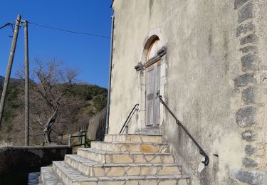
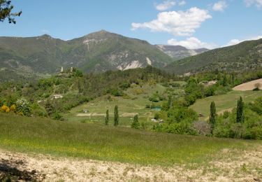
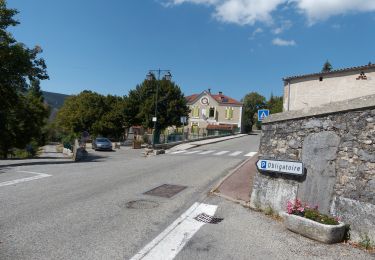
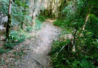
Randonnée Marche de 4,3 km à découvrir à Auvergne-Rhône-Alpes, Drôme, Eygluy-Escoulin. Cette randonnée est proposée par bob2023.
Description
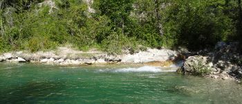
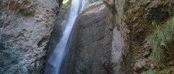
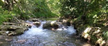
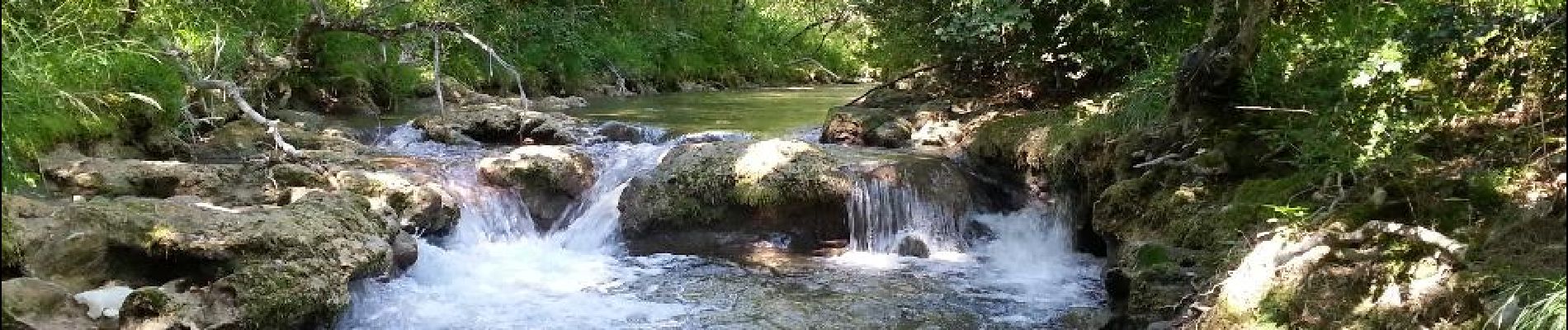
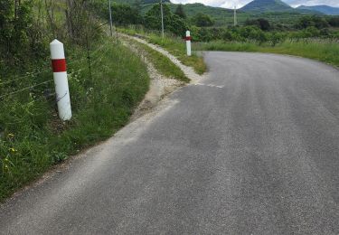
Se garer en bordure de route. Très belle rando. à faire par temps chaud. Nombreux passages dans l'eau (prévoir chaussures adéquates). Plutôt que de suivre le sentier il est possible et très agréable de remonter la Gervanne les pieds dans l'eau, vous arriverez au pied de la chute de la Druise. Les bâtons seront très utiles pour marcher dans le lit de la rivière. Pour le retour, même chemin, total environ 9 km. Note 9/10.
Localisation
Commentaires
Randonnées à proximité
![Randonnée Marche Eygluy-Escoulin - 26 bec pointu zel 10.11.22 - Photo](https://media.geolcdn.com/t/375/260/ext.jpg?maxdim=2&url=https%3A%2F%2Fstatic1.geolcdn.com%2Fsiteimages%2Fupload%2Ffiles%2F1553511878bg_sport_marche.png)
![Marche Marche](https://static1.geolcdn.com/sitytour/trail-icons/101.png)
Marche
![](/images/other/stat-length.png)
![](https://static1.geolcdn.com/siteimages/upload/files/16400158638029165_repeat_loop_refresh_sync_direction_icon.png)
![Randonnée Marche Beaufort-sur-Gervanne - 26 gervanne druise plan de baix - Photo](https://media.geolcdn.com/t/375/260/cef04867-033e-4aa7-8c70-c5079a2317fe.jpg&format=jpg&maxdim=2)
![Marche Marche](https://static1.geolcdn.com/sitytour/trail-icons/101.png)
Marche
![](/images/other/stat-length.png)
![](https://static1.geolcdn.com/siteimages/upload/files/16400158638029165_repeat_loop_refresh_sync_direction_icon.png)
![Randonnée Marche Beaufort-sur-Gervanne - Beaufort St Pancrace 15km - Photo](https://media.geolcdn.com/t/375/260/ext.jpg?maxdim=2&url=https%3A%2F%2Fstatic1.geolcdn.com%2Fsiteimages%2Fupload%2Ffiles%2F1553511878bg_sport_marche.png)
![Marche Marche](https://static1.geolcdn.com/sitytour/trail-icons/101.png)
Marche
![](/images/other/stat-length.png)
![](https://static1.geolcdn.com/siteimages/upload/files/16400158638029165_repeat_loop_refresh_sync_direction_icon.png)
![Randonnée Marche Eygluy-Escoulin - 26 escoulin berches ayes - Photo](https://media.geolcdn.com/t/375/260/5381e54b-64ec-4f45-8508-60345424d51d.jpg&format=jpg&maxdim=2)
![Marche Marche](https://static1.geolcdn.com/sitytour/trail-icons/101.png)
Marche
![](/images/other/stat-length.png)
![](https://static1.geolcdn.com/siteimages/upload/files/16400158638029165_repeat_loop_refresh_sync_direction_icon.png)
![Randonnée Marche Beaufort-sur-Gervanne - Beaufort - Gigors - Lozeron - Photo](https://media.geolcdn.com/t/375/260/8cacbdb2-dbdb-432d-83ba-9c60bb3f8279.jpg&format=jpg&maxdim=2)
![Marche Marche](https://static1.geolcdn.com/sitytour/trail-icons/101.png)
Marche
![](/images/other/stat-length.png)
![](https://static1.geolcdn.com/siteimages/upload/files/16400158638029165_repeat_loop_refresh_sync_direction_icon.png)
![Randonnée Marche Beaufort-sur-Gervanne - BEAUFORT ET GERVANNE - Photo](https://media.geolcdn.com/t/375/260/9acf945f-4780-431b-bb4b-3d77cb822b0f.jpg&format=jpg&maxdim=2)
![Marche Marche](https://static1.geolcdn.com/sitytour/trail-icons/101.png)
Marche
![](/images/other/stat-length.png)
![](https://static1.geolcdn.com/siteimages/upload/files/16400158638029165_repeat_loop_refresh_sync_direction_icon.png)
![Randonnée Marche Eygluy-Escoulin - Le Taillefer - Escoulin - Photo](https://media.geolcdn.com/t/375/260/a320a5a5-0487-4886-a0f3-90a4c7c70715.jpg&format=jpg&maxdim=2)
![Marche Marche](https://static1.geolcdn.com/sitytour/trail-icons/101.png)
Marche
![](/images/other/stat-length.png)
![](https://static1.geolcdn.com/siteimages/upload/files/16400158638029165_repeat_loop_refresh_sync_direction_icon.png)
![Randonnée Marche Plan-de-Baix - Canyon des Gueulards - Plateau du Vellan - Photo](https://media.geolcdn.com/t/375/260/df942d02-3843-4e15-b86a-2050f17fdf62.jpg&format=jpg&maxdim=2)
![Marche Marche](https://static1.geolcdn.com/sitytour/trail-icons/101.png)
Marche
![](/images/other/stat-length.png)
![](https://static1.geolcdn.com/siteimages/upload/files/16400158638029165_repeat_loop_refresh_sync_direction_icon.png)
![Randonnée Marche Plan-de-Baix - Le Canyon des Gueulards - Photo](https://media.geolcdn.com/t/375/260/138e2d3e-d109-4451-9e9f-dc740c8ceb56.jpg&format=jpg&maxdim=2)
![Marche Marche](https://static1.geolcdn.com/sitytour/trail-icons/101.png)
Marche
![](/images/other/stat-length.png)
![](https://static1.geolcdn.com/siteimages/upload/files/16400158638029165_repeat_loop_refresh_sync_direction_icon.png)